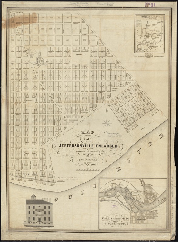
Map of Jeffersonville enlarged
Item Information
- Title:
- Map of Jeffersonville enlarged
- Creator:
- Barnum, H. L.
- Name on Item:
-
surveyed and delineated by H.L. Barnum civil engineer ; engraved by Doolittle & Munson Cincinnati.
- Date:
-
1837
- Format:
-
Maps/Atlases
- Location:
-
Boston Public Library
Norman B. Leventhal Map & Education Center - Collection (local):
-
Norman B. Leventhal Map & Education Center Collection
- Subjects:
-
Real property--Indiana--Jeffersonville--Maps
Roads--Indiana--Maps
Railroads--Indiana--Maps
Canals--Indiana--Maps
Rapids--Ohio River--Maps
Jeffersonville (Ind.)--Maps
Falls of the Ohio (Ky. and Ind.)--Maps
- Places:
-
IndianaClark (county)Jeffersonville
Falls of the Ohio
- Extent:
- 1 map ; 70 x 51 cm.
- Terms of Use:
-
No known copyright restrictions.
No known restrictions on use.
- Publisher:
-
Cincinnati, Ohio :
[H.L. Barnum]
- Scale:
-
Scale [ca. 1:3,360]
- Language:
-
English
- Notes:
-
Insets: Outline map of Indiana shewing the location of the chartered and state canals, rail & McAdamized roads, etc. -- Falls of the Ohio and vicinity.
Includes ill. of Jeffersonville House, South Front.
Cadastral map.
- Identifier:
-
06_01_011465
- Call #:
-
G4094.J4G46 1837 .B3
- Barcode:
-
39999065685453