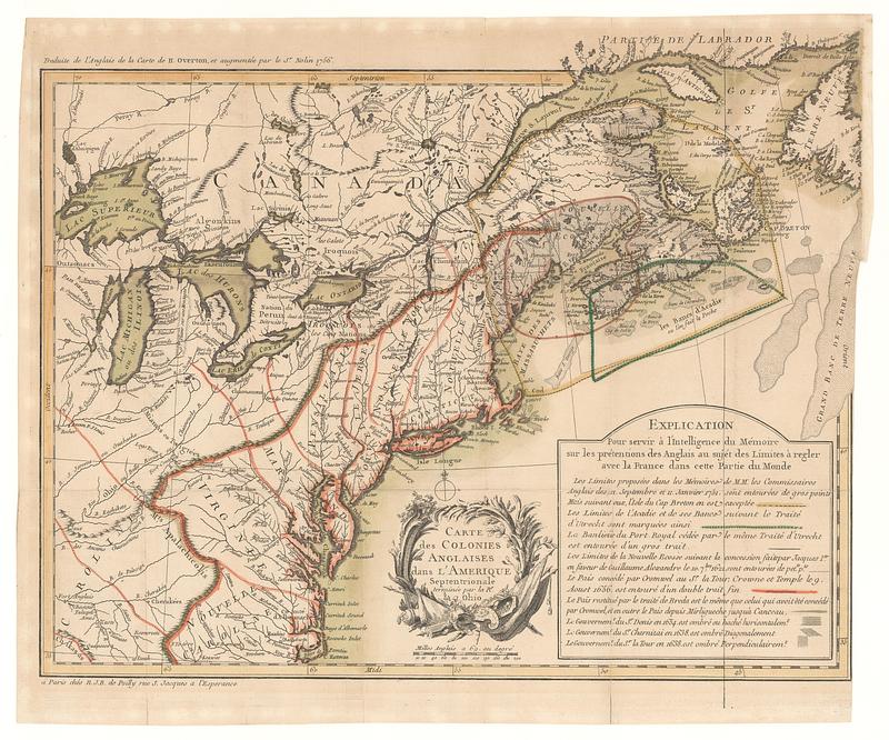
Carte des colonies anglaises dans l'Amerique Septentrionale terminée par le r.e Ohio
This map is also available in American Revolutionary Geographies Online (ARGO), a collections portal especially built for material relating to the American Revolutionary War Era. Visit ARGO to learn more about this item and explore the historical geography of North America in the late eighteenth century.
Item Information
- Title:
- Carte des colonies anglaises dans l'Amerique Septentrionale terminée par le r.e Ohio
- Publisher:
- Poilly, Nicolas-Jean-Baptiste de, 1707-1780
- Contributor:
- Nolin, Jean Baptiste, 1686-1762
- Date:
-
1756
- Format:
-
Maps/Atlases
- Location:
- MacLean Collection Map Library
- Collection (local):
-
MacLean Collection Map Library
- Subjects:
-
North America--Maps
- Places:
-
North America (area)
- Extent:
- 1 map ; 350 x 465 mm
- Terms of Use:
-
Public Domain/No known restrictions on use. Contact host institution to download image.
Contact host institution for more information.
- Publisher:
-
Paris :
Chés R.J.B. de Poilly rue S. Jacques a l’Esperance
- Language:
-
French
- Notes:
-
"Traduite de l'anglais de la carte de H. Overton, et augmentée par le S.r Nolin 1756."
- Identifier:
-
MC_821
- Call #:
-
821