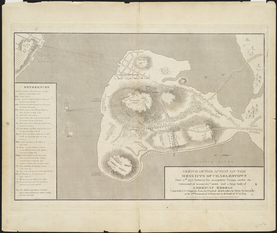
Sketch of the action on the heights of Charlestown, June 17th, 1775, between His Majesty's troops, under the command, of Major Genl. Howe, and a large body of American rebels
This map is also available in American Revolutionary Geographies Online (ARGO), a collections portal especially built for material relating to the American Revolutionary War Era. Visit ARGO to learn more about this item and explore the historical geography of North America in the late eighteenth century.
Item Information
- Title:
- Sketch of the action on the heights of Charlestown, June 17th, 1775, between His Majesty's troops, under the command, of Major Genl. Howe, and a large body of American rebels
- Title (uniform):
-
Analectic magazine
- Creator:
- Chapman, Isaac A.
- Cartographer:
- Chapman, Isaac A.
- Contributor:
- De Berniere, Henry
- Contributor:
- Cist, Jacob, 1782-1825
- Publisher:
- Thomas, Moses, 1787-1865
- Engraver:
- Kneass, Young & Co
- Name on Item:
-
copied by I.A. Chapman, from an original sketch, taken by Henry De Berniere, of the 14th Regiment, of Infantry, now in the hands of J. Cist, Esq. ; engraved by Kneass, Young & Co. for the Analectic magazine
- Date:
-
[1818]
- Format:
-
Maps/Atlases
- Location:
- Private Collection
- Collection (local):
-
Mapping Boston Collection
- Subjects:
-
Bunker Hill, Battle of, Boston, Mass., 1775--Maps
Charlestown (Boston, Mass.)--Maps
- Places:
-
MassachusettsSuffolk (county)BostonCharlestown
- Extent:
- 1 map ; 36 x 51 cm
- Terms of Use:
-
No known copyright restrictions.
This work is licensed for use under a Creative Commons Attribution Non-Commercial Share Alike License (CC BY-NC-SA).

- Publisher:
-
Philada. :
M. Thomas
- Scale:
-
Scale approximately 1:5,400
- Language:
-
English
- Notes:
-
Relief shown by hachures.
Oriented with north to the lower right.
A redrawing of a manuscript map presumed to have been made in 1775.
Includes "References" to points of military interest.
- Notes (date):
-
This date is inferred.
- Identifier:
-
06_01_001136
- Barcode:
-
39999065708024


