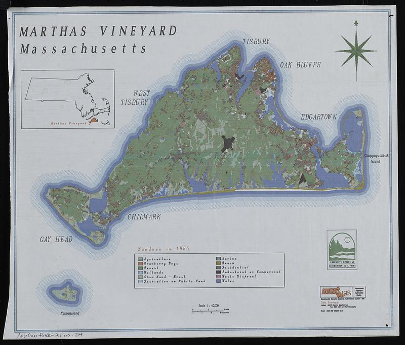
Marthas Vineyard, Massachusetts : landuse in 1985
Item Information
- Title:
- Marthas Vineyard, Massachusetts : landuse in 1985
- Title (alt.):
-
Marthas Vineyard, Massachusetts : land use in 1985
- Cartographer:
- MassGIS (Office : Mass.)
- Contributor:
- Massachusetts. Executive Office of Environmental Affairs
- Name on Item:
-
Executive Office of Environmental Affairs ; MassGIS
- Date:
-
1989
- Format:
-
Maps/Atlases
- Location:
-
Boston Public Library
Norman B. Leventhal Map & Education Center - Collection (local):
-
Applied Geographics, Inc. Records
- Subjects:
-
Martha's Vineyard (Mass.)--Maps
Land use--Massachusetts--Martha's Vineyard--Maps
- Places:
-
MassachusettsDukes (county)Martha's Vineyard (island)
- Extent:
- 1 map : color ; 81 x 96 cm
- Terms of Use:
-
No known copyright restrictions.
No known restrictions on use.
- Scale:
-
Scale 1:40,000
- Language:
-
English
- Notes:
-
Inset: Location map.
- Identifier:
-
06_01_019084
06_01_019085
- Call #:
-
AppGeo Folder 31 no. 24-25
- Barcode:
-
30000008064316


