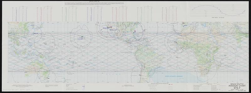
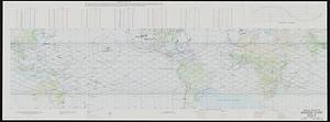
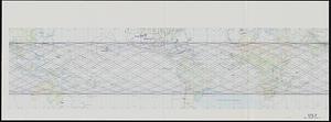
Space shuttle mission chart STS-7
Item Information
- Title:
- Space shuttle mission chart STS-7
- Cartographer:
- Aerospace Center (U.S.)
- Contributor:
- United States. National Aeronautics and Space Administration
- Name on Item:
-
prepared and published by the Defense Mapping Agency, Aerospace Center
- Date:
-
1982
- Format:
-
Maps/Atlases
- Location:
-
Boston Public Library
Norman B. Leventhal Map & Education Center - Collection (local):
-
Norman B. Leventhal Map & Education Center Collection
- Subjects:
-
Space vehicles--Tracking--Maps
Space shuttles--Maps
- Places:
-
World
- Extent:
- 2 maps : both sides, color ; 36 x 102 cm, on sheet 39 x 104 cm
- Terms of Use:
-
No known copyright restrictions.
No known restrictions on use.
- Publisher:
-
St. Louis AFS, Missouri :
Aerospace Center
- Edition:
- Edition-1
- Scale:
-
Scale 1:40,000,000 at the equator
- Language:
-
English
- Table of Contents:
-
Front - orbits 1 to 48
Back - orbits 49 to 112
- Notes:
-
Shows groundtrack data and spaceflight tracking and data network.
Relief shown by shading.
Includes table of "Ground elapsed time" and graph of "Orbit period-90 minutes."
"Lithographed by DMAAC 4-83."
- Notes (exhibitions):
-
Exhibited: "Processing place: how computers and cartographers redrew our world," organized by Norman B. Leventhal Map & Education Center at the Boston Public Library, 2024-2025
- Identifier:
-
06_01_019413
- Call #:
-
G3201.P75 1983
- Barcode:
-
39999085971511


