Atlas of the city of Boston, Boston proper and Back Bay : plate 22
Item Information
- Title:
- Atlas of the city of Boston, Boston proper and Back Bay : plate 22
- Description:
-
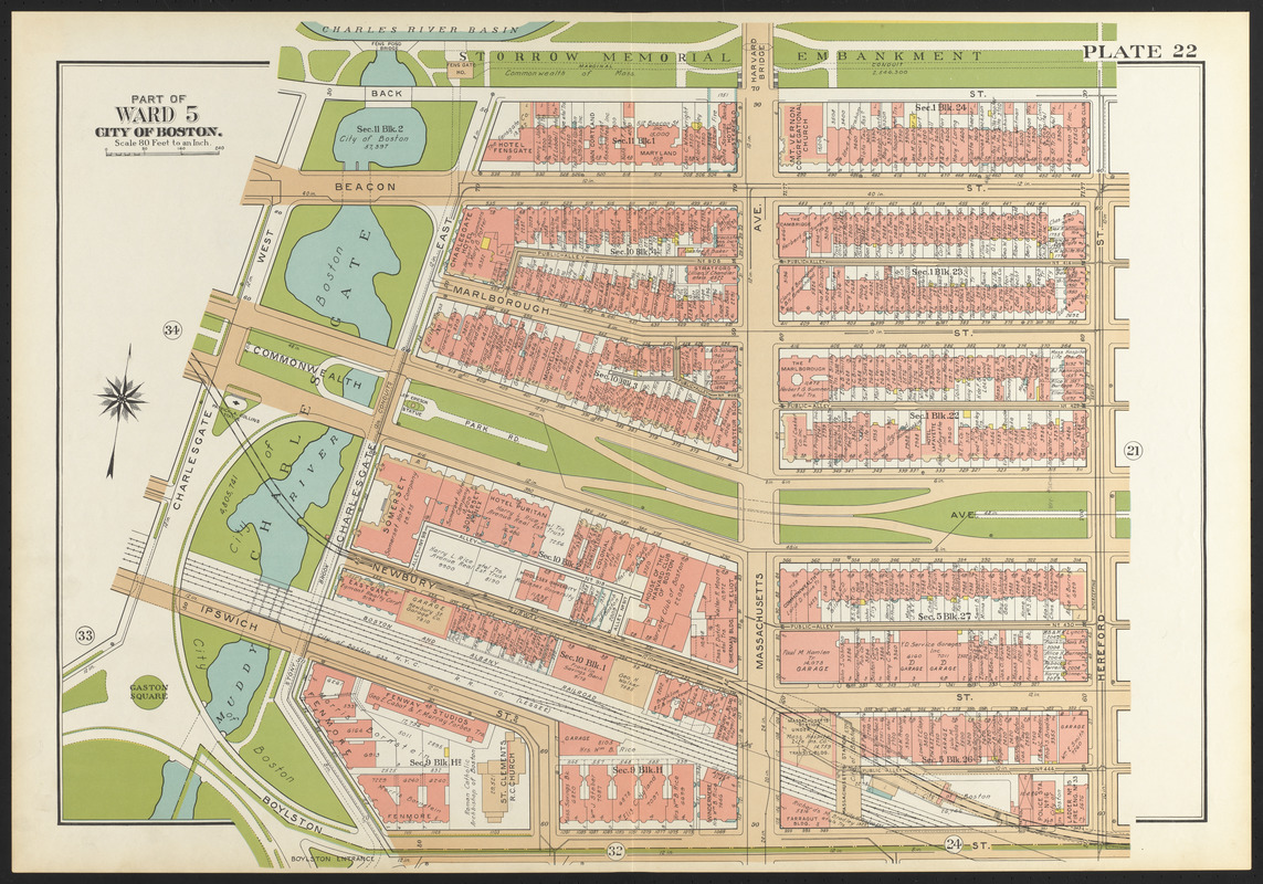
Landscape architect Frederick Law Olmsted began his first Boston project in 1878, when the Boston Park Commissioners hired him to design the Back Bay Park (now the Fens), both as a sanitary improvement to the polluted and flood-prone Stony Brook and Muddy River, and as a public recreation ground. Charlesgate, as it appears here, was intended as the meeting place of the Fens and the Charles River, although the mid-20th century construction of Storrow Drive and the Bowker Overpass divided them for over 60 years. Today, the Department of Conservation and Recreation and the Department of Transportation are working on a Charlesgate Greenway, which will reconnect the Fens and the Charles River Basin.
- Creator:
- G.W. Bromley & Co.
- Date:
-
1938
- Format:
-
Maps/Atlases
- Location:
-
Boston Public Library
Norman B. Leventhal Map & Education Center - Collection (local):
-
Norman B. Leventhal Map & Education Center Collection
- Subjects:
-
Boston (Mass.)--Maps
Real property--Massachusetts--Boston--Maps
Landowners--Massachusetts--Boston--Maps
Back Bay (Boston, Mass.)--Maps
- Places:
-
MassachusettsSuffolk (county)BostonBack Bay
- Extent:
- 1 map : color ; 51 x 77 cm
- Terms of Use:
-
No known copyright restrictions.
No known restrictions on use.
- Publisher:
-
Philadelphia :
G.W. Bromley & Co.
- Scale:
-
Scale 1:960
- Language:
-
English
- Notes (exhibitions):
-
Exhibited: "Breathing Room: Mapping Boston's Green Spaces" organized by the Norman B. Leventhal Map Center at the Boston Public Library, 2018.
- Identifier:
-
06_01_014593
- Call #:
-
G1234.B6 B7 1938
- Barcode:
-
39999059011690
![[Plan of boundary lines in Roxbury and the City of Boston]](https://bpldcassets.blob.core.windows.net/derivatives/images/commonwealth:1257bb127/image_thumbnail_300.jpg)

![Plan of lands on the Back Bay belonging to the Boston Water Power Co., the Commonwealth and other parthies [i.e. parties], showing the system of streets, grades and sewers as laid out and recommended by the Back Bay Commissioners](https://bpldcassets.blob.core.windows.net/derivatives/images/commonwealth:1257bb305/image_thumbnail_300.jpg)

