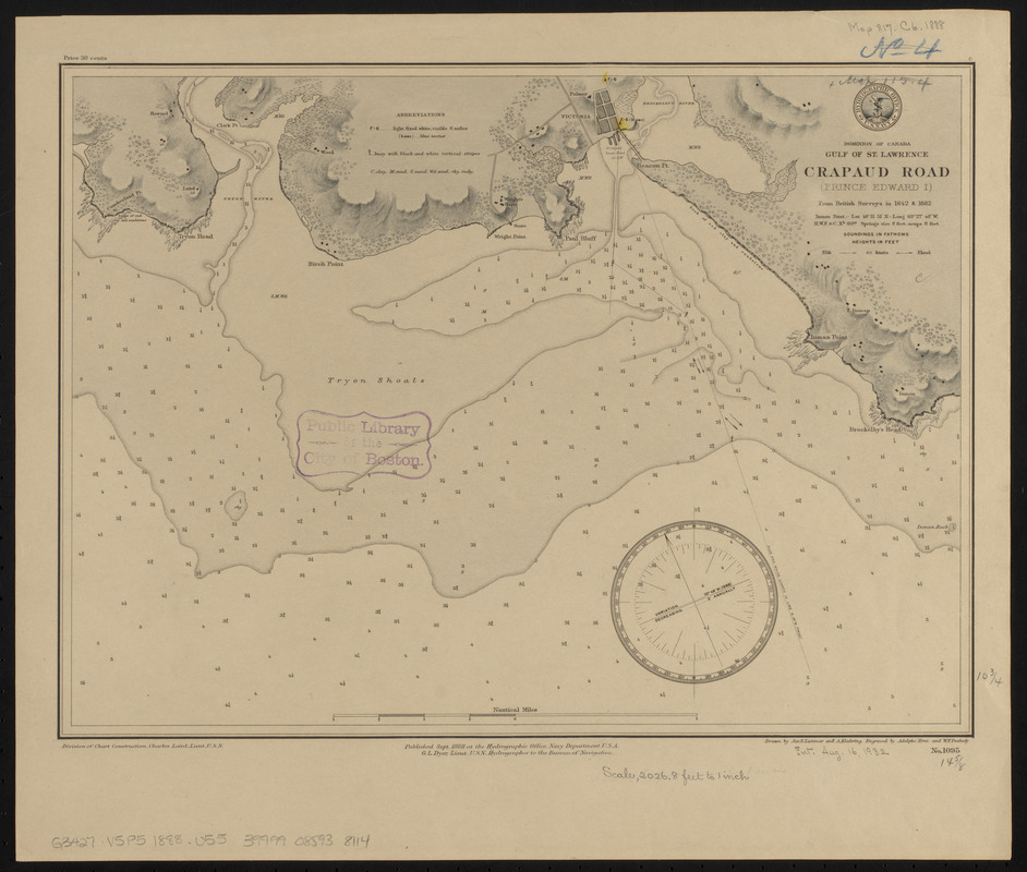
Dominion of Canada, Gulf of St. Lawrence, Crapaud Road (Prince Edward I.) : from British surveys in 1842 & 1882
Item Information
- Title:
- Dominion of Canada, Gulf of St. Lawrence, Crapaud Road (Prince Edward I.) : from British surveys in 1842 & 1882
- Title (alt.):
-
Crapaud Road (Prince Edward I.)
- Issuing body:
- United States. Hydrographic Office
- Engraver:
- Erni, A. (Adolphe)
- Draftsman:
- Klakring, A. (Alfred)
- Draftsman:
- Latimer, J. S. (Joseph S.)
- Engraver:
- Peabody, W. F. (William F.)
- Name on Item:
-
drawn by Jos. S. Latimer and A. Klakring ; engraved by Adolphe Erni and W.E. Peabody
- Date:
-
1888
- Format:
-
Maps/Atlases
- Location:
-
Boston Public Library
Norman B. Leventhal Map & Education Center - Collection (local):
-
Norman B. Leventhal Map & Education Center Collection
- Subjects:
-
Nautical charts--Prince Edward Island--Victoria Harbour
Nautical charts--Prince Edward Island--Tryon Shoals
Victoria Harbour (P.E.I.)--Maps
Tryon Shoals (P.E.I.)--Maps
- Places:
-
CanadaProvince of Prince Edward Island (province)Victoria
Tryon Shoals
- Extent:
- 1 map : hand colored ; 28 x 38 cm
- Terms of Use:
-
No known copyright restrictions.
No known restrictions on use.
- Publisher:
-
[Washington, D.C.] :
Hydrographic Office
- Scale:
-
Scale approximately 1:24,500
- Language:
-
English
- Notes:
-
Relief shown by shading and spot heights. Depths shown by soundings.
- Identifier:
-
06_01_015575
- Call #:
-
G9096.P5 svar .U55
- Barcode:
-
39999085938114


