West Indies, ports on the north coast of Cuba : from Spanish government surveys corrected to 1883
Item Information
- Title:
- West Indies, ports on the north coast of Cuba : from Spanish government surveys corrected to 1883
- Title (alt.):
-
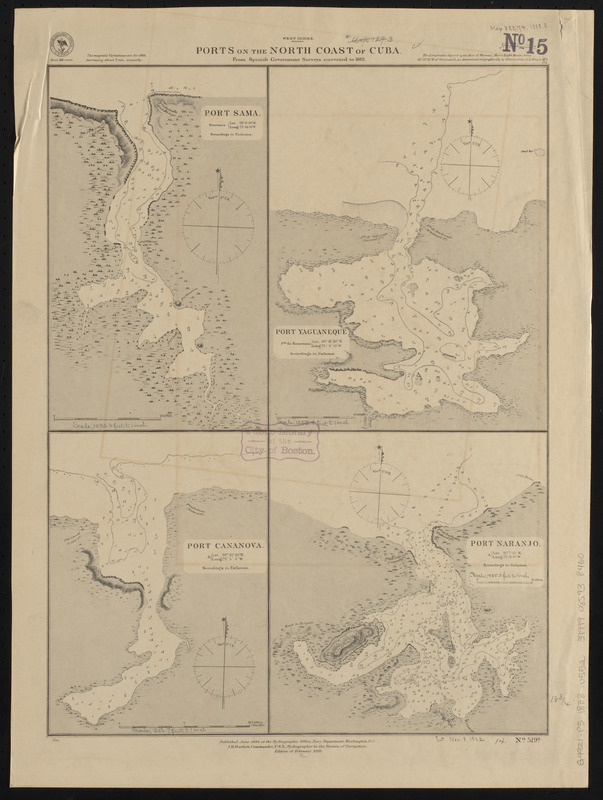
Ports on the north coast of Cuba
Port Sama
Port Yaguaneque
Port Cananova
Port Naranjo
- Issuing body:
- United States. Hydrographic Office
- Date:
-
1888
- Format:
-
Maps/Atlases
- Location:
-
Boston Public Library
Norman B. Leventhal Map & Education Center - Collection (local):
-
Norman B. Leventhal Map & Education Center Collection
- Subjects:
-
Nautical charts--Cuba--Samá Bay
Nautical charts--Cuba--Yaguaneque Bay
Nautical charts--Cuba--Cananova Bay
Nautical charts--Cuba--Naranjo Bay
Samá Bay (Cuba)--Maps
Yaguaneque Bay (Cuba)--Maps
Cananova Bay (Cuba)--Maps
Naranjo Bay (Cuba)--Maps
- Places:
-
CubaHolguín (province)
Bahía de Samá
Bahía de Yaguaneque
Bahía de Cananova
Bahía de Naranjo
- Extent:
- 4 maps on 1 sheet ; 48 x 36 cm
- Terms of Use:
-
No known copyright restrictions.
No known restrictions on use.
- Publisher:
-
Washington, D.C. :
Hydrographic Office
- Edition:
- Edition of February 1888
- Scale:
-
Scale approximately 1:12,000
Scale approximately 1:16,400
Scale approximately 1:19,800
Scale approximately 1:23,500
- Language:
-
English
- Table of Contents:
-
Port Sama
Port Yaguaneque
Port Cananova
Port Naranjo.
- Notes:
-
Relief shown by hachures. Depths shown by soundings and isolines.
- Identifier:
-
06_01_015655
- Call #:
-
G9096.P5 svar .U55
- Barcode:
-
39999085938460


