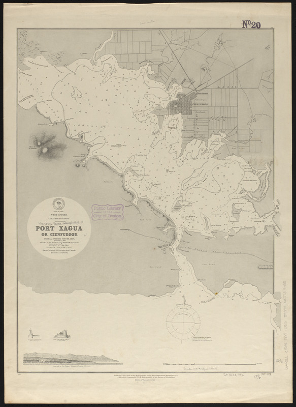
West Indies, Cuba--South Coast, Port Xagua or Cienfuegos : from a Spanish survey, 1836, corrected to 1886
Item Information
- Title:
- West Indies, Cuba--South Coast, Port Xagua or Cienfuegos : from a Spanish survey, 1836, corrected to 1886
- Title (alt.):
-
Port Xagua or Cienfuegos
- Issuing body:
- United States. Hydrographic Office
- Date:
-
1888
- Format:
-
Maps/Atlases
- Location:
-
Boston Public Library
Norman B. Leventhal Map & Education Center - Collection (local):
-
Norman B. Leventhal Map & Education Center Collection
- Subjects:
-
Nautical charts--Cuba--Cienfuegos Bay
Cienfuegos Bay (Cuba)--Maps
- Places:
-
CubaCienfuegos (province)Cienfuegos, Bahía de (bay)
- Extent:
- 1 map : hand colored ; 61 x 47 cm
- Terms of Use:
-
No known copyright restrictions.
No known restrictions on use.
- Publisher:
-
Washington, D.C. :
Hydrographic Office
- Edition:
- Edition of September 1888
- Scale:
-
Scale approximately 1:34,000
- Language:
-
English
- Notes:
-
Relief shown by hachures. Depths shown by soundings and isolines.
Includes 2 illustrations and 1 coastal view.
- Identifier:
-
06_01_015671
- Call #:
-
G9096.P5 svar .U55
- Barcode:
-
39999085939435


