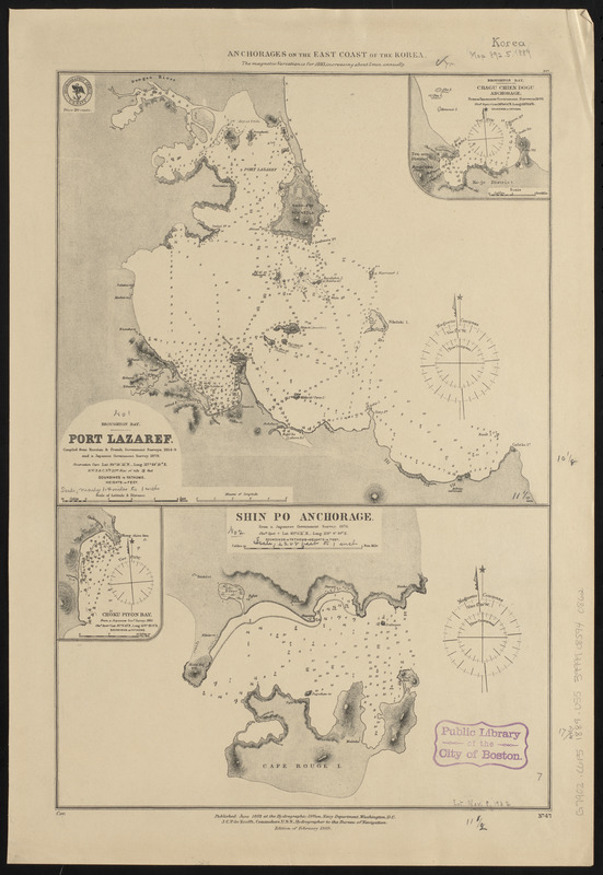
Anchorages on the east coast of the Korea
Item Information
- Title:
- Anchorages on the east coast of the Korea
- Issuing body:
- United States. Hydrographic Office
- Date:
-
1889
- Format:
-
Maps/Atlases
- Location:
-
Boston Public Library
Norman B. Leventhal Map & Education Center - Collection (local):
-
Norman B. Leventhal Map & Education Center Collection
- Subjects:
-
Harbors--Korea (North)--Sinp'o-si--Maps
Nautical charts--Korea (North)--Songjŏn Bay
Nautical charts--Korea (North)--Kŭmya Bay
Nautical charts--Korea (North)--Sinp'o Harbor
Songjŏn Bay (Korea)--Maps
Kŭmya Bay (Korea)--Maps
Sinp'o Harbor (Korea)--Maps
Sinp'o-si (Korea)--Maps
- Places:
-
North KoreaHamnam (province)Sinpo
Songjŏn-man
Yung Hing Bay
- Extent:
- 2 maps on 1 sheet ; 45 x 30 cm
- Terms of Use:
-
No known copyright restrictions.
No known restrictions on use.
- Publisher:
-
Washington, D.C. :
Hydrographic Office
- Edition:
- Edition of February 1889
- Scale:
-
Scale approximately 1:52,000
Scale approximately 1:135,000
- Language:
-
English
- Table of Contents:
-
Port Lazaref
Shin Po Anchorage.
- Notes:
-
Relief shown by hachures. Depths shown by soundings.
Insets: Chagu Chien Dogu Anchorage -- Choku Piyon Bay.
- Identifier:
-
06_01_015914
- Call #:
-
G9096.P5 svar .U55
- Barcode:
-
39999085940862


