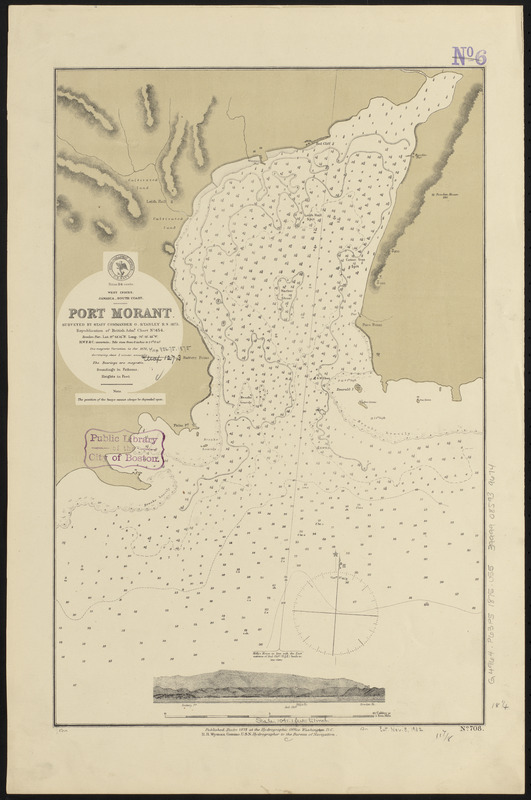
West Indies, Jamaica--south coast, Port Morant : surveyed by Staff Commander G. Stanley, R.N. 1873 ; republication of British Admy. chart no. 454
Item Information
- Title:
- West Indies, Jamaica--south coast, Port Morant : surveyed by Staff Commander G. Stanley, R.N. 1873 ; republication of British Admy. chart no. 454
- Title (alt.):
-
Port Morant
- Issuing body:
- United States. Hydrographic Office
- Date:
-
1875
- Format:
-
Maps/Atlases
- Location:
-
Boston Public Library
Norman B. Leventhal Map & Education Center - Collection (local):
-
Norman B. Leventhal Map & Education Center Collection
- Subjects:
-
Harbors--Jamaica--Port Morant--Maps
Nautical charts--Jamaica--Port Morant
Port Morant (Jamaica)--Maps
- Places:
-
JamaicaSaint Thomas (county)Port Morant
- Extent:
- 1 map ; 47 x 31 cm
- Terms of Use:
-
No known copyright restrictions.
No known restrictions on use.
- Publisher:
-
Washington, D.C. :
Hydrographic Office
- Scale:
-
Scale approximately 1:12,500
- Language:
-
English
- Notes:
-
Relief shown by hachures and spot heights. Depths shown by soundings and isolines.
Includes coastal view.
- Identifier:
-
06_01_015774
- Call #:
-
G9096.P5 svar .U55
- Barcode:
-
39999085939674


