Global map for global war and global peace


Item Information
- Title:
- Global map for global war and global peace
- Title (alt.):
-
World of the airplane
- Publisher:
- Aluminum Company of America
- Cartographer:
- Petruccelli, A.
- Name on Item:
-
A. Petruccelli
- Date:
-
1943
- Format:
-
Maps/Atlases
- Location:
-
Boston Public Library
Norman B. Leventhal Map & Education Center - Collection (local):
-
Norman B. Leventhal Map & Education Center Collection
- Subjects:
-
Airways--Maps
World War, 1939-1945--Maps
Aeronautics, Military--Maps
United States--Armed Forces--Insignia
- Places:
-
World
- Extent:
- 1 map : color ; 51 x 45 cm, on sheet 61 x 85 cm, folded to 21 x 15 cm
- Terms of Use:
-
No known copyright restrictions.
No known restrictions on use.
- Publisher:
-
New York :
Alcoa Map Dept.
- Scale:
-
Scale approximately 1:63,360,000
- Projection:
- Azimuthal equidistant projection
- Language:
-
English
- Notes:
-
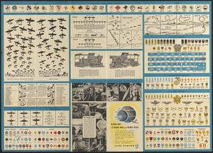
Relief shown by shading.
Panel title.
Includes illustrations, distance table and text about projections, latitude, longitude, distances, the aircraft industry and aluminum.
Illustrations of aircraft markings of majors countries in border.
On verso: text, illustrations, U.S. military insignia and plane profiles.
"All data included were the most complete available on October 15, 1943."
- Identifier:
-
06_01_016162
06_01_016189
- Call #:
-
G3201.P62 1943 .A4
- Barcode:
-
39999085944906


