Great circle airways
Item Information
- Title:
- Great circle airways
- Title (uniform):
-
Fortune
- Description:
-
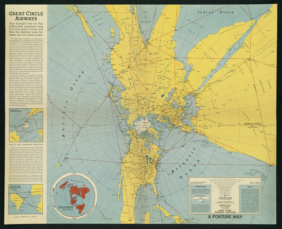
A reoccurring theme in the work of mid-20th century cartographer Richard Harrison was the close proximity of North America to the Eurasian land mass by crossing over the North Pole. This was an important and urgent message to convey to the American public at the beginning of World War II. Many believed that the apparent isolation offered by the Atlantic and Pacific Oceans, as portrayed on most conventional maps, provided security from the military conflicts in central Europe and eastern Asia. By using a map projection centered on the North Pole, Harrison demonstrated that the shortest distance from the major North American cities to Europe and Asia was across Canada and the northern polar region. With the advent of the airplane during the first half of the 20th century, attack from the North by air appeared to be a real threat. Prior to the 20th century few maps paid much attention to the polar regions. Since these areas were poorly explored and were not practical for sea navigation, they were often cut off by the top or bottom margins of the map. Consequently few people considered travel across the north polar regions a viable alternative. In this map, Harrison used an unusual projection, called gnomic. Except at the center, it greatly distorts shape, area, and scale. It is used primarily for navigation (sea or air) because a great circle (the shortest distance on a globe) appears as a straight line.
- Creator:
- Harrison, Richard Edes.
- Name on Item:
-
drawn by Richard Edes Harrison ; assisted by Marjorie K. Ullrich.
- Date:
-
[ca. 1943]
- Format:
-
Maps/Atlases
- Location:
-
Boston Public Library
Norman B. Leventhal Map & Education Center - Collection (local):
-
Norman B. Leventhal Map & Education Center Collection
- Subjects:
-
World maps
Airways--Maps
Northern Hemisphere--Maps
- Places:
-
World
- Extent:
- 1 map : col. ; 51 x 63 cm.
- Terms of Use:
-
Rights status not evaluated.
This work is licensed for use under a Creative Commons Attribution Non-Commercial No Derivatives License (CC BY-NC-ND).

- Publisher:
-
New York :
Time, Inc.
- Scale:
-
Scale: 1:81,000,000 at point of tangency ;
- Language:
-
English
- Notes:
-
Supplement to Fortune, May, 1943.
"A Fortune map."
Text at margins.
Insets: South Polar gnomonic chart -- South Atlantic gnomonic chart -- North Polar azimuthal equidistant projection.
Exhibited in “Journeys of the Imagination,” at the Boston Public Library, Boston, MA, April - August 2006. MB (BRL)
- Identifier:
-
05_01_000222
- Call #:
-
G3211.P62 1943 .H3
- Barcode:
-
39999052509708


