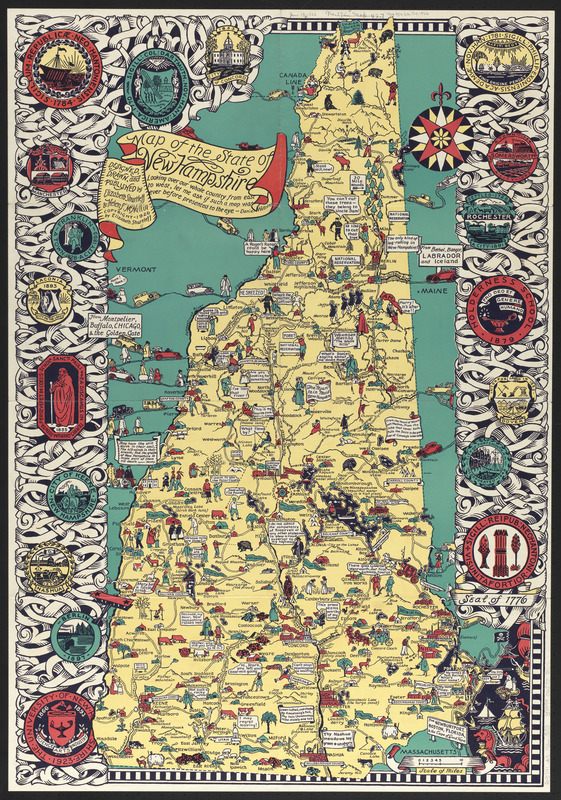
Map of the state of New Hampshire : looking over our whole country from east to west, let me ask if such a map was ever before presented to the eye - Daniel Webster
Item Information
- Title:
- Map of the state of New Hampshire : looking over our whole country from east to west, let me ask if such a map was ever before presented to the eye - Daniel Webster
- Artist:
- Shurtleff, Elizabeth, 1890-
- Publisher:
- Shurtleff, Elizabeth, 1890-
- Artist:
- McMillin, Helen F.
- Publisher:
- McMillin, Helen F.
- Name on Item:
-
designed, drawn and published by Elizabeth Shurtleff & Helen F. McMillin
- Date:
-
1926
- Format:
-
Maps/Atlases
- Location:
-
Boston Public Library
Norman B. Leventhal Map & Education Center - Collection (local):
-
Norman B. Leventhal Map & Education Center Collection
- Subjects:
-
New Hampshire--History--Maps
New Hampshire--Humor--Maps
- Places:
-
New Hampshire
- Extent:
- 1 map : color ; 84 x 59 cm, folded in envelope 23 x 32 cm
- Terms of Use:
-
No known copyright restrictions.
No known restrictions on use.
- Publisher:
-
[Boston, Massachusetts] :
Elizabeth Shurtleff & Helen F. Mcmillian
- Scale:
-
Scale approximately 1:345,000
- Language:
-
English
- Notes:
-
Pictorial map that includes humorous and historical drawings and references.
In margins: color illustrations of various emblems of towns and organizations.
Contains pictures illustrating matters of local interest.
- Identifier:
-
06_01_014758
- Call #:
-
G3741.A5 1926 .S58
- Barcode:
-
39999065705467


