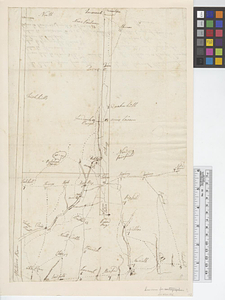
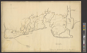
Part of the modern county of Fairfield : copied for the adjutant general
This map is also available in American Revolutionary Geographies Online (ARGO), a collections portal especially built for material relating to the American Revolutionary War Era. Visit ARGO to learn more about this item and explore the historical geography of North America in the late eighteenth century.
Item Information
- Title:
- Part of the modern county of Fairfield : copied for the adjutant general
- Creator:
- Skinner, Andrew (Geographer)
- Name on Item:
-
by Andrew Skinner
- Date:
-
[1770–1779]
- Format:
-
Maps/Atlases
- Genre:
-
Manuscript maps
- Location:
- William L. Clements Library
- Collection (local):
-
William L. Clements Library Collection
- Subjects:
-
Fairfield County (Conn.)--Maps
- Places:
-
ConnecticutFairfield (county)
- Extent:
- 1 ms. map : col. ; 40.1 x 59.8 cm.
- Terms of Use:
-
The University of Michigan Library provides access to these materials for educational and research purposes. These materials may be under copyright. If you decide to use any of these materials, you are responsible for making your own legal assessment and securing any necessary permission. If you have questions about the collection, please contact the William L. Clements Library.
Contact host institution for more information.
- Scale:
-
Scale 1:35,000.
- Language:
-
English
- Catalog Record:
-
Catalog record
- Notes:
-
Finished, colored, topographical map of the Connecticut coast from McKensey's Point to Milford Beach and extending back from the coast about four miles.
Towns and individual farms are distinguished by the figures of churches and houses, with most of the latter identified by the name of the owner.
Clinton Map 110.
- Notes (date):
-
This date is inferred.
- Identifier:
-
8288
- Barcode:
-
B2848766