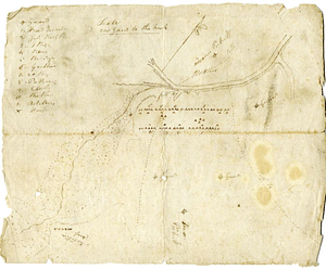
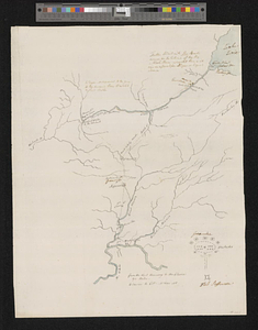
Plan of St. Clairs battle ground

This map is also available in American Revolutionary Geographies Online (ARGO), a collections portal especially built for material relating to the American Revolutionary War Era. Visit ARGO to learn more about this item and explore the historical geography of North America in the late eighteenth century.
Item Information
- Title:
- Plan of St. Clairs battle ground
- Title (alt.):
-
No 2 Plan of battle of 4 Nov
- Creator:
- Bedinger, George Michael, 1756-1843
- Name on Item:
-
by Majr Genl. Bedinger
- Date:
-
[1791]
- Format:
-
Maps/Atlases
- Genre:
-
Manuscript maps
- Location:
- William L. Clements Library
- Collection (local):
-
William L. Clements Library Collection
- Subjects:
-
St Clair's Defeat, Ohio, 1791--Maps
St Clair's Campaign, 1791--Maps
Ohio--Maps
- Places:
-
Ohio
- Extent:
- 1 ms. map ; 30.5 x 18.5 cm.
- Terms of Use:
-
The University of Michigan Library provides access to these materials for educational and research purposes. These materials may be under copyright. If you decide to use any of these materials, you are responsible for making your own legal assessment and securing any necessary permission. If you have questions about the collection, please contact the William L. Clements Library.
Contact host institution for more information.
- Scale:
-
Scale indeterminate.
- Language:
-
English
- Catalog Record:
-
Catalog record
- Notes:
-
Finished pen and ink plan of St. Clair's defeat of November 4, 1791, showing original positions of named military units, positions of Indian attackers, and direction of American retreat.
Table of references identifies symbols used on map.
Above map is written: The haste I am in will not give me time fully to explain this plan of the action of the 4th Nov.
Both titles, in different hands, from verso.
- Notes (date):
-
This date is inferred.
- Identifier:
-
539
- Barcode:
-
B3463448