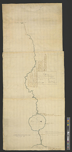
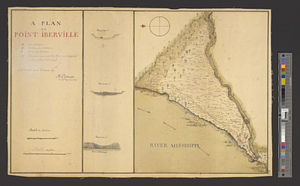
A plan of Point Ibberville
This map is also available in American Revolutionary Geographies Online (ARGO), a collections portal especially built for material relating to the American Revolutionary War Era. Visit ARGO to learn more about this item and explore the historical geography of North America in the late eighteenth century.
Item Information
- Title:
- A plan of Point Ibberville
- Creator:
- Pittman, Philip, active 1760-1770
- Name on Item:
-
survey'd and drawn by Ph: Pittman lieut. 15th Regt. assistt. engr.
- Date:
-
[1765]
- Format:
-
Maps/Atlases
- Genre:
-
Manuscript maps
- Location:
- William L. Clements Library
- Collection (local):
-
William L. Clements Library Collection
- Subjects:
-
Fort Bute (La.)--Maps
Manchac, Bayou (La.)--Maps
- Places:
-
LouisianaManchac, Bayou (stream)
Fort Bute (historical)
- Extent:
- 1 ms. map : col. ; 31.6 x 47.7 cm.
- Terms of Use:
-
The University of Michigan Library provides access to these materials for educational and research purposes. These materials may be under copyright. If you decide to use any of these materials, you are responsible for making your own legal assessment and securing any necessary permission. If you have questions about the collection, please contact the William L. Clements Library.
Contact host institution for more information.
- Scale:
-
Scale 1:2,400.
- Language:
-
English
- Catalog Record:
-
Catalog record
- Notes:
-
Finished, colored topographical map of Fort Bute or Manchac Post.
Includes three sections of the river Iberville.
Table of references identifies major features and buildings.
This map is a duplicate of the other of the same title from the Gage Papers (Clements Library) differing in some details, most notably that the lettered references have not been indicated on the map itself.
- Notes (date):
-
This date is inferred.
- Identifier:
-
1669
- Barcode:
-
B3314706