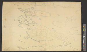
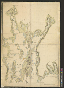
Narragansett Bay and the surrounding shores
This map is also available in American Revolutionary Geographies Online (ARGO), a collections portal especially built for material relating to the American Revolutionary War Era. Visit ARGO to learn more about this item and explore the historical geography of North America in the late eighteenth century.
Item Information
- Title:
- Narragansett Bay and the surrounding shores
- Creator:
- Wheeler, Thomas (Surveyor)
- Date:
-
[1770–1779]
- Format:
-
Maps/Atlases
- Genre:
-
Manuscript maps
- Location:
- William L. Clements Library
- Collection (local):
-
William L. Clements Library Collection
- Subjects:
-
Narragansett Bay (R.I.)--Maps
Newport County (R.I.)--Maps
- Places:
-
Rhode IslandBristol (county)Narragansett Bay
Rhode IslandNewport (county)
- Extent:
- 1 ms. map : col. ; 102.5 x 75 cm.
- Terms of Use:
-
The University of Michigan Library provides access to these materials for educational and research purposes. These materials may be under copyright. If you decide to use any of these materials, you are responsible for making your own legal assessment and securing any necessary permission. If you have questions about the collection, please contact the William L. Clements Library.
Contact host institution for more information.
- Scale:
-
Scale 1:50,000.
- Language:
-
English
- Catalog Record:
-
Catalog record
- Notes:
-
Signed within neat line at lower right: T Wheeler.
Finished, colored, topographical map showing the bay and its surrounding land from Long Island Sound to some distance up the Taunton and Providence rivers.
Principal towns of the area are shown.
Clinton Maps 58.
- Notes (date):
-
This date is inferred.
- Identifier:
-
826
- Barcode:
-
B2851024