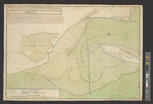
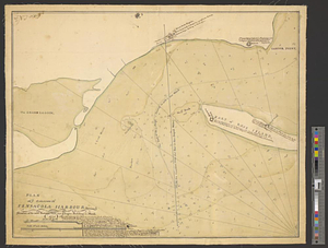
Plan of ye entrance of Pensacola harbour shewing ye situation of the new batteries laid out & begun building in March 1771
This map is also available in American Revolutionary Geographies Online (ARGO), a collections portal especially built for material relating to the American Revolutionary War Era. Visit ARGO to learn more about this item and explore the historical geography of North America in the late eighteenth century.
Item Information
- Title:
- Plan of ye entrance of Pensacola harbour shewing ye situation of the new batteries laid out & begun building in March 1771
- Contributor:
- Brasier, William
- Creator:
- Sowers, Thomas
- Date:
-
1771
- Format:
-
Maps/Atlases
- Genre:
-
Manuscript maps
- Location:
- William L. Clements Library
- Collection (local):
-
William L. Clements Library Collection
- Subjects:
-
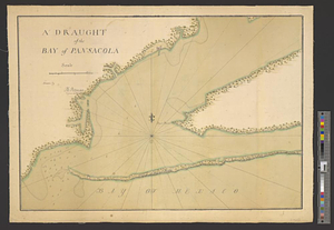
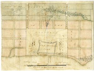
Pensacola (Fla.)--Maps
Pensacola Bay (Fla.)--Maps
- Places:
-
FloridaEscambia (county)Pensacola
FloridaPensacola Bay
- Extent:
- 1 ms. map : col. ; 45.8 x 55.5 cm.
- Terms of Use:
-
The University of Michigan Library provides access to these materials for educational and research purposes. These materials may be under copyright. If you decide to use any of these materials, you are responsible for making your own legal assessment and securing any necessary permission. If you have questions about the collection, please contact the William L. Clements Library.
Contact host institution for more information.
- Scale:
-
Scale 1:16,200.
- Language:
-
English
- Catalog Record:
-
Catalog record
- Notes:
-
Map executed in the style of Thomas Sowers, who was the engineer in charge of building the new fortifications at Pensacola.
Finished, colored chart of part of the harbor showing soundings and shallows.
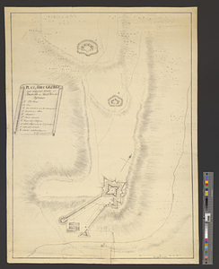
Plans show details of the fort at Red Cliffs and batteries and forts on the mainland and Rose Island with notations describing three new batteries.
- Identifier:
-
8325
- Barcode:
-
B2495162