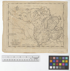
Map of the middle states of America : comprehends New-York, New-Jersey, Pennsylvania, Delaware, and the territory N:W: of Ohio

This map is also available in American Revolutionary Geographies Online (ARGO), a collections portal especially built for material relating to the American Revolutionary War Era. Visit ARGO to learn more about this item and explore the historical geography of North America in the late eighteenth century.
Item Information
- Title:
- Map of the middle states of America : comprehends New-York, New-Jersey, Pennsylvania, Delaware, and the territory N:W: of Ohio
- Title (alt.):
-
Supplement to the state of New York
- Contributor:
- Symonds, H. D. (Henry Delahoy)
- Creator:
- Russell, John, active 1733-1795
- Name on Item:
-
by J. Russell
- Date:
-
December 13, 1794
- Format:
-
Maps/Atlases
- Location:
- William L. Clements Library
- Collection (local):
-
William L. Clements Library Collection
- Subjects:
-
Middle Atlantic States--Maps
Northwest, Old--Maps
- Places:
-
Middle Atlantic (area)
East North Central states (area)
- Extent:
- 1 map : outline col. ; 36.7 x 47 cm
- Terms of Use:
-
The University of Michigan Library provides access to these materials for educational and research purposes. These materials may be under copyright. If you decide to use any of these materials, you are responsible for making your own legal assessment and securing any necessary permission. If you have questions about the collection, please contact the William L. Clements Library.
Contact host institution for more information.
- Publisher:
-
London :
H.D. Symonds, no. 20 Paternoster Row
- Scale:
-
Scale 1:2,100,000.
- Language:
-
English
- Catalog Record:
-
Catalog record
- Notes:
-
Inset shows Long Island.
Individual states outlined in color.
- Identifier:
-
1840
- Barcode:
-
B1937384