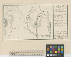
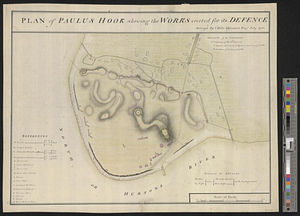
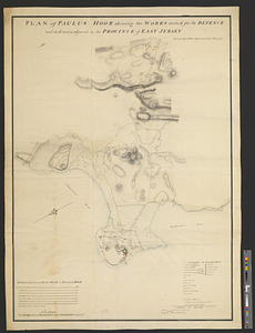
Plan of Paulus Hook shewing the works erected for its defence and the country adjacent in the province of East Jersey
This map is also available in American Revolutionary Geographies Online (ARGO), a collections portal especially built for material relating to the American Revolutionary War Era. Visit ARGO to learn more about this item and explore the historical geography of North America in the late eighteenth century.
Item Information
- Title:
- Plan of Paulus Hook shewing the works erected for its defence and the country adjacent in the province of East Jersey
- Contributor:
- Clinton, Henry, Sir, 1738?-1795
- Creator:
- Hills, John, active 1777-1819
- Name on Item:
-
surveyd by I. Hills, assistant engr. July 1781
- Date:
-
1781
- Format:
-
Maps/Atlases
- Genre:
-
Manuscript maps
- Location:
- William L. Clements Library
- Collection (local):
-
William L. Clements Library Collection
- Subjects:
-
Paulus Hook (N.J.)--Maps
Bergen (Jersey City, N.J.)--Maps
United States--History--Revolution, 1775-1783--Maps
- Places:
-
New JerseyHudson (county)Jersey City
- Extent:
- 1 ms. map : col. ; 92.6 x 69.8 cm.
- Terms of Use:
-
The University of Michigan Library provides access to these materials for educational and research purposes. These materials may be under copyright. If you decide to use any of these materials, you are responsible for making your own legal assessment and securing any necessary permission. If you have questions about the collection, please contact the William L. Clements Library.
Contact host institution for more information.
- Scale:
-
Scale 1:2,760.
- Language:
-
English
- Catalog Record:
-
Catalog record
- Notes:
-
Finished, colored, topographical map showing the fortifications of Paulus Hook and features of the immediate vicinity, including the center of Bergen town.
Tables of reference identify buildings and fortifications, distances from the flagstaff to various nearby points, and a list of signals to be made if the post is attacked.
Initialed on verso by Sir Henry Clinton.
Clinton Maps 218.
- Identifier:
-
8659
- Barcode:
-
B2668377