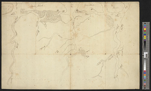
A plan of St. Mary's Harbour in the province of East Florida with the proposed post for the defence of it and the inland navigation to St. Jones [sic] River
![A plan of St. Mary's Harbour in the province of East Florida with the proposed post for the defence of it and the inland navigation to St. Jones [sic] River](https://bpldcassets.blob.core.windows.net/derivatives/metadata/commonwealth-oai:cv43st68h/image_thumbnail_300.jpg)
This map is also available in American Revolutionary Geographies Online (ARGO), a collections portal especially built for material relating to the American Revolutionary War Era. Visit ARGO to learn more about this item and explore the historical geography of North America in the late eighteenth century.
Item Information
- Title:
- A plan of St. Mary's Harbour in the province of East Florida with the proposed post for the defence of it and the inland navigation to St. Jones [sic] River
- Date:
-
[1770–1779]
- Format:
-
Maps/Atlases
- Genre:
-
Manuscript maps
- Location:
- William L. Clements Library
- Collection (local):
-
William L. Clements Library Collection
- Subjects:
-
Amelia Island (Fla.)--Maps
Cumberland Island (Ga.)--Maps
Saint Marys River (Ga. and Fla.)--Maps
United States--History--Revolution, 1775-1783--Maps
- Places:
-
FloridaNassau (county)Amelia Island (island)
GeorgiaCamden (county)Cumberland Island (island)
FloridaNassau (county)Little Saint Marys River
- Extent:
- 1 ms. map ; 57.2 x 46.4 cm.
- Terms of Use:
-
The University of Michigan Library provides access to these materials for educational and research purposes. These materials may be under copyright. If you decide to use any of these materials, you are responsible for making your own legal assessment and securing any necessary permission. If you have questions about the collection, please contact the William L. Clements Library.
Contact host institution for more information.
- Language:
-
English
- Catalog Record:
-
Catalog record
- Notes:
-
Finished, pen and ink map showing the site of the proposed fort and immediate vicinity.
Soundings are shown for the river and channel to the sea.
Table of references provides details of three redoubts on Cumberland Island.
Clinton Maps 335.
- Notes (date):
-
This date is inferred.
- Identifier:
-
8320
- Barcode:
-
B2494193