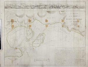
A plan of the harbors of Port Antonio in the island of Jamaica : survey'd 1770
This map is also available in American Revolutionary Geographies Online (ARGO), a collections portal especially built for material relating to the American Revolutionary War Era. Visit ARGO to learn more about this item and explore the historical geography of North America in the late eighteenth century.
Item Information
- Title:
- A plan of the harbors of Port Antonio in the island of Jamaica : survey'd 1770
- Title (alt.):
-
Appearance of the land about Port Antonio when Navy Island bears south west 5 or 6 miles distance
- Creator:
- Knatchbull, Charles
- Name on Item:
-
by Chas. Knatchbull
- Date:
-
1770
- Format:
-
Maps/Atlases
- Genre:
-
Manuscript maps
- Location:
- William L. Clements Library
- Collection (local):
-
William L. Clements Library Collection
- Subjects:
-
Port Antonio (Jamaica)--Maps
- Places:
-
JamaicaPortland (county)Port Antonio
- Extent:
- 1 ms. map : outline col. ; 42 x 53.5 cm.
- Terms of Use:
-
The University of Michigan Library provides access to these materials for educational and research purposes. These materials may be under copyright. If you decide to use any of these materials, you are responsible for making your own legal assessment and securing any necessary permission. If you have questions about the collection, please contact the William L. Clements Library.
Contact host institution for more information.
- Scale:
-
Scale ca. 1:60,000.
- Language:
-
English
- Catalog Record:
-
Catalog record
- Notes:
-
Pen and ink chart and topographical map of the harbor, with shore outlined in color.
Soundings in harbor and details on land include fortifications.
Table of references at upper left identifies major features and text block at lower right provides detailed directions for entering the harbor.
Inset is very detailed coastal profile that corresponds to the chart.
- Identifier:
-
1668
- Barcode:
-
B3301991


