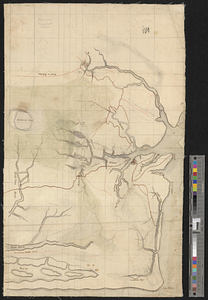
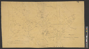
Plan of Princess Ann and Norfolk counties
This map is also available in American Revolutionary Geographies Online (ARGO), a collections portal especially built for material relating to the American Revolutionary War Era. Visit ARGO to learn more about this item and explore the historical geography of North America in the late eighteenth century.
Item Information
- Title:
- Plan of Princess Ann and Norfolk counties
- Date:
-
[ca. 1781]
- Format:
-
Maps/Atlases
- Genre:
-
Manuscript maps
- Location:
- William L. Clements Library
- Collection (local):
-
William L. Clements Library Collection
- Subjects:
-
Princess Anne County (Va.)--Maps
Norfolk County (Va.)--Maps
United States--History--Revolution, 1775-1783--Maps
- Places:
-
VirginiaVirginia Beach
VirginiaChesapeake
- Extent:
- 1 ms. map ; 52 x 86.5 cm.
- Terms of Use:
-
The University of Michigan Library provides access to these materials for educational and research purposes. These materials may be under copyright. If you decide to use any of these materials, you are responsible for making your own legal assessment and securing any necessary permission. If you have questions about the collection, please contact the William L. Clements Library.
Contact host institution for more information.
- Scale:
-
Scale ca. 1:190,080.
- Language:
-
English
- Catalog Record:
-
Catalog record
- Notes:
-
Finished, topographical, pen and ink map showing the primary roads, rivers, and towns, with the names of some plantation owners.
Shows Great Bridge and its fortifications in some detail.
Table of references identify places and events relating to the campaign of 1781.
Clinton Maps 267.
- Identifier:
-
626
- Barcode:
-
B2625258