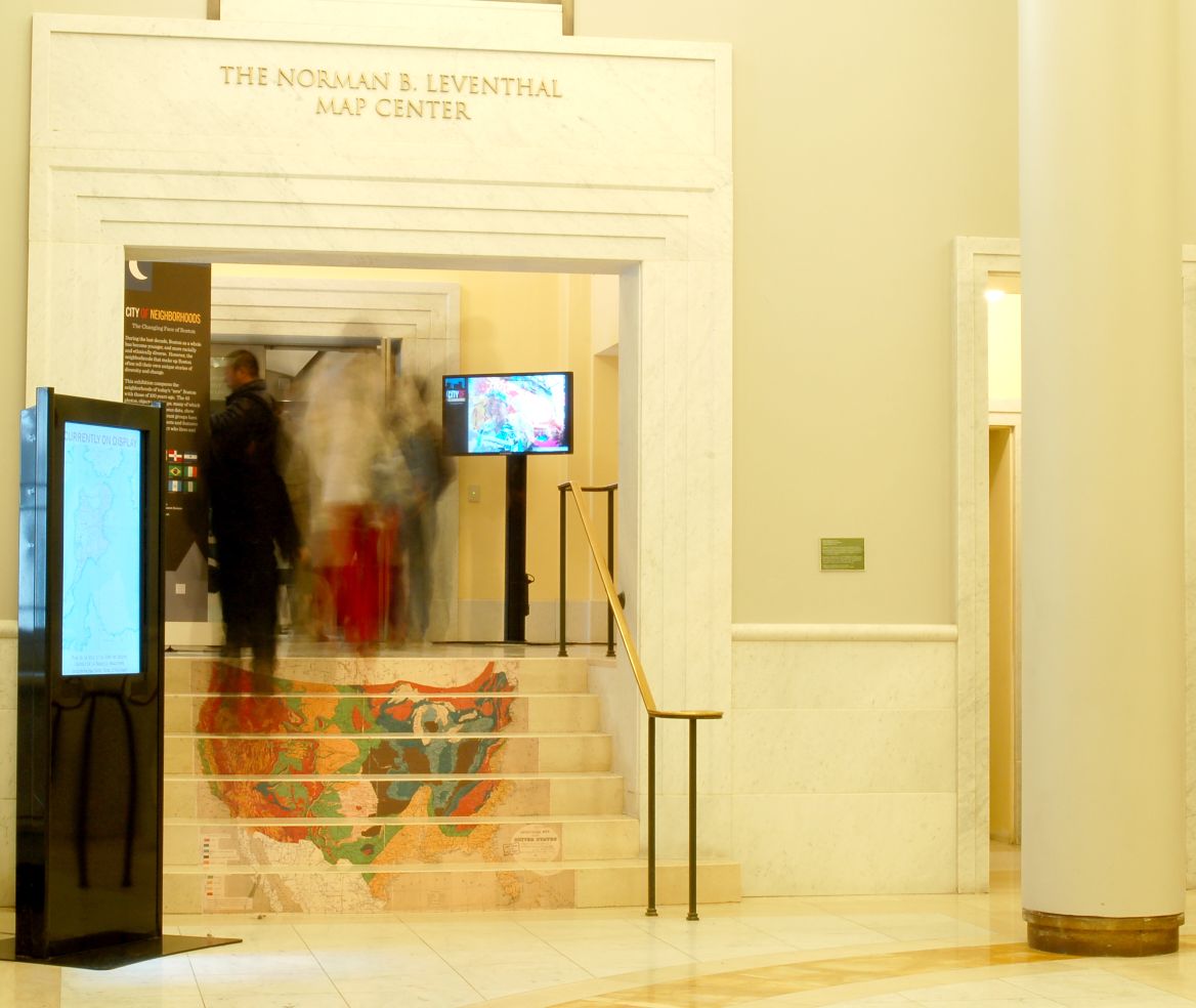
Introduction
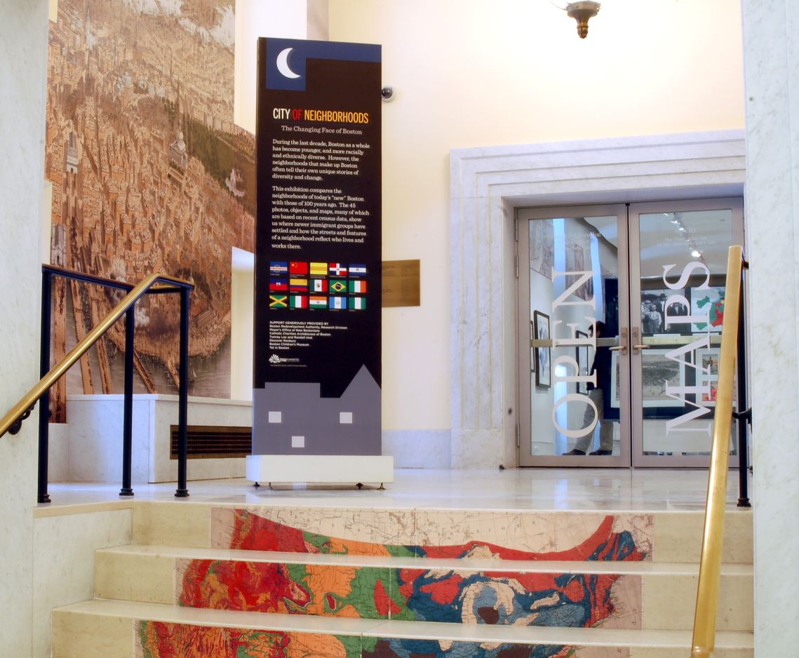
During the last decade, Boston as a whole has become younger, and more racially and ethnically diverse. However, the neighborhoods that make up Boston often tell their own unique stories of diversity and change.
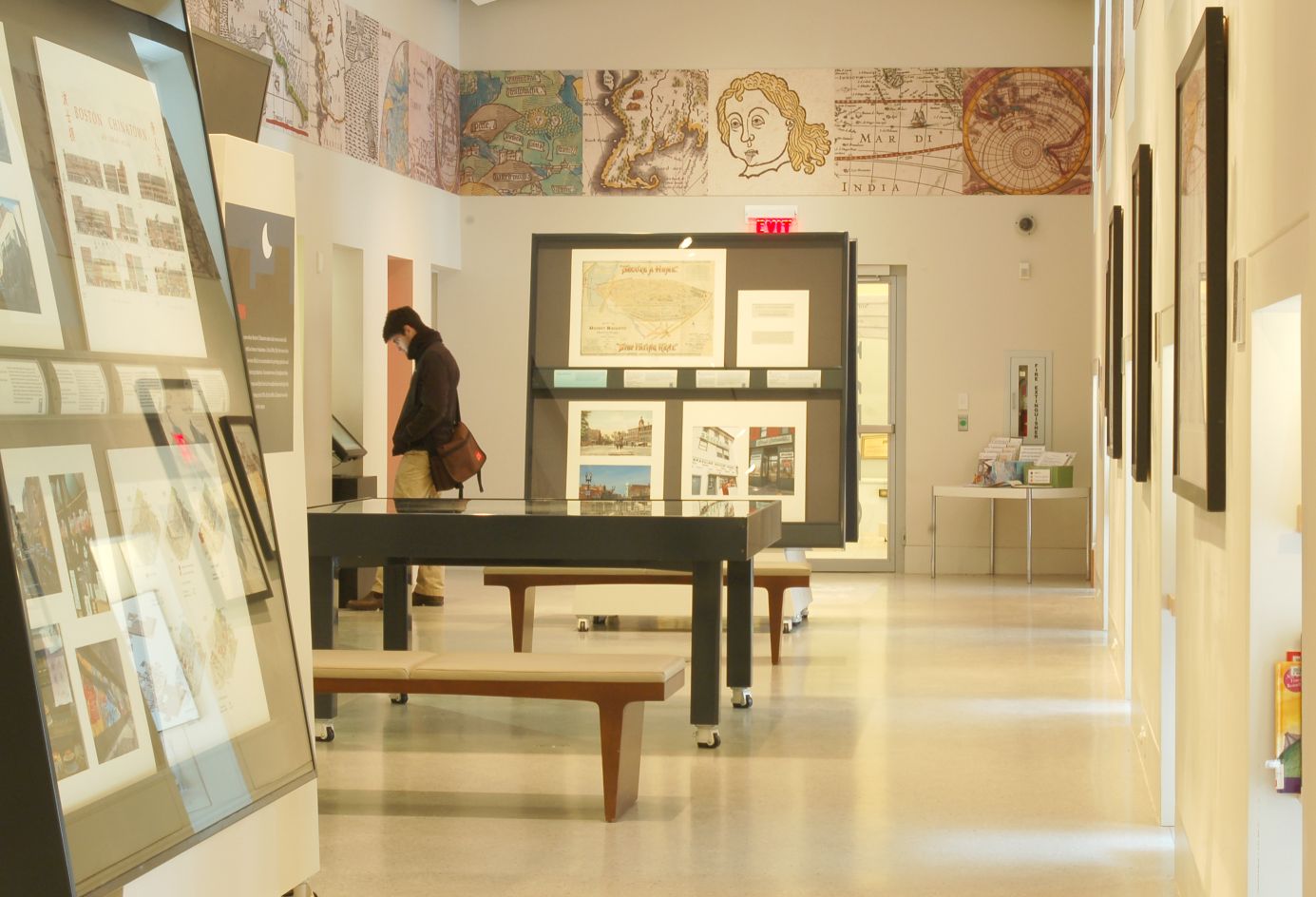
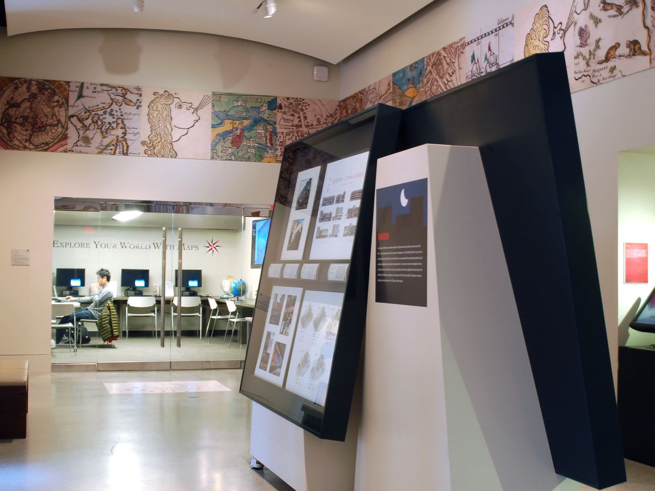
This exhibition compares the neighborhoods of today’s “new” Boston with those of 100 years ago. The 45 photos, objects, and maps, many of which are based on recent census data, show us where newer immigrant groups have settled and how the streets and features of a neighborhood reflect who lives and works there.
Durante la década pasada, Boston en conjunto se ha vuelto más joven y más diversa en lo racial y étnico. Sin embargo, las ciudades que componen Boston a menudo cuentan sus propias historias exclusivas de la diversidad y el cambio.
Esta exposición cuenta la historia de un “nuevo” Boston mirando a la ciudad en general y a las comunidades singulares de manera individual. Las 45 fotografías, objetos y mapas, muchos de los cuales están basados en los datos del censo reciente, nos muestran donde los nuevos grupos de inmigrantes se han establecido y cómo las calles y las características de una ciudad reflejan quién vive y trabaja allí.
Pandan dènye deseni an, Boston tout antye te vin plis jèn, plis divès rasyalman ak etnikman. Sepandan, katye yo ki konpoze Boston le pli souvan rakonte istwa inik pwòp pa yo sou divèsite ak chanjman.
Egzibisyon sa a rakonte istwa yon “nouvo” Boston nan gade vil la an jeneral epi katye endividyèl yo. 45 foto yo, objè, ak kat, anpil nan yo ki baze sou done resansman ki fèk fèt, montre nou Ki kote nouvo gwoup imigran etabli yo epi kijan lari yo ak karakteristik nan yon katye reflekte kilès ki abite epi travay la.
在过去的十年里, 波士顿已变成一个更族裔多元化和更年轻化的城市. 组成波士顿的各个城区都有它们独特的多元化和变化的故事.
这个展览通过查看整个城市以及各个城区, 讲述了一个“新”波士顿的故事. 这里一共有45张照片, 物件, 和地图, 其中有许多是根据最近的人口普查数据, 告诉我们较新的移民群体在哪儿定居, 通过城区的街道和特点反映出谁在哪里居住和工作.
Booklists
This program is funded in part by Mass Humanities, which receives support from the Massachusetts Cultural Council and is an affiliate of the National Endowment for the Humanities.
1. Boston and Massachusetts
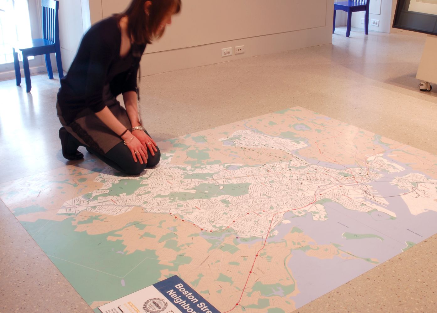
Boston Redevelopment Authority, Research Division, Office of Digital Cartography and GIS.
Boston Streets and Neighborhoods
Boston, 2013
Courtesy Boston Redevelopment Authority
This large map illustrates the general geography of Boston and its neighborhoods, highlighting such recognizable landmarks as T stops, roads, and parks. Created by the Boston Redevelopment Authority, the map provides a precise and easily readable depiction of the city. Formed in 1957, the Boston Redevelopment Authority is charged with the mission to plan neighborhoods, manage development, and encourage Boston’s growth. Since the mid-1980s their Office of Digital Cartography and GIS has used computer-based technology for map production and has supplied Boston and its residents with accurate, up-to-date maps for many different purposes.
El gran mapa a continuación ilustra la geografía general de Boston y sus ciudades, destacando señales tan reconocibles como los paraderos de la T, carreteras y parques. Creado por la Autoridad de Reurbanización de Boston, el mapa proporciona una representación precisa y fácilmente identificable de la ciudad. Formada en 1957, la Autoridad de Reurbanización de Boston está a cargo de la misión de planificar ciudades, dirigir el desarrollo y fomentar el crecimiento de Boston. Desde mediados de la década de 1980 su Oficina de Cartografía Digital y SIG ha utilizado la tecnología computarizada para la producción de mapas y ha suministrado a Boston y sus residentes mapas precisos y actualizados para muchos diversos propósitos.
Gwo kat jeyografik anba a ilistre jeyografi jeneral Boston ak katye li yo. Nan mete aksan sou referans ki rekonesab konsa tankou T stops, wout, ak plas piblik yo. Ki te kreye pa Boston Redevelopment Authority, kat jeyografik la founi yon ilistrasyon vil la ki presi epi fasil pou li. Fòme nan ane 1957, Boston Redevelopment Authority a te pote misyon pou planifye katye yo, jere devlopman, epi ankouraje agrandisman Boston. Depi nan mitan ane 1980 yo Office of Digital Cartography and GIS li yo te fè itilizasyon teknoloji ki baze sou odinatè pou pwodiksyon kat jeyografik epi te founi Boston ak rezidan li yo kat jeyografik ki egzat, ki ajou pou plizyè diferan rezon.
下面的大地图显示了波士顿市及其各个城区的布局, 地图标出能识别的地标, 例如地铁站, 道路, 和公园. 地图由波士顿重建局制作, 提供了一幅精确和易于阅读的城市画面. 成立于1957年, 波士顿重建局肩负规划社区, 管理发展, 和促进波士顿成长的使命. 自从80年代中期, 波士顿重建局数字制图与GIS办公室使用以计算机为基础的技术进行地图制作, 为波士顿及其居民提供准确的和最新的用于各种不同用途的地图.
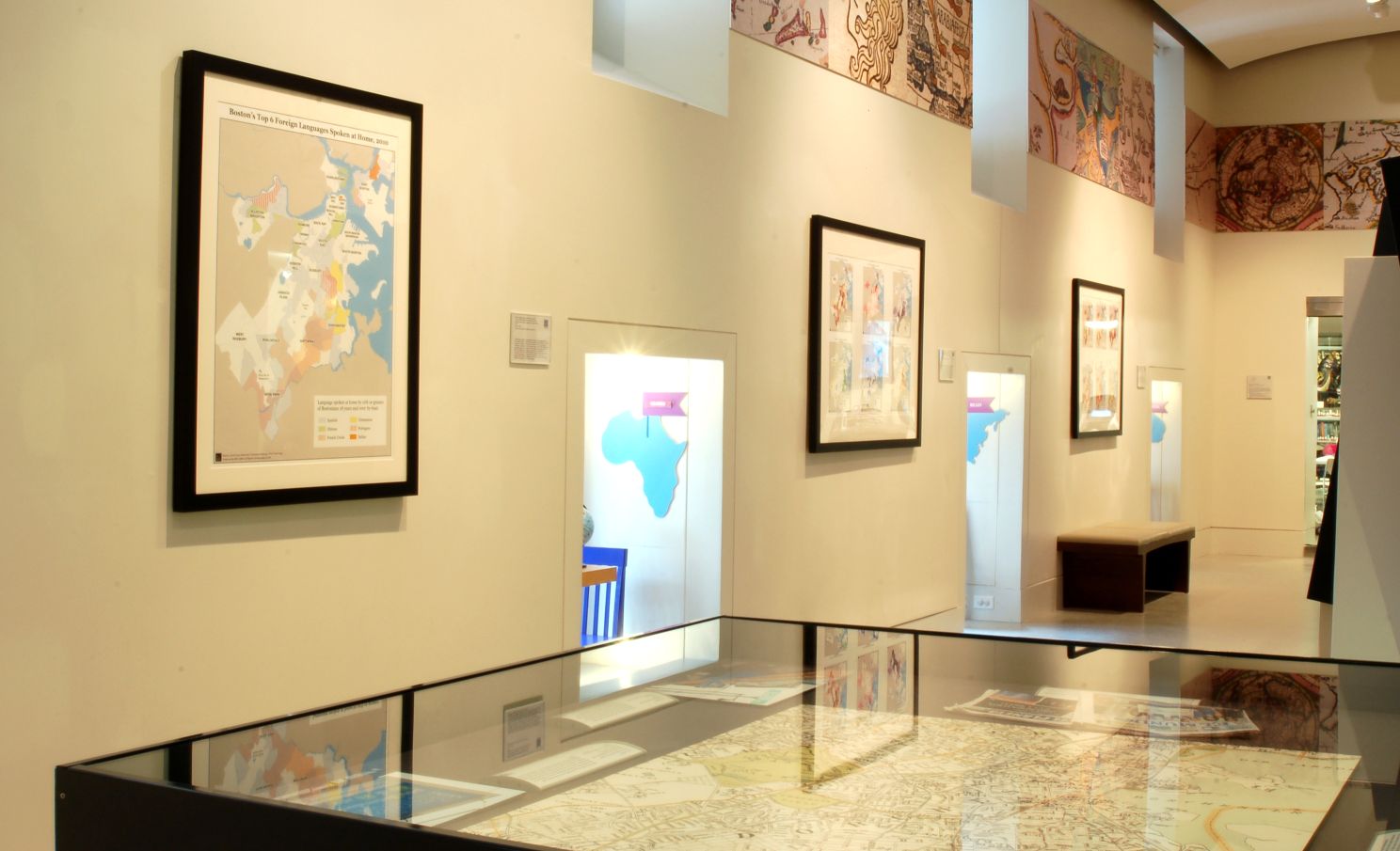
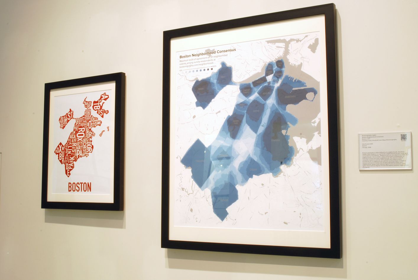
Bostonography.
Boston Neighborhood Consensus
Boston, 2013
Courtesy Andy Woodruff, Axis Maps/Bostonography
Boston’s geography is often defined by its neighborhoods. Residents readily claim allegiance to a particular neighborhood, but few rarely agree on its extent or boundaries. Displayed here is one depiction of the city’s neighborhoods. A map of consensus, based on a survey where people were asked to draw boundaries for 21 neighborhoods with the resulting shapes overlaid to measure amount of overlap and calculates agreement within each neighborhood. Darker blues indicate higher levels of consensus, while lighter blues indicate degrees of social discrepancy between neighborhood boundaries.
La geografía de Boston es a menudo definida por sus vecindades. Los residentes afirman fácilmente lealtad a una vecindad particular, pero pocos rara vez se ponen de acuerdo sobre su extensión o límites. Se exhiben aquí dos representaciones de las vecindades de la ciudad. Una es artística, usando diversos tamaños de tipografía o letras para localizar y nombrar vecindades. El otro es un mapa de consenso basado en una encuesta donde se pidió a la gente trazar los límites para 21 vecindades con las formas resultantes recubiertas para medir la cantidad de superposición y calcular el acuerdo dentro de cada vecindad. Los azules más oscuros indican mayores niveles de consenso, mientras que los azules más claros indican grados de discrepancia social entre los límites de la vecindad.
Jewografi Boston souvan defini pa katye li yo. Moun ki rete la fasilman fè reklamasyon fidelite a yon katye patikilye, men de twa raman dakò sou limit li yo oswa fwontyè yo. Jan li demontre la kòm de reprezantasyon katye lavil la. Youn se atistik, li itilize divès kalite gwosè tipografi, oswa kaligrafi pou Jwenn epi nonmen katye yo. Lòt la se yon kat jeyografik konsansis, ki baze sou yon sondaj kote yo te mande moun yo trase limit pou 21 katye ak fòm ki deside yo te pou mezire kantite fwa ke yo kontre epi kalkile akò nan chak katye yo. Ble pi fonse endike pi wo nivo nan konsansis yo, pandan ke ble pal endike degre nan erè sosyal ant limit katye yo.
波士顿的地理布局是通过划分不同城区而决定的. 通常居民都知道他们属於某一个特定的城区, 但是很少人同意其范围或界限. 这里显示的是城市中城区的两个画面. 一个是用艺术技巧, 不同尺寸排版, 或用字母定位和命名城区. 另一个是根据调查结果取得共识制作的地图, 在调查中, 人们被要求画出21个城区的边界, 把所画出的城区形状相互重叠在一起, 计算对每个城区的区域的共识交搭数量. 较深蓝色表示共识程度较高, 而较浅蓝色表示城区领域之间的社会差异程度.
Boston Redevelopment Authority, Research Division, Office of Digital Cartography and GIS.
Boston’s Top 6 Foreign Languages Spoken at Home, 2010
Boston, 2010
Courtesy Boston Redevelopment Authority
A single map compares the distribution of six major languages other than English spoken in individual households throughout the city. These languages are Spanish, Chinese, French (Haitian) Creole, Vietnamese, Portuguese, and Italian. For all of Boston, approximately 36% of the total population speaks a language other than English, compared to 26% in 1990. The highest percentages are found in East Boston (68.5%), Dorchester (41.6%) and Roslindale (40.6%). In Boston Public Schools, 47% of the students speak a language other than English as their first language, while English Language Learner students speak more than 85 different languages as their home language.
Un solo mapa compara la distribución de seis idiomas principales aparte del inglés que son hablados en los hogares de la ciudad. Estos idiomas son español, chino, francés criollo (Haití), vietnamita, portugués e italiano. En todo Boston, aproximadamente el 36% de la población total habla un idioma diferente al inglés, en comparación con el 26% en 1990. Los porcentajes más altos se encuentran en East Boston (68,5%), Dorchester (41,6%) y Roslindale (40,6%). En las escuelas públicas de Boston, el 47% de los estudiantes hablan un idioma materno que no es el inglés, mientras que los estudiantes de Enseñanza del Idioma Inglés hablan más de 85 idiomas diferentes como su lengua materna.
Yon senp kat jeyografik konpare distribisyon an nan sis gwo lang ot ke Anglè ki pale nan kay endividi yo atravè tout vil la. Lang sa yo se Panyòl, Chinwa, Fransè (Ayisyen) Kreyòl, Vyetnamyen, Pòtigè, ak lang Italyen. Pou tout moun ki nan Boston, apwoksimativman 36% nan popilasyon total la pale yon lòt lang ke Anglè, konpare ak 26% nan ane 1990. Pousantaj ki pi wo yo jwenn nan East Boston (68.5%), Dorchester (41.6%) ak Roslindale (40.6%). Nan Lekòl Piblik Boston yo, 47% nan elèv yo pale yon lòt lang ke Anglè kòm premye lang yo, tandiske elèv k’ap aprann lang Anglè yo pale plis pase 85 lang diferan kòm lang ki pale lakay yo.
地图比较了城市住户所讲的除了英语以外的六大语言在整个城市的分布. 这些语言包括西班牙语, 中文, 法文(海地)克里奥尔语, 越南语, 葡萄牙语, 和意大利语. 全波士顿, 36%的人口说英语以外的语言, 而在1990年, 说英语以外的语言只占人口的26%. 说英语以外的语言的人数比例最高是在东波士顿(68.5%), 多切斯特(41.6%)和罗斯林代尔(40.6%). 在波士顿公立学校, 47% 的学生所说的第一语言并非英语, 而英语学习学生在他们家庭中所说的语言超过85种不同的语言.
Boston Redevelopment Authority, Research Division, Office of Digital Cartography and GIS.
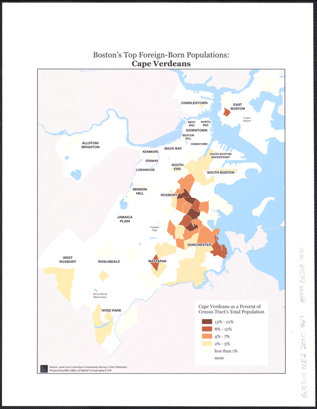
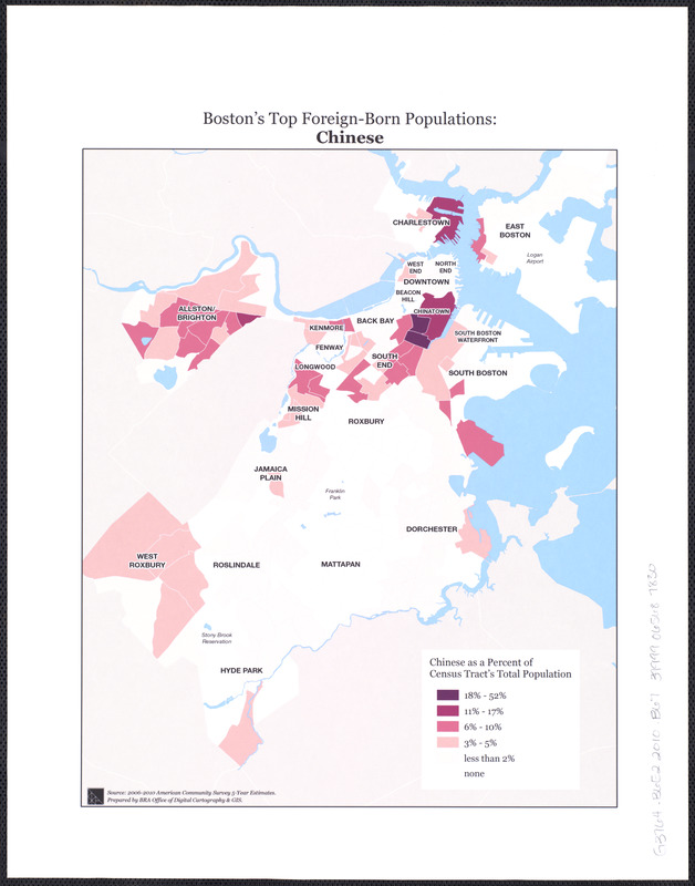
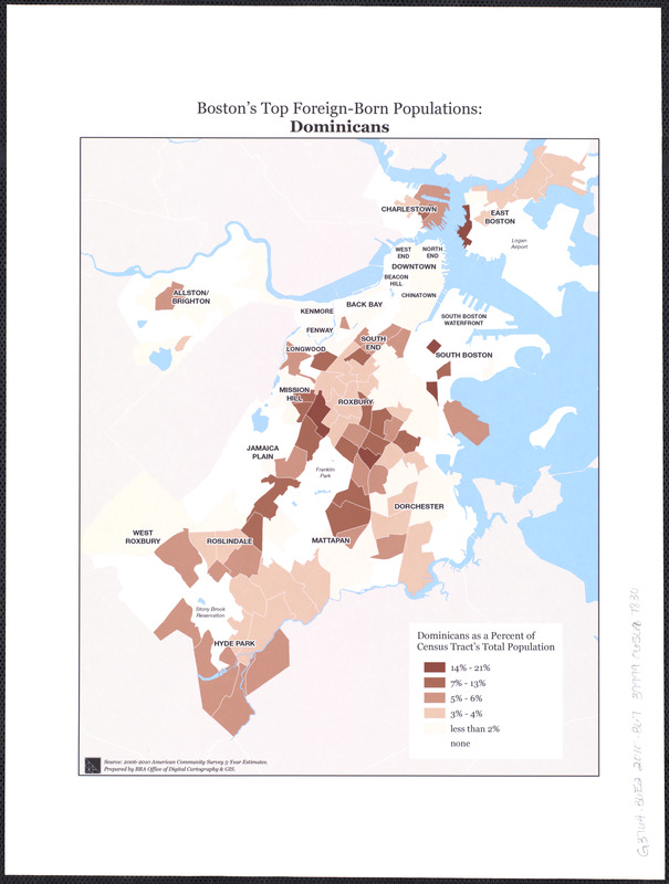
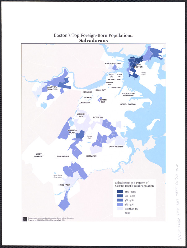
[Percentage of Foreign-Born Bostonians by Census Tract]
Boston, [2010]
Courtesy Boston Redevelopment Authority
The Boston Redevelopment Authority, utilizing the latest GIS (Geographic Information Systems) technologies and data collected during the 2010 census, created a variety of thematic maps locating and analyzing Boston’s population and its demographic characteristics. One series shows the location of foreign-born immigrants according to their country of origin. According to the U.S Census Bureau, the patterns of immigration to Boston during the first decades of the 21st century are much different than the first decades of the 20th century. Currently the majority of immigrant groups come from Latin America (48.4%) and Asia (25.5%), while those coming 100 years ago came mainly from Europe (Ireland, Italy, and Russia).
La Autoridad de Reurbanización de Boston utiliza las últimas tecnologías SIG (Sistemas de Información Geográfica) y la información recopilada durante el censo de 2010 y creó una variedad de mapas temáticos de localización y análisis de la población de Boston y sus características demográficas. Una serie muestra la ubicación de los inmigrantes de origen extranjero según su país de origen. Según la Oficina de Censos de los E.E.U.U., los patrones de la inmigración a Boston durante las primeras décadas del siglo 21 son muy diferentes a los de las primeras décadas del siglo 20. En la actualidad la mayoría de los grupos de inmigrantes provienen de América Latina (48,4%) y Asia (25,5%), mientras que los que vinieron hace 100 años vinieron principalmente de Europa (Irlanda, Italia, y Rusia).
Boston Redevelopment Authority a, nan itilize dènye GIS nan (Geographic Information Systems) teknoloji ak done yo te kolekte pandan resansman 2010 la, ki te kreye yon varyete de kat tematik nan lokalize epi analize popilasyon Boston yo, ak karakteristik demografik li yo. Yon seri montre kote imigran ki fèt aletranje yo rete daprè peyi orijin pa yo. Daprè Biwo Resansman Etazini, modèl nan imigrasyon yo nan Boston pandan premye deseni yo nan 21yèm syèk la yo pi diferan pase premye deseni yo nan 20yèm syèk la. Aktyèlman majorite gwoup imigran soti nan Amerik Latin (48.4%) ak Azi (25.5%), pandan sa yo ki te vini 100 lane de sa te vini soti prensipalman nan Ewòp (Iland, Itali, ak Larisi).
波士顿重建局, 使用最新的GIS(地理信息系统)技术, 和2010年人口普查中收集的数据, 找出和分析波士顿的人口和人口特徵制作出各种专题地图. 其中一个系列的专题地图根据原籍国显示外国出生的移民的位置. 根据美国人口普查局, 21世纪第一个十年的波士顿移民大大不同于20世纪第一个十年的移民. 现在的移民群体主要来自拉丁美洲 (48.4%)和亚洲(25.5%), 而100年前的移民主要来自欧洲(爱尔兰, 意大利, 和俄国).
Boston Redevelopment Authority, Research Division, Office of Digital Cartography and GIS.
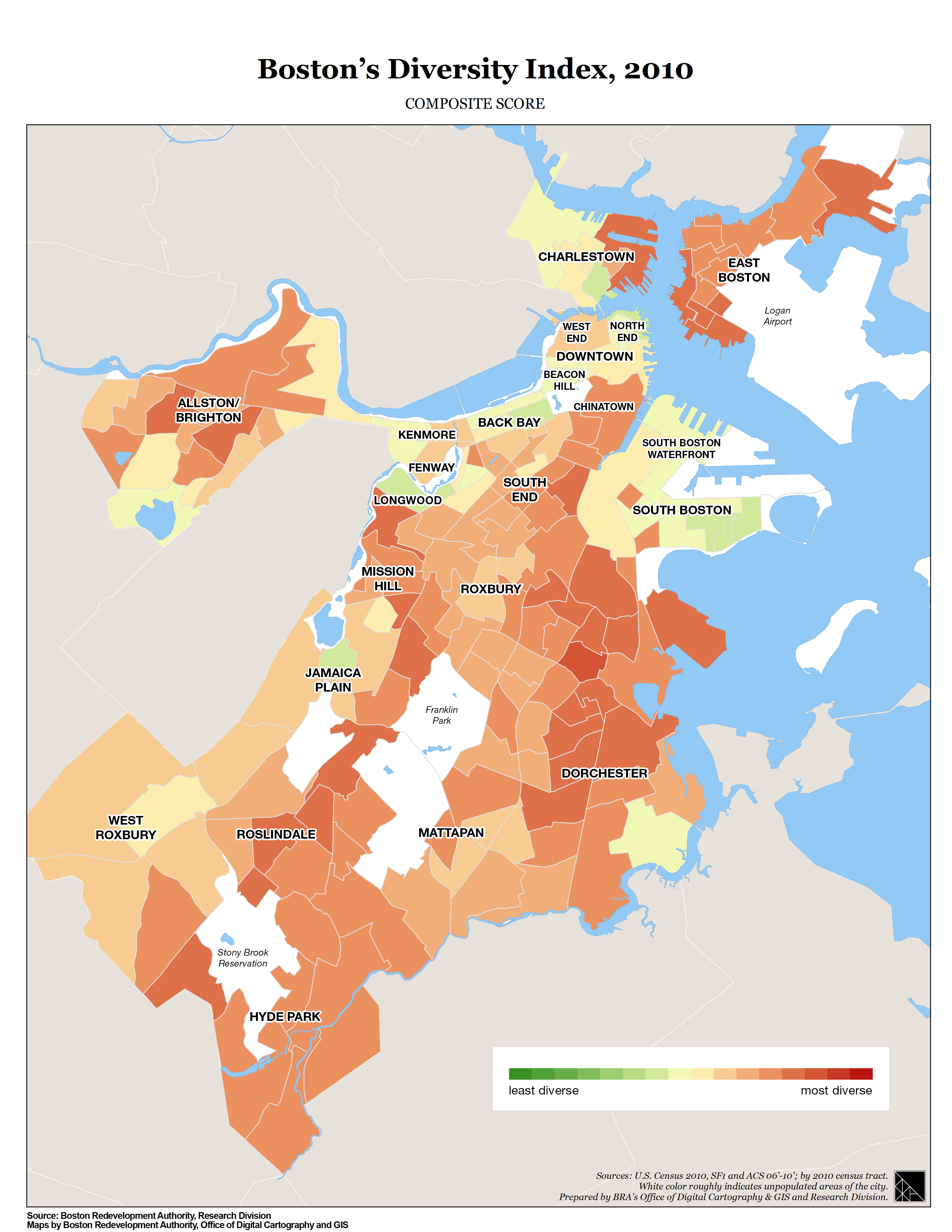
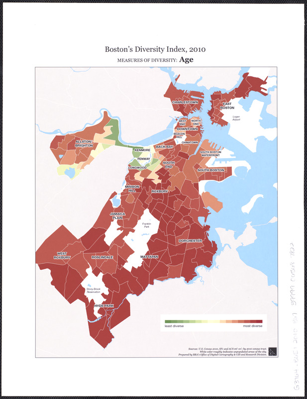
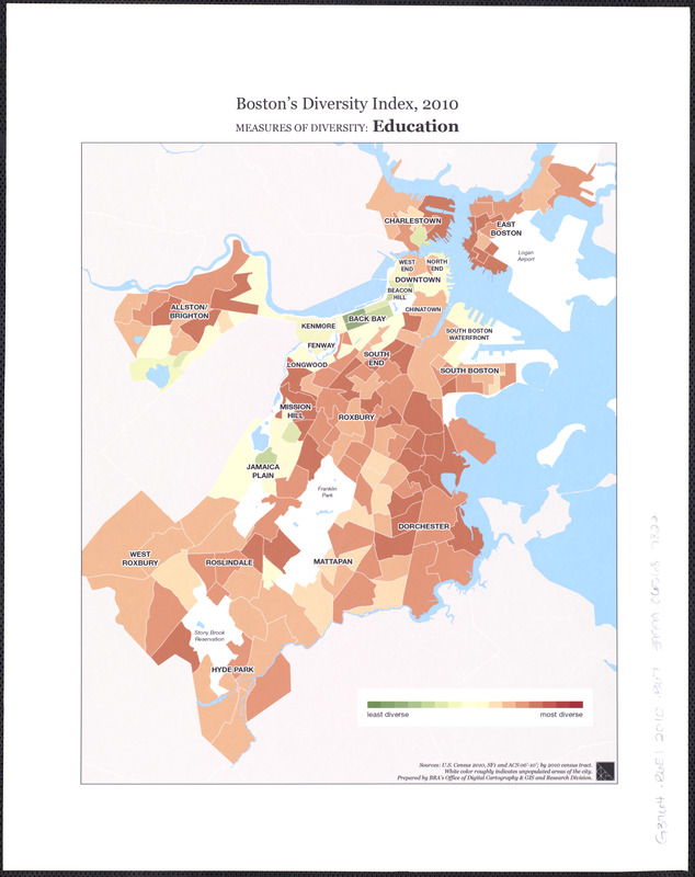
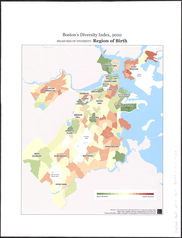
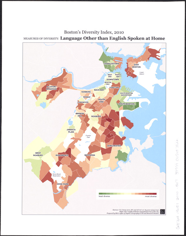
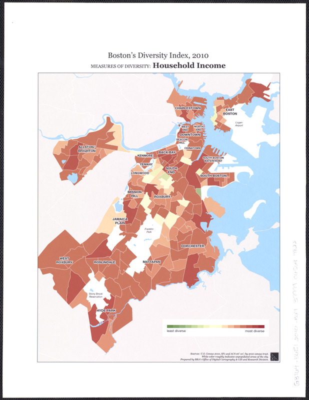
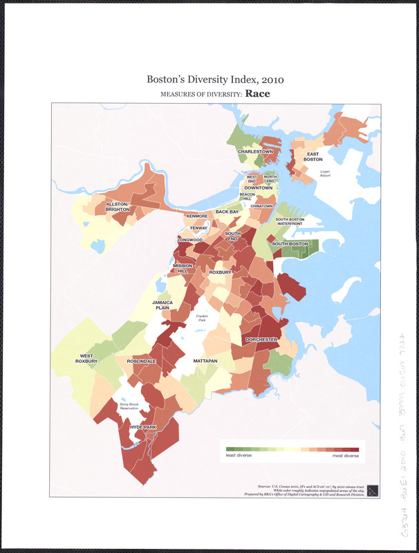
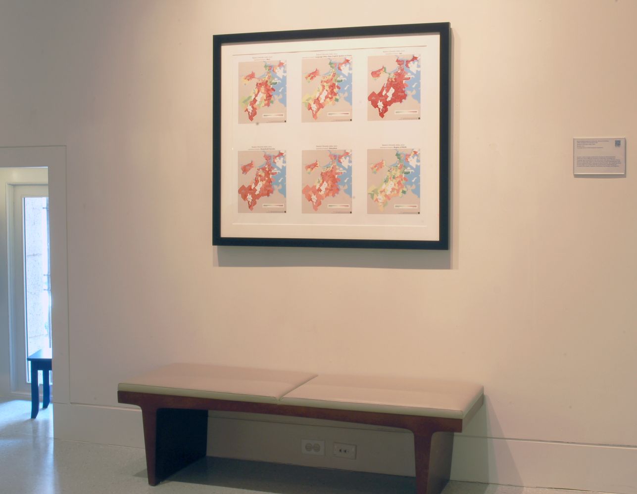
Boston’s Diversity Index, 2010
Boston, 2010
Courtesy Boston Redevelopment Authority
Another series of maps produced by the Boston Redevelopment Authority shows different measures of diversity, including race, language, age, household income, education, and region of birth. Census tracts on each map range in color from deep orange (indicating the most diverse neighborhoods) to deep green (least diverse). By comparing these various maps, it is evident that the most diverse census tracts are located in Dorchester, Roxbury, Roslindale, East Boston, and Brighton.
Otra serie de mapas producidos por la Autoridad de Reurbanización de Boston muestran diferentes medidas de diversidad, como raza, idioma, edad, ingreso familiar, educación y la región de nacimiento. Las zonas del censo en cada mapa varían en color desde el naranja intenso (que indica las vecindades más diversas) al verde oscuro (menos diversa). Comparando los diferentes mapas es evidente que las zonas más diversas según el censo se encuentran en Dorchester, Roxbury, Roslindale, East Boston y Brighton.
Yon lòt seri de kat jeyografik ki te pwodui pa Boston Redevelopment Authority a montre diferan mezi divèsite, ki gen ladan ras, lang, laj, revni kay, edikasyon, ak rejyon nesans. Sektè resansman sou chak kat jeyografik etann yo nan koulè ki soti nan jòn abriko fonse (ki endike katye ki pi divèsifye yo) rive nan gwo koulè vèt (ki mwen divès). Lè nou konpare kat jeyografik varye sa yo, li evidan ke sektè resansman pi divèsifye yo sitiye nan Dorchester, Roxbury, Roslindale, East Boston, ak Brighton.
由波士顿重建局制作的另一系列地图显示了人口特徵的多元性, 包括种族, 语言, 年龄, 家庭收入, 教育, 出生地区. 每个地图用颜色深浅显示人口普查区, 从深橙色(表示最多元化的城区) 到深绿色(最少多元化的城区). 通过比较这些不同人口普查区地图, 可见最多元化的城区位于多切斯特, 罗克斯伯里, 罗斯林代尔, 东波士顿, 和布莱顿.
Massachusetts Division of Banks.
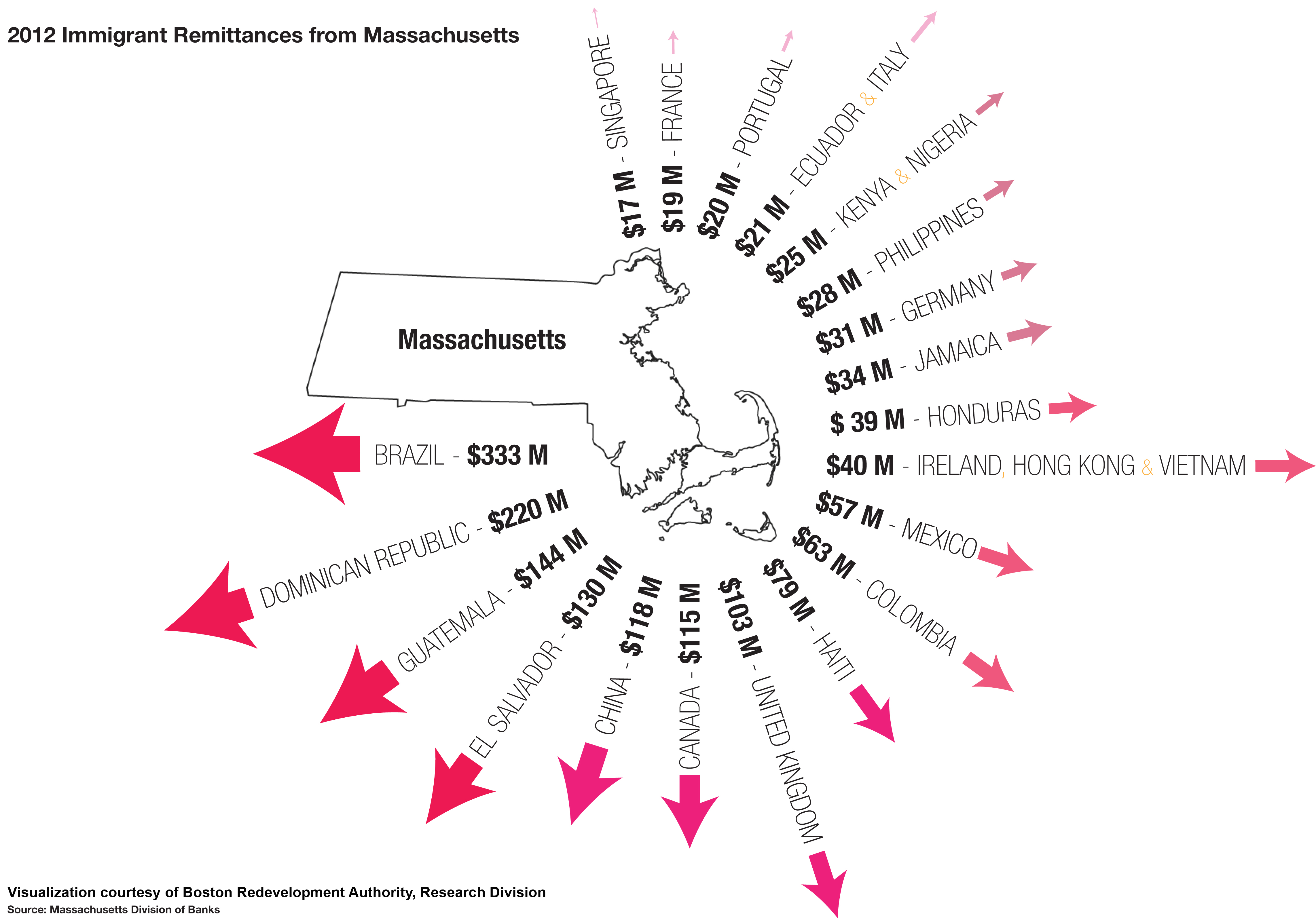
2012 Immigrant Remittances from Massachusetts
Boston, 2013
Courtesy Boston Redevelopment Authority
Foreign-born communities in Boston often maintain strong ties across national borders, a concept known as transnationalism. This graphic shows the top 20 countries receiving remittance transfers from Massachusetts residents. While many immigrants continue to participate in the economic, political and cultural lives of their home countries, they are also integral to Boston’s economy. Consider that:
- Immigrants accounted for approximately 68.4% of Massachusetts’ labor force growth from 2000 to 2010
- 44% of Boston immigrants are naturalized citizens
- Boston immigrants own more than 8,800 small businesses
- Boston immigrants pay more than $293 million in state and federal taxes
Las comunidades de origen extranjero en Boston a menudo mantienen vínculos fuertes más allá de las fronteras nacionales, un concepto conocido como transnacionalismo. Este gráfico muestra los 20 principales países que reciben transferencias de remesas de los residentes de Massachusetts. Aunque muchos inmigrantes siguen participando de la vida económica, política y cultural de sus países de origen, son también parte integral de la economía de Boston. Considere lo siguiente:
- Los inmigrantes representaron aproximadamente el 68,4% del crecimiento de la fuerza laboral de Massachusetts del 2000 al 2010
- El 44% de los inmigrantes de Boston son ciudadanos por naturalización
- Los inmigrantes de Boston son propietarios de más de 8.800 pequeñas empresas
- Los inmigrantes de Boston pagan más de $293 millones en impuestos estatales y federales
Kominote Etranje nan Boston souvan kenbe lyen fò atravè tout fwontyè nasyonal yo, yon konsèp ke yo konnen kòm transnasyonalis. Grafik sa a montre 20 peyi nan tèt yo k’ap resevwa remiz transfè soti nan men rezidan Massachusetts. Pandan ke anpil moun imigran kontinye patisipe nan lavi ekonomik, politik ak kiltirèl nan peyi lakay, yo an menm tan entegral nan ekonomi Boston an. konsidere sa:
- Imigran konte pou apeprè 68,4% nan kwasans fòs travay Massachusetts sòti nan lane 2000 rive nan 2010
- 44% nan imigran Boston yo se sitwayen natiralize
- Imigran Boston posede plis pase 8.800 ti biznis
- Imigran Boston yo peye plis pase $293 milyon nan taks leta ak federal
在波士顿外国出生的群体经常跨越国界与母国保持紧密的关系, 这个概念称为跨国主义.此图显示收到来自马萨诸塞州居民汇款的前20个国家. 虽然许多移民继续参加其母国的经济, 政治和文化生活, 但是他们也是波士顿经济不可缺少的一部分. 请看数据:
- 从 2000年到2010年移民大约占了马萨诸塞州劳动力增长的68.4%
- 44% 的波士顿移民是归化公民
- 波士顿移民拥有超过8,800个小型生意
- 波士顿移民支付的州和联邦税超过2亿9千3百万美元
2. 1910 Boston
Between the Civil War and World War I (1860s-1920s), Boston’s population nearly tripled due to Eastern European and Italian immigration, as well as southern African Americans and West Indians. The city experienced a rapid transformation, becoming more urban and industrial and much more diverse. By the time of the 1910 census, Boston had over 670,000 residents with a foreign-born population of over 240,000 or 36% of the residents. Boston was ranked fifth in the size of its population in the United States. It ranks 21st today. Boston’s neighborhood boundaries and streets looked mostly as we know them today, with the exception of Hyde Park, annexed in 1912.
Entre la Guerra Civil y la Primera Guerra Mundial (1860s-1920s), la población de Boston casi se triplicó debido a la inmigración de la Europa del Este y la italiana, también por los Afroamericanos del sur y las Indias Occidentales. La ciudad experimentó una rápida transformación cada vez más urbana e industrial y mucho más diversa. Para el censo de 1910, Boston tenía más de 670.000 residentes con una población de origen extranjero de más de 240.000 o el 36% de los residentes. Boston fue clasificada quinta en el tamaño de su población en los Estados Unidos. En la actualidad ocupa el puesto 21. Los límites de las ciudades y calles de Boston lucían como los conocemos hoy en día, con la excepción de Hyde Park, anexado en 1912.
Ant Lagè Sivil la ak Premyè Gè Mondyal (ane 1860-1920 yo), popilasyon Boston te prèske triple akòz Ewòp de Lès ak imigrasyon Italyen, men tou, sid Ameriken Afriken ak Endyen Lwès yo. Vil la te eksperimante yon transfòmasyon rapid, nan vini pi plis ibèn ak endistriyèl epi plis ankò divès. Depi lè a nan resansman 1910 yo, Boston te gen plis pase 670.000 rezidan ak yon popilasyon ki fèt aletranje nan plis pase 240,000 oswa 36% nan rezidan yo. Boston te klase senkyèm nan gwosè popilasyon li yo nan peyi Etazini. Li klase 21yèm jodi a. Limit katye Boston yo ak lari yo te sanble pou laplipa jan nou konnen yo jodi a, aleksepsyon Hyde Park, ki te anekse nan ane 1912.
在国内战争和第一次世界大战之间 (1860s-1920s), 不但由于东欧和意大利移民的增加, 而且南部非裔美国人和西印度人也在增加, 波士顿的人口将近翻了三倍. 城市经历着快速改变, 成为更加城市化和工业化以及更加多样化的城市. 在1910年的人口调查中, 波士顿的居民已经超过670,000, 其中外国出生人口超过240,000, 占总居民人数36% . 那时波士顿的人口数量在美国排行第5. 现在波士顿的人口数量在美国排行第21. 除了在1912年并入的海德公园地区, 波士顿城区的边界和街道与我们今天所看到的大致一样.
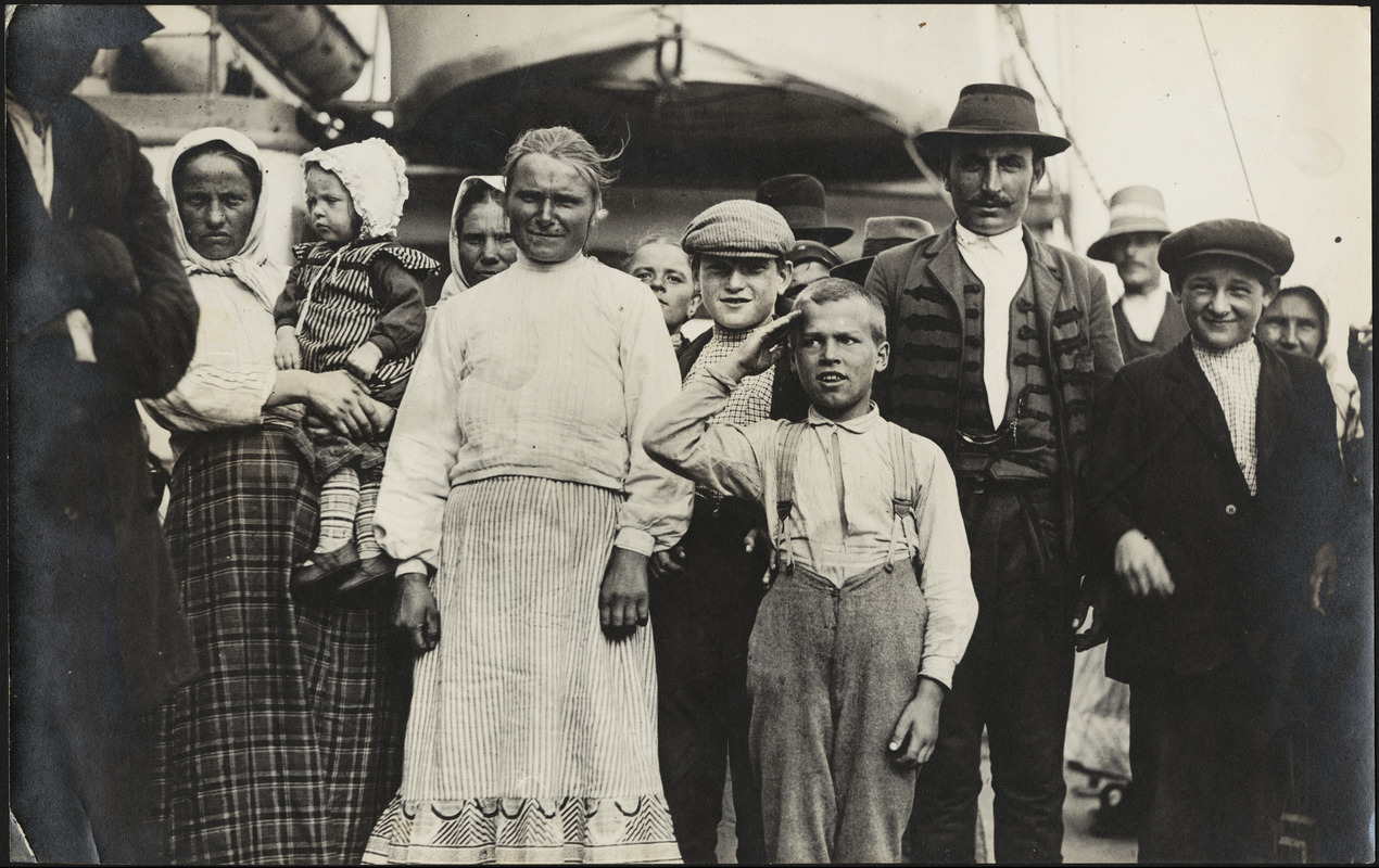
Edmunds E. Bond (1871-1961).
[Image of Immigrants Arriving in Boston]
[Boston, ca. 1895]
Courtesy of the Trustees of the Boston Public Library, Print Department
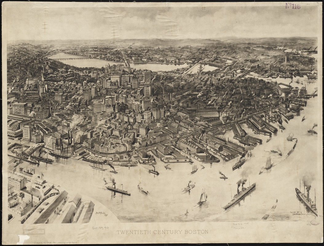
A.F. Poole.
Twentieth Century Boston
Boston, 1905
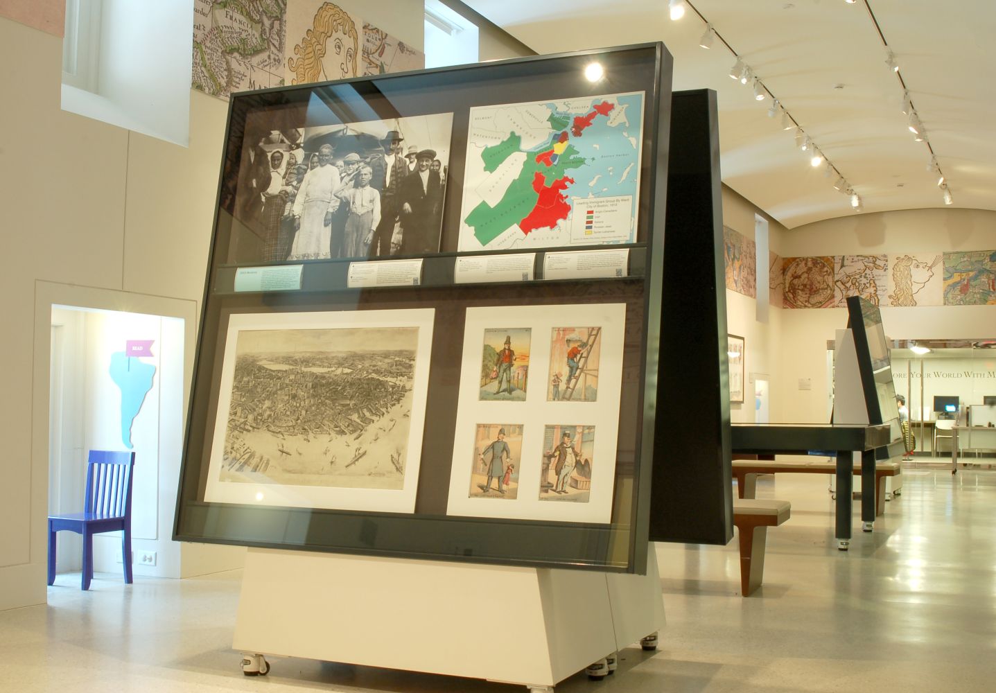
Boston was the second busiest port of entry for new immigrants in the early 20th century. Between 1900-1910, over 530,000 immigrants arrived at the docks in Boston, as illustrated in the 1895 photograph (above) and the 1905 bird’s-eye view (below) featuring Boston’s harbor. The proportion of foreign-born residents in Boston (and in the United States as a whole) peaked in 1910, before immigration restrictions and quotas were enacted in the 1920s, limiting new immigrants based on the proportion of people of that nationality at that time and specifically further restricting immigration from China or Japan. In 1965 the United States significantly changed its immigration policies, attracting new groups of people and dramatically increasing the foreign-born population.
Boston fue el segundo puerto de entrada más activo para los nuevos inmigrantes en el comienzo del siglo 20. Entre 1900-1910 más de 530.000 inmigrantes llegaron a los muelles de Boston, como se ilustra en la fotografía de 1895 (arriba) y en la vista de ojo de pájaro de 1905 (abajo) del puerto de Boston. La proporción de residentes de origen extranjero en Boston (y en los Estados Unidos en conjunto) alcanzó su punto máximo en 1910, antes de que se promulgaran las restricciones y cuotas de inmigración en 1920, limitando a los nuevos inmigrantes en función de la proporción de personas de esa nacionalidad en ese momento y restringir de manera específica la inmigración procedente de China o Japón. En 1965 Estados Unidos cambió de manera significativa sus políticas en materia de inmigración, atrayendo a nuevos grupos de personas y aumentando drásticamente la población de origen extranjero.
Boston te dezyèm pò dantre ki pi okipe pou nouvo imigran byen bonè nan 20yèm syèk la. Ant ane 1900-1910, plis pase 530,000 imigran te rive nan waf yo nan Boston, jan yo montre nan foto 1895 la (anlè a) ak vi ayeryèn 1905 la (anba a) prezante pò Boston an. Pwopòsyon rezidan ki fèt aletranje nan Boston (ak nan Etazini an antye) te monte an 1910, anvan entèdiksyon imigrasyon ak kota yo te mete an vigè nan ane 1920 yo, kote yo te limite nouvo imigran baze sou pwopòsyon moun ki gen nasyonalite sa a nan tan sa a espesyalman ki mete entèdiksyon sou imigrasyon ki soti nan Lachin oswa Japon. An 1965 Etazini te chanje politik imigrasyon li yo siyifikativman, nan atire nouvo gwoup moun epi ogmante popilasyon ki fèt aletranje a dramatikman.
在20世纪初期, 波士顿是第二繁忙的新移民入境港口. 1900-1910年间, 在波士顿海港1895年的照片(上图)和1905年的鸟瞰图(下图)显示,超过530,000移民抵达波士顿码头. 在1910年, 波士顿(和全美国)的外国出生居民人数达到顶峰, 在20世纪20年代移民限制和配额制定之前,对新移民的限制是根据当时国籍人数的比例决定, 并且特别限制来自中国或日本的移民. 1965年, 美国的移民政策有了重大的改变, 吸引了新的移民群体, 显著地增加了外国出生的人口.
Blake Gumprecht.
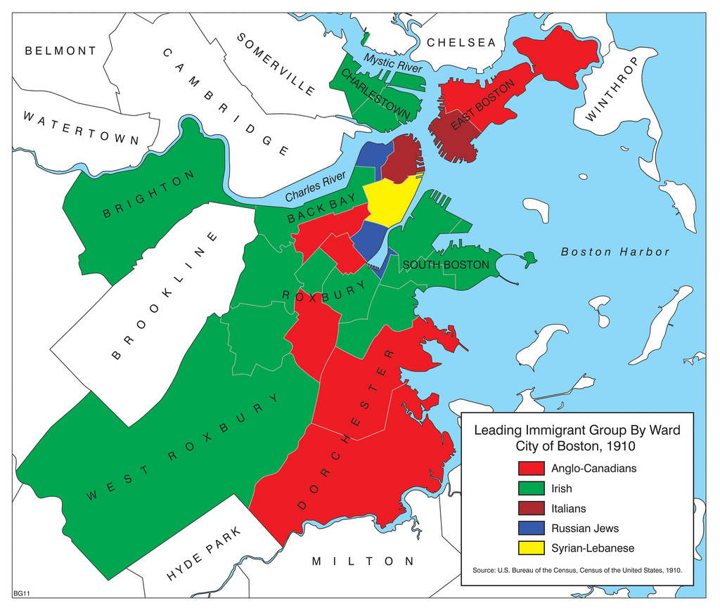
“Leading Immigrant Group by Ward, City of Boston, 1910”, from The Peopling of New England
2011
Courtesy Blake Gumprecht
This map, created for The Peopling of New England book project by geographer Blake Gumprecht at the University of New Hampshire, when compared with the thematic maps along the wall, shows the dramatic change in 100 years of major immigrant groups in Boston. While the top two most common ancestries for Bostonians today remain Irish and Italian, the top two current immigrant groups hail from the Dominican Republic and China.
Este mapa, creado en la universidad de New Hampshire por el geógrafo Blake Gumprecht para el proyecto del libro El Poblamiento de Nueva Inglaterra, cuando es comparado con los mapas temáticos a lo largo de la pared, muestra el cambio dramático en 100 años de los principales grupos de inmigrantes en Boston. Aunque las dos primeras ascendencias más comunes para los bostonianos siguen siendo hoy las irlandesas e italianas, los dos principales grupos de inmigrantes actuales provienen de la República Dominicana y de la China.
Kat sa a, te kreye pou pwojè liv The Peopling of New England pa jeyograf Blake Gumprecht nan University of New Hampshire, lè yo konpare ak kat jeyografik tematik sou miray la, li montre chanjman dramatik nan 100 lane majorite gwoup imigran nan Boston yo. Pandan ke tèt de zansèt ki pi komen pou Bostonyen jodi a rete Ilandè ak Italyen, de tèt gwoup imigran aktyèl yo soti nan Repiblik Dominikèn ak Lachin.
这张地图, 是新罕布什尔大学地理学家布雷克•普雷希特为名为居住于新英格兰的书项目制作的, 将这张地图与沿着墙边的专题地图比较, 便能看出波士顿在100年内的主要移民群体发生的巨大变化. 今天波士顿最常见的两组移民后裔群体仍然是爱尔兰人和意大利人, 但是排名前两位的当前移民群体分别来自于多明尼加共和国和中国.
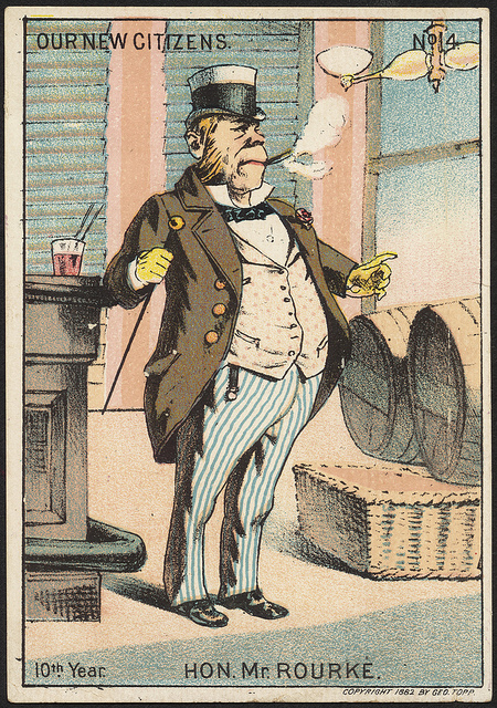
Geo. Topp.
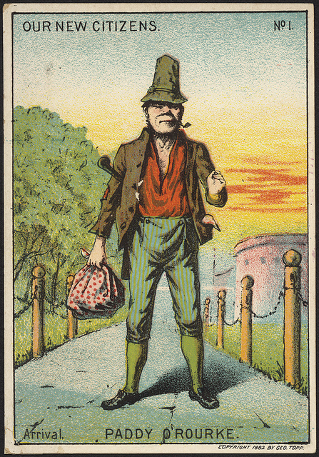
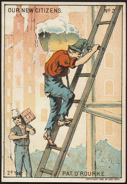
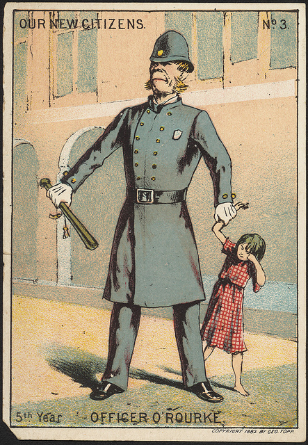
Our New Citizens, Nos. 1-4
c1882
Courtesy of the Trustees of the Boston Public Library, Print Department
As depicted in this series of advertising trade cards, the expected path for new immigrants from the 1850s to the 1910s was to climb the occupational and social ladder in America. As the Irish middle class was expanding, many immigrants moved from jobs as laborers to civil service jobs. While celebrating “Our New Citizens,” the figure of Patrick O’Rourke is also drawn as a caricature and labeled “Paddy,” an ethnic slur aimed at Irish men.
Como se muestra en esta serie de tarjetas comerciales de publicidad, la tendencia prevista para los nuevos inmigrantes de la década de los 1850 hasta la de 1910 fue subir la escalera laboral y social en América. A medida que la clase media irlandesa se expandía, muchos inmigrantes pasaron de trabajos como obreros a puestos de trabajo de la administración pública. Aunque celebramos a “Nuestros Nuevos Ciudadanos”, la figura de Patrick O’Rourke también se dibuja como una caricatura que es etiquetada como “Paddy”, un insulto étnico dirigido a los hombres irlandeses.
Jan li montre nan seri sa a nan kat komès piblisite yo, chemen ki espere pou nouvo imigran ki sòti nan ane 1850 rive 1910 yo te dwe monte nechèl okipasyonèl ak sosyal nan America. Pandan klas mitan Ilandè a t’ap etann li, plizyè imigran te deplase soti nan travay kòm travayè nan travay sèvis sivil. Pandan y’ap selebre “Our New Citizens,” figi Patrick O’Rourke la te trase tou kòm yon karikati epi te make “Paddy,” yon ensilt etnik ki vize a moun ki Ilandè.
如这一系列的广告贸易卡所描述, 从19世纪50年代到20世纪10年代的新移民的期望生涯路径是在美国攀登职业和社会地位. 随着爱尔兰人中产阶级不断扩大, 许多移民从劳动者工作晋升到公务员职位.在庆祝“我们的新市民” 画中的人物, 帕特里克•奥罗克被画成漫画,并标有“Paddy” , 这是一种对爱尔兰民族的污辱.
3. East Boston
East Boston is built on several islands that were gradually filled in over 150 years. By 1900, East Boston was home to one of the largest Jewish communities in Boston. However by 1915, Italian immigrants had become the major ethnic group in the neighborhood. Today it is one of Boston’s most diverse neighborhoods, including foreign-born communities predominately from Colombia and El Salvador.
East Boston está construida sobre varias islas que se llenaron gradualmente en más de 150 años. En 1900, East Boston fue el hogar de una de las comunidades judías más grandes de Boston. Sin embargo en 1915, los inmigrantes italianos se habían convertido en el grupo étnico más importante en la vecindad. Hoy en día es una de las más diversas vecindades de Boston que incluye comunidades de origen extranjero predominantemente de Colombia y de El Salvador.
East Boston bati sou plizyè zile ki te piti piti bouche nan plis pase 150 ane. Apati 1900, East Boston te vin kay pou youn nan pi gwo kominote jwif nan Boston. Sepandan apati 1915, imigran Italyen yo te vin tounen majorite gwoup etnik la nan katye a. Jodi a li se youn nan katye ki pi divès nan Boston, ki gen ladan kominote ki fèt aletranje ak predominans soti nan Lakolonbi ak El Salvadò.
在过去的150年里, 东波士顿由几个岛屿逐渐填补而成. 直到1900年, 东波士顿是波士顿里最大犹太人社区之一. 但是到1915年, 意大利移民已变成这一城区的主要族裔群体. 今天, 东波士顿已是波士顿里最多元化的城区之一, 包括外国出生的群体, 主要是来自哥伦比亚和萨尔瓦多.
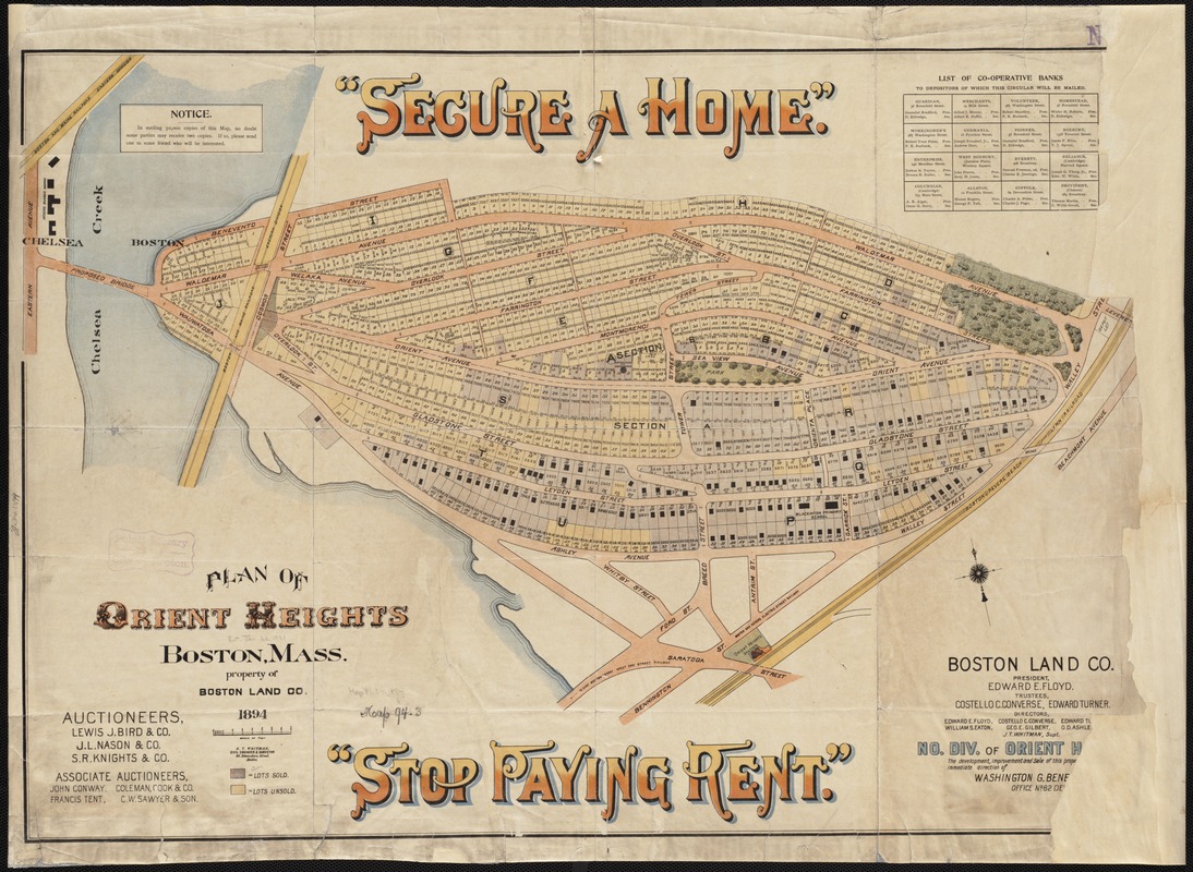
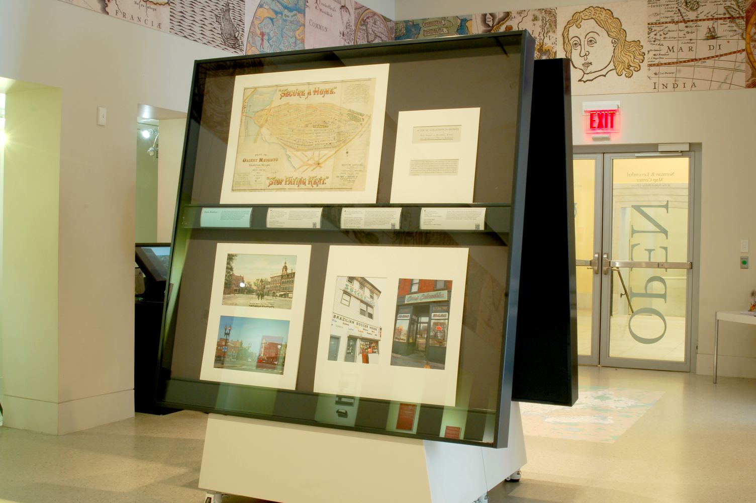
Boston Land Company.
Plan of Orient Heights, Boston, Mass.
Boston, 1894
With Boston’s rising population and increased demand for housing, the Boston Land Company began to develop former marshland in East Boston in the 1880s, including Hog Island (also called Breed’s Island) which became Orient Heights. A promotional map from the Boston Land Company and brochure from the East Boston Company, formed to oversee the residential and commercial development of the neighborhood, highlight the opportunity to own a single family home, away from the more densely settled neighborhoods of the North End and West End.
Con el aumento de la población de Boston y la demanda creciente de vivienda, Boston Land Company comenzó a urbanizar lo que fue la región pantanosa en East Boston en la década de 1880, como Hog Island (también llamada Breed´s Island) que se convirtió en Orient Heights. Un mapa promocional de Boston Land Company y el folleto de East Boston Company que fueron modelados para supervisar la urbanización residencial y comercial de la vecindad, destacan la oportunidad de poseer una vivienda unifamiliar lejos de las vecindades más densamente pobladas del North End y del West End.
Ak popilasyon Boston k’ap monte epi demann pou lojman ki ogmante, Boston Land Company te kòmanse devlope ansyen marshland nan East Boston nan lane 1880 yo, ki gen ladan Hog Island (yo rele tou Breed's Island) ki te vin Orient Heights. Yon kat pwomosyonèl nan Boston Land Company ak brochi ki soti nan East Boston Company, te fòme pou reskonsab devlopman kontwòl rezidansyèl ak komèsyal katye a, mete aksan sou opòtinite pou posede yon kay fanmi endividyèl, pi lwen katye yo ki pi plis abite nan North End nan ak West End.
随着波士顿人口增长和对住房需求的增加, 波士顿土地公司在19世纪80年代, 开始发展东波士顿的前沼泽地, 包括猪岛(又称犬岛), 成为东方高地. 波士顿土地公司印发宣传地图, 东波士顿公司印发宣传册子, 共同监督该城区住宅及商业发展, 突出宣传拥有远离较稠密的北区和西区的单家庭住宅机会.
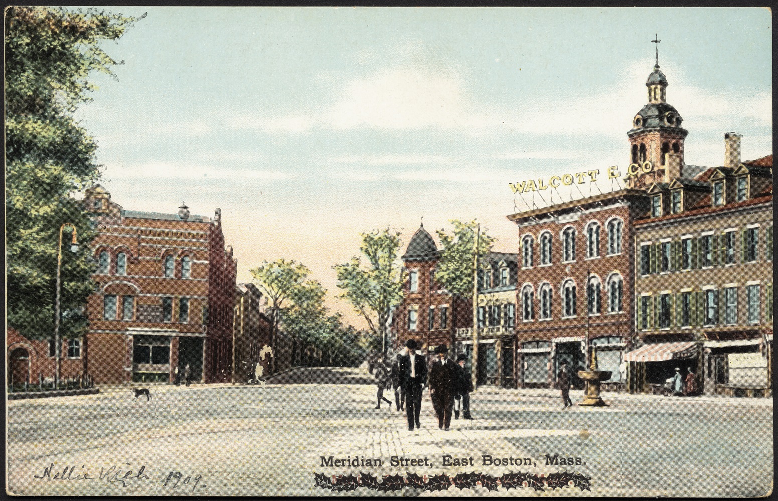
Reichner Brothers.
Meridian Street, East Boston, Mass.
Boston, ca. 1905
Courtesy of the Trustees of the Boston Public Library, Print Department
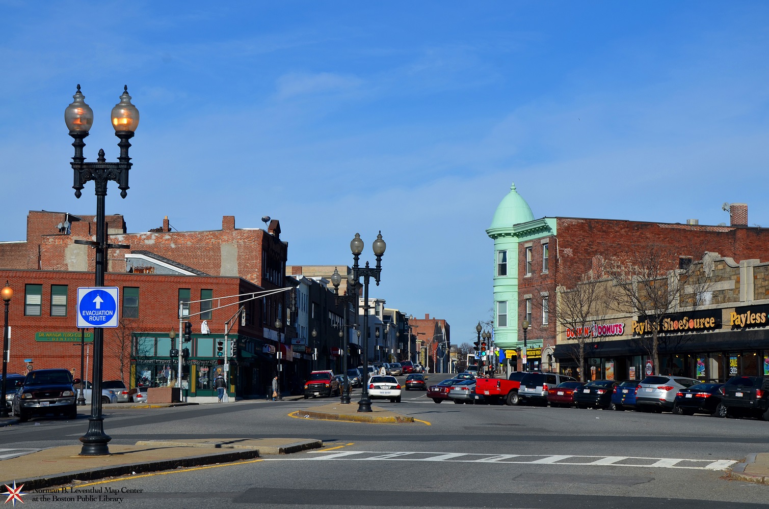
Lisa Cordner.
Meridian Street, East Boston, MA
Boston, 2014
Courtesy Lisa Cordner Images
Central Square in East Boston has long been a hub of economic activity at the junction of Meridian, Porter, Bennington, Saratoga, Border, and Liverpool streets. This 1905 postcard shows a lively pedestrian area dominated by Walcott and Company, a dry goods store. Still today the location is occupied by retail and other commercial stores, as seen in the accompanying modern photo.
Central Square en East Boston ha sido durante mucho tiempo un centro de actividad económica en el cruce de las calles Meridian, Porter, Bennington, Saratoga, Border y Liverpool. Esta postal de 1905 muestra una animada zona peatonal dominada por Walcott and Company, una tienda de productos secos. Aún hoy día el lugar está ocupado por tiendas comerciales minoristas y otras, como se ve en la foto moderna adjunta.
Central Square nan East Boston ki depi lontan te yon sant nan aktivite ekonomik nan jonksyon Meridian, Porter, Bennington, Saratoga, Border, ak Liverpool streets. Kat postal 1905 sa a montre yon zòn pyeton vivan domine pa Walcott and Company, yon magazen machandiz sèch. Jodi a toujou zòn sa okipe pa vant an detay ak lòt magazen komèsyal, jan yo wè nan foto modèn ki akonpaye l’ yo.
东波士顿的中环广场一直是经济活动的枢纽经络, 是玛丽典, 波特, 本宁顿, 萨拉托加, 波得, 和利物浦街的交界处. 这张1905年明信片显示了以沃尔科特公司, 一个干货店, 为主导的热闹的步行区. 从伴随的现代照片中可见, 直到今天, 中环广场都是由零售及其他商业店铺占用.
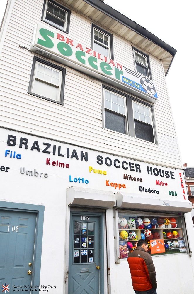
Lisa Cordner.
Brazilian Soccer House
Boston, 2014
Courtesy Lisa Cordner Images
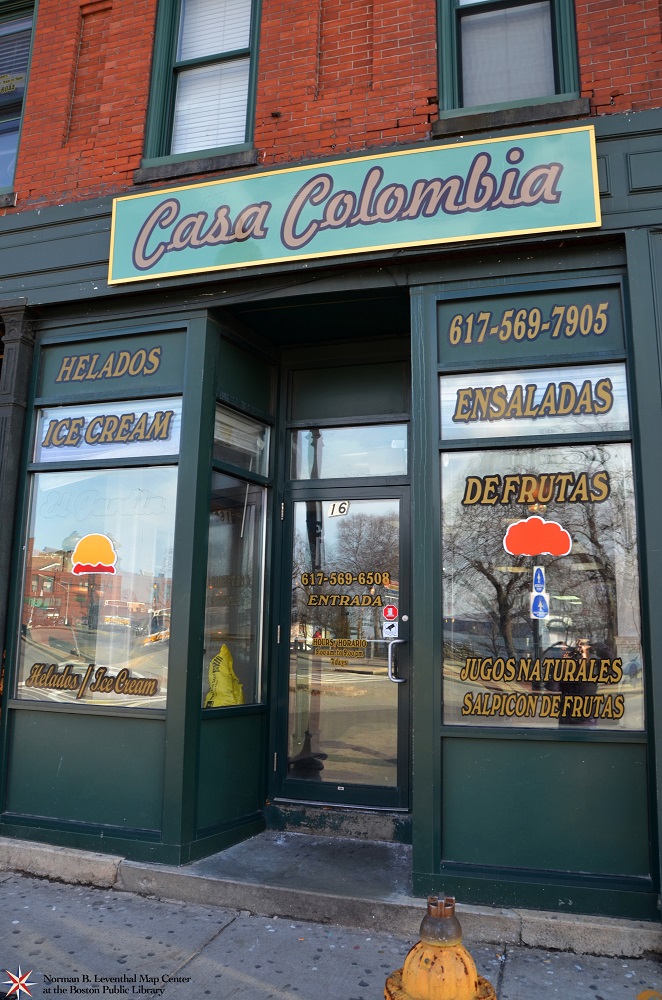
Lisa Cordner.
Casa Colombia
Boston, 2014
Courtesy Lisa Cordner Images
Modern views of Central Square showing its restaurants and businesses illustrate the dynamic mix of cultures and the fact that East Boston’s population is almost 50% foreign-born, the highest percentage of all Boston’s neighborhoods. The two businesses pictured here are current examples of local businesses, both associating a country in their names.
Las vistas modernas de Central Square que muestran sus restaurantes y negocios ilustran la mezcla dinámica de culturas y el hecho de que la población de East Boston es casi el 50% de origen extranjero, el porcentaje más alto de todas las comunidades de Boston. Los dos negocios representados aquí son ejemplos actuales de los negocios locales, ambos asocian un país en sus nombres.
Imaj modèn Central Square ki montre restoran ak biznis li yo ilistre melanj dinamik kilti ak lefèt ke popilasyon East Boston an se prèske 50% moun ki fèt a letranje, pousantaj ki pi wo a nan tout katye Boston yo. De biznis ki montre la yo se egzanp aktyèl nan biznis lokal yo, tou lede asosye yon peyi nan non yo.
现代照片里的中环广场中的餐馆和商业显示了不断变化的文化组合. 事实上, 在东波士顿的外国出生人口已接近50%, 是所有波士顿城区中比例最高的. 这里的两张商业图片是现时地方商业的例子, 这两家商业的名字都与一个国家有关联.
4. Dorchester
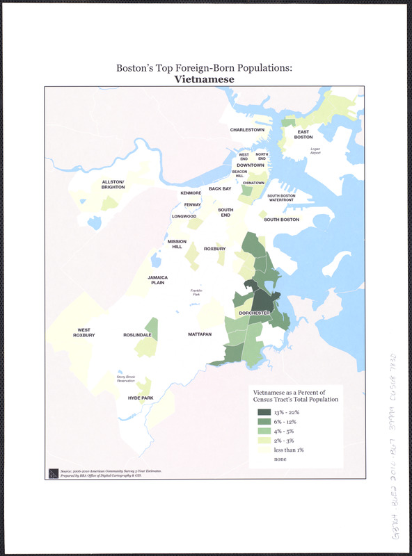
Dorchester is Boston’s largest, most populous and most diverse neighborhood. Business districts and communities make up the landscape of Dorchester, from Fields Corner and Uphams Corner to Savin Hill and Codman Square. With a population of over 114,000, Dorchester has the highest percentage of children, with 30% of the neighborhood under 18 years of age. Dorchester is home to many newer immigrant communities, including those from Vietnam and Cape Verde.
Dorchester es la comunidad más grande de Boston, más poblada y más diversa. Los distritos comerciales y las comunidades conforman el paisaje de Dorchester desde Fields Corner y Uphams Corner hasta Savin Hill y Codman Square. Con una población de más de 114.000, Dorchester tiene el porcentaje más alto de niños con un 30% de la comunidad con menos de 18 años de edad. Dorchester es el hogar de muchas comunidades de inmigrantes más recientes, como las procedentes de Vietnam y de Cabo Verde.
Dorchester se pi gwo, katye nan Boston ki pli peple epi pli divèsifye. Distri biznis ak kominote konpoze peyizaj Dorchester, ki soti nan Fields Corner ak Uphams Corner rive nan Savin Hill ak Codman Square. Avèk yon popilasyon plis pase 114.000, Dorchester gen pousantaj timoun ki pli wo a, avèk 30% nan katye a ki anba laj 18 lane. Dorchester se kay plizyè nouvo kominote imigran, ki gen ladan moun ki soti nan Vyetnam ak Kap Vèd.
多切斯特是波士顿最大, 人口最多和最多元化的城区. 从场角和阿巴汗思角, 到萨山和科德曼广场, 其中的商业区和社区绘出了多切斯特的景观. 多切斯特的人口超过 114,000, 多切斯特未满18岁小孩人数比例最高, 占城区人口30%. 多切斯特是一个有许多新移民的社区, 移民包括来自越南和佛得角.
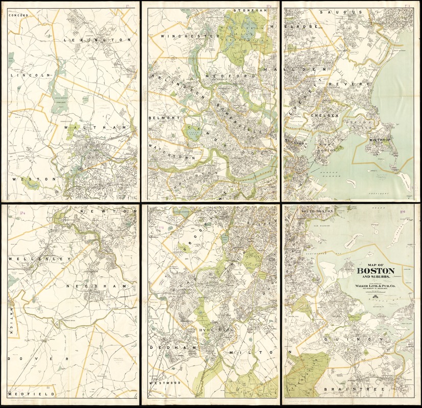
Walker Lith. and Pub. Co.
Map of Boston and Suburbs
Boston, 1913
Established as a town in 1630, Dorchester remained a rural community until the 1870s and 1880s. In the early 1900s the street layout and names of communities became part of the neighborhood’s urban fabric as shown in this section of a map of Boston from 1913. At that time, Dorchester’s two most prevalent immigrant groups were Irish and Anglo-Canadians.
Establecida como ciudad en 1630, Dorchester continuó siendo una comunidad rural hasta los años 1870 y1880. En los inicios de la década de 1900 el trazado de las calles y los nombres de las comunidades se convirtieron en parte del tejido urbano de la vecindad tal como se muestra en esta sección de un mapa de Boston de 1913. En aquel momento, los dos grupos inmigrantes más predominantes de Dorchester eran irlandeses y anglo-canadienses.
Etabli kòm yon vil nan 1630, Dorchester rete yon kominote riral jouk nan lane 1870 yo ak lane 1880 yo. Nan kòmansman ane 1900 yo jan lari trase ak non kominote yo te vin yon pati nan fabrik ibèn katye a jan yo montre nan seksyon sa a nan kat jeyografik Boston ki soti nan 1913. Lè sa a, de gwoup imigran pi dominan Dorchester yo te Ilandè ak Anglo-Kanadyen.
多切斯特镇成立于1630年, 直到19世纪70年代和19世纪80年代, 多切斯特仍然是一个农村社区. 在这部分的1913年波士顿地图显示, 在20世纪初, 街道布局和社区的名字成为了城区城市结构的一部分. 当时, 多切斯特的两个最普遍的移民群体是爱尔兰人和盎格鲁加拿大人.
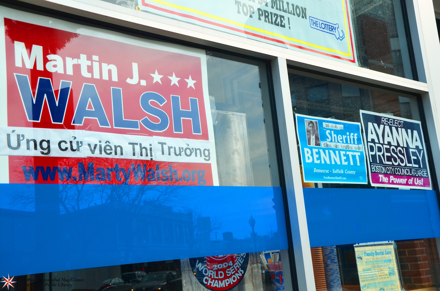
Lisa Cordner.
Marty Walsh for Mayor (Fields Corner)
Boston, 2014
Courtesy Lisa Cordner Images
Residents from Vietnam make up the largest group of immigrants in Dorchester and the fourth largest foreign-born group in Boston as a whole. Fields Corner is the center of this community and home to the first Vietnamese community center in America as well as numerous Vietnamese owned businesses and restaurants. The 2013 Boston mayoral race saw various immigrant communities in Boston building grassroots campaigns for candidates, including Mayor Martin J. Walsh, the son of Irish immigrants himself.
Los residentes de Vietnam constituyen el grupo más grande de inmigrantes en Dorchester y el cuarto grupo más grande de origen extranjero en Boston en su conjunto. Fields Corner es el centro de esta comunidad y el hogar del primer centro de la comunidad vietnamita en Estados Unidos, así como también numerosos vietnamitas son propietarios de negocios y restaurantes. La competencia electoral por la alcaldía de Boston 2013 vio a diversas comunidades de inmigrantes en Boston formando parte de las bases de las campañas para los candidatos, entre ellos el alcalde Martin J. Walsh, quien es hijo de inmigrantes irlandeses.
Rezidan ki soti nan Vyetnam konpoze pi gwo gwoup imigran nan Dorchester ak katriyèm pi gwo gwoup la ki fèt aletranje nan Boston tout antye. Fields Corner se sant lan nan kominote sa a ak kay pou premye sant kominotè Vyetnamyen nan Amerika osibyen ke anpil biznis ak restoran ki posede pa Vyetnamyen. Kous pou lameri 2013 Boston an te wè divès kalite kominote imigran nan Boston k’ap bati rasin kanpay pou kandida, ki gen ladan Majistra Martin J. Walsh, pitit pitit imigran Ilandè li menm.
来自越南的居民组成了多切斯特最大的移民群体和全波士顿第四大外国出生群体. 场角是该城区的中心, 是美国第一个越南人社区中心, 它有许多越南人拥有的商业和餐馆. 2013年波士顿市长竞选中, 可以看到波士顿中的不同移民社区为候选人建立基层民众竞选活动, 包括市长马丁•华殊, 他本人是爱尔兰移民的儿子.
Lisa Cordner.
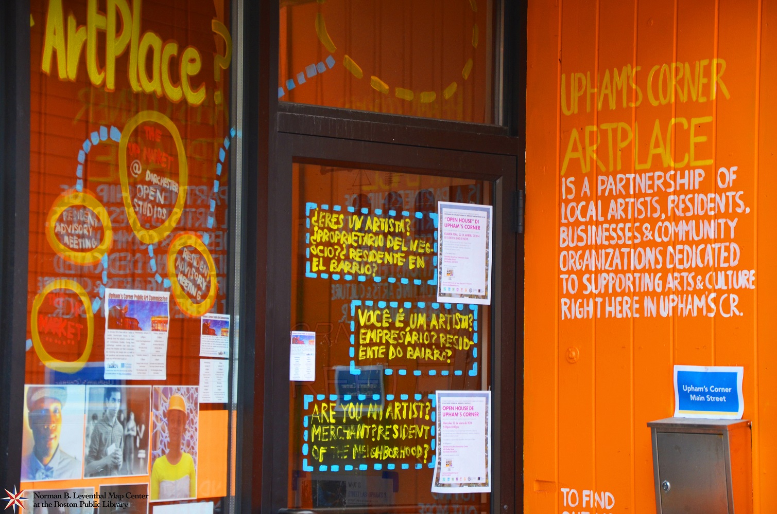
Uphams Corner Artplace
Boston, 2014
Courtesy Lisa Cordner Images
The arts play an important role in the life of every Boston neighborhood, connecting residents with a variety of cultures and creating more vibrant communities. Uphams Corner Artplace is one example of an organization dedicated to supporting “ local creative economy” by working with residents, artists, community organizations and businesses. The entrance signage reflects the diversity of languages spoken by local residents in the neighborhood.
Las artes desempeñan un papel importante en la vida de cada vecindad de Boston, conectando a los residentes con una variedad de culturas y creando comunidades más vibrantes. Uphams Corner Artplace es un ejemplo de una organización dedicada a apoyar la “economía creativa local” trabajando con los residentes, los artistas, las organizaciones de la comunidad y los negocios. La señalización de entrada refleja la diversidad de los idiomas hablados por los residentes locales en la vecindad.
Atizay yo jwe yon wòl enpòtan nan lavi chak katye Boston, nan konekte rezidan yo avèk yon varyete de kilti epi kreye kominote ki pi vanyan. Uphams Corner Artplace se yon egzanp de yon òganizasyon ki dedye a sipòte “ekonomi kreyatif lokal” nan travay ak rezidan yo, atis, òganizasyon kominotè ak biznis yo. Pankat nan antre a reflete divèsite nan lang ki pale pa rezidan lokal nan katye yo.
艺术对波士顿每一个城区的生活发挥着重要的作用, 它把居民与各种文化连接在一起和创造更加充满活力的社区. 阿巴汗思角艺术天地是专门支持”本地创意经济”与居民, 艺术家, 社区组织和商业合作组织的一个例子, 它的入口指示牌反映了当地城区居民使用的多种语言.
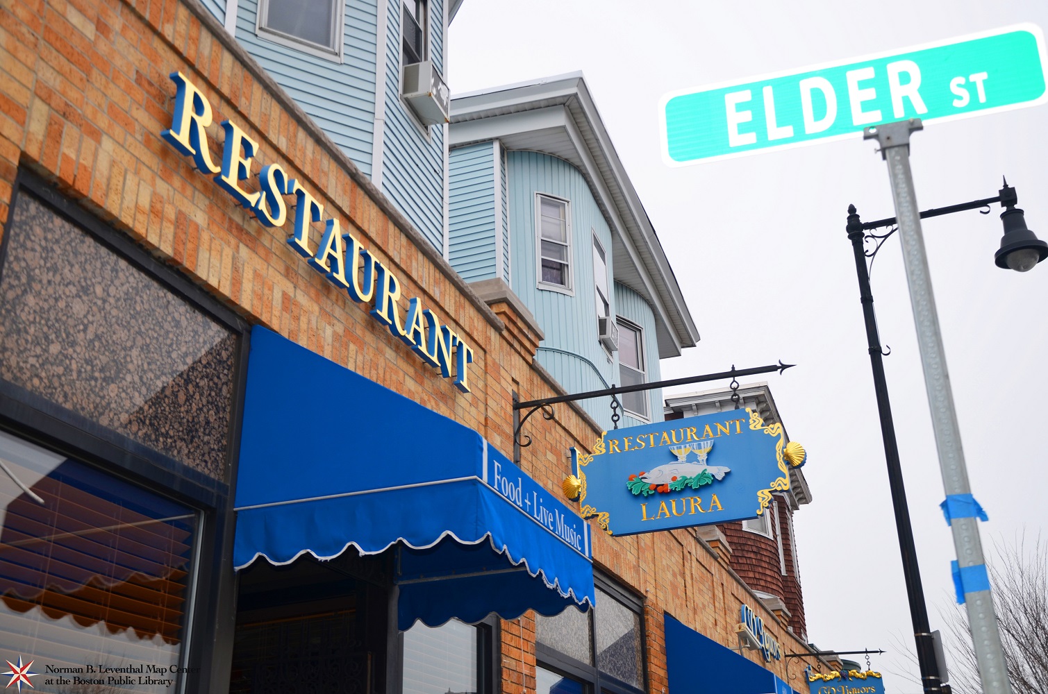
Lisa Cordner.
Restaurant Laura (Uphams Corner)
Boston, 2014
Courtesy Lisa Cordner Images
Uphams Corner is the main home of the Cape Verdean community in Boston. Cape Verdeans have a long history in Massachusetts, first arriving in the 1800s to work in the whaling industry. Thousands more arrived after 1975 when Cape Verde earned its independence from Portugal. Today, there are over 6,500 Cape Verdean residents in Boston. Restaurant Laura, one of several Cape Verdean restaurants in Uphams Corner serves a traditional menu, a combination of influences from Portuguese and African cuisine.
Uphams Corner es la sede principal de la comunidad caboverdiana en Boston. Los caboverdianos tienen una larga historia en Massachusetts, llegó por primera vez en la década de 1800 para trabajar en la industria ballenera. Miles más llegaron después de 1975 cuando Cabo Verde obtuvo su independencia de Portugal. Hoy en día, hay más de 6.500 residentes caboverdianos en Boston. El Restaurante Laura, uno de los varios restaurantes caboverdianos en Uphams Corner sirve un menú tradicional, una combinación de influencias de la cocina portuguesa y africana.
Uphams Corner se kay prensipal kominote Kap Vèdyen an nan Boston. Kap Vèdyen yo gen yon istwa long nan Massachusetts, premye moun yo ki te rive nan ane 1800 yo pou travay nan endistri balèn nan. Dè milye anplis te rive apre 1975 lè Kap Vèd te pran endepandans li nan men Pòtigal. Jodi a, gen plis pase 6,500 Kap Vèdyen rezidan nan Boston. Restaurant Laura, youn nan plizyè Kap Vèdyen restoran nan Uphams Corner sèvi yon meni tradisyonèl, yon konbinezon de enfliyans soti nan kizin Pòtigè ak Afriken.
阿巴汗思角是佛得角人在波士顿的主要社区.佛得角人在马萨诸塞州有着悠久的历史, 首批到达的移民是在19世纪, 那时他们从事捕鲸业工作.在1975年, 佛得角脱离葡萄牙统治取得独立后, 数千名佛得角人来到马塞诸塞州. 今天, 住在波士顿的佛得角人已超过6,500. 劳拉餐厅, 是座落在阿巴汗思角中几间佛得角餐厅的其中一间, 餐厅供应佛得角传统菜单, 其菜色受到葡萄牙和非洲美食影响.
Lisa Cordner.
Boston Public School Lottery Announcement in Haitian Creole (Mattapan Center)
Boston, 2014
Courtesy Lisa Cordner Images
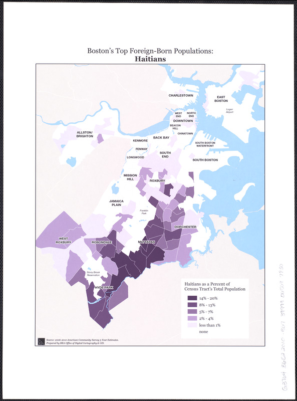
While Blue Hill Avenue includes much of the ethnic and cultural diversity of Boston, Mattapan Center is the heart of the Haitian community. Massachusetts has the third largest Haitian community in the United States, after Florida and New York, and almost 14,000 Haitians call Boston home. More than 18% of Mattapan residents speak French or Haitian Creole at home.
Aunque Blue Hill Avenue incluye gran parte de la diversidad étnica y cultural de Boston, Mattapan Center es el corazón de la comunidad haitiana. Massachusetts tiene la tercera comunidad haitiana más grande en los Estados Unidos, después de la Florida y Nueva York, casi 14.000 haitianos llaman a Boston su hogar. Más del 18% de los residentes de Mattapan hablan francés o criollo haitiano en casa.
Pandan ke Blue Hill Avenue gen ladan anpil nan divèsite etnik ak kiltirèl nan Boston, Mattapan Center se kè kominote ayisyen an. Massachusetts gen twazyèm pi gwo kominote ayisyen nan Etazini yo, apre Florida ak New York, epi prèske 14,000 Ayisyen rele Boston kay yo. Plis pase 18% moun ki abite Mattapan pale fransè oswa kreyòl ayisyen lakay yo.
蓝山大道包括了波士顿不同的种族和多元文化,而马他畔中心是海地社区的心脏. 马塞诸塞州的海地社区人数在美国排行第三, 紧跟佛罗里达州和纽约之后, 差不多14,000 海地人称波士顿是他们的家园. 18%以上的马他畔居民在家里讲法语或海地克里奥尔语.
5. Blue Hill Avenue
From the early 1900s through the 1950s, the neighborhoods around Blue Hill Avenue formed the heart of Boston’s Jewish community, at one point encompassing 77,000 people of Jewish ethnicity, or half Boston’s Jewish population. Blue Hill Avenue, from the Elm Hill and Grove Hall sections of Roxbury, through the Franklin Park, Franklin Field and Mt. Bowdoin sections of Dorchester and into Mattapan, formed the spine of the community with businesses, synagogues and social service organizations all along. After World War II, African American families, many from the southern United States, moved in to these same neighborhoods, more than doubling the population of Boston’s black community to 63,000 by 1960. Today, Blue Hill Avenue continues as a major commercial corridor and encompasses diversity in every sense along its path.
Desde los comienzos de los 1900 hasta la década de 1950, las vecindades alrededor de Blue Hill Avenue formaron el corazón de la comunidad judía de Boston, a tal punto que abarcaba a 77.000 personas de etnia judía o la mitad de la población judía de Boston. Blue Hill Avenue, desde los sectores de Elm Hill y Grove Hall de Roxbury a través de Franklin Park, Franklin Field y los sectores de Mt. Bowdoin de Dorchester y en Mattapan, formaron desde un principio la columna vertebral de la comunidad con negocios, sinagogas y organizaciones de servicio social. Después de la Segunda Guerra Mundial, las familias afroamericanas, muchas de ellas del sur de los Estados Unidos, se mudaron a estos mismos vecindarios más que duplicando la población de la comunidad negra de Boston a 63.000 en 1960. Hoy, Blue Hill Avenue continúa como un corredor comercial importante y abarca la diversidad en todos los sentidos a lo largo de su trayectoria.
Soti nan kòmansman ane 1900 yo rive nan 1950 yo, katye yo ozalantou Blue Hill Avenue te fòme kè kominote jwif Boston an, nan yon tan te anglobe 77,000 moun ki gen etnisite jwif, oswa mwatye popilasyon jwif nan Boston. Blue Hill Avenue, ki soti nan seksyon Elm Hill ak seksyon Grove Hall nan Roxbury, atravè Franklin Park, Franklin Field ak Seksyon Mt. Bowdoin nan Dorchester, ak nan Mattapan, te fòme poto mitan kominote a ak biznis yo, sinagòg ak òganizasyon sèvis sosyal yo tout ansanm. Apre Dezyèm Gè Mondyal la, fanmi Afriken-Ameriken, anpil ladan yo soti nan sid peyi Etazini, te deplase vin nan menm katye sa yo, pi plis ke double popilasyon an nan kominote nwa Boston yo a 63.000 apati 1960. Jodi a, Blue Hill Avenue ap kontinye kòm yon gwo koridò komèsyal ak anglobe divèsite nan tout sans nan chemen li.
从20世纪初至20世纪50年代, 蓝山大道的各个街区形成了波士顿的犹太社区核心地带, 曾一度有77,000人是犹太种族,或占波士顿犹太人口的一半. 蓝山大道, 从罗克斯伯里的榆树山和林塘路段, 通过多切斯特的富兰克林公园, 富兰克林广场和漫.鲍登地段, 进入马他畔, 形成商业, 犹太教堂和社会服务机构的社区脊柱. 在第二次世界大战后, 许多来自美国南部的非洲裔美国人家庭, 搬进这一带城区, 到1960年, 波士顿的黑人社区人口倍增, 曾至63,000人. 如今, 蓝山大道继续作为一个主要的商业地段, 囊括着不同感觉的多元文化.
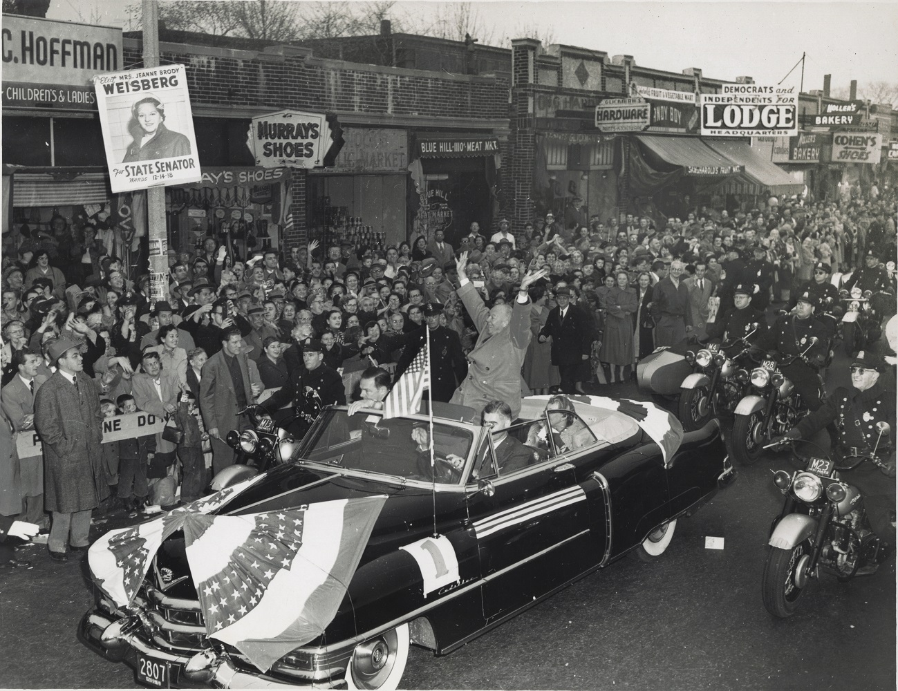
Boston Herald-Traveler.
Ike on Blue Hill Avenue During Boston Visit, 1952
Boston, [1952]
Courtesy of the Trustees of the Boston Public Library, Print Department
This photograph captures a snapshot of life and streetscape in the heart of 1950s Jewish Boston. General Dwight D. Eisenhower campaigns for Massachusetts Republican Senate candidate Henry Cabot Lodge (in front seat), who lost the race to a young John F. Kennedy. Along with many Jewish-owned businesses, the photo shows the campaign poster for Jeanne Brody Weisberg, an attorney and Jewish Massachusetts state senate candidate.
Esta fotografía captura una instantánea de la vida y paisaje urbano en el corazón del Boston judío de los 1950. El General Dwight D. Eisenhower en las campañas a favor de Henry Cabot Lodge (en el asiento delantero) candidato republicano al Senado de Massachusetts, que perdió la elección ante el joven John F. Kennedy. Junto con muchos propietarios de negocios judíos, la foto muestra el cartel de la campaña para Jeanne Brody Weisberg, un abogado judio y candidata al Senado del Estado de Massachusetts.
Foto sa a kaptire yon enstantane nan lavi ak peyizaj nan kè jwif Boston nan ane 1950. Jeneral Dwight D. Eisenhower te fè kanpay pou Henry Cabot Lodge kandida Sena Repibliken Massachusetts (nan chèz devan an), ki te pèdi kous la devan yon jèn John F. Kennedy. Ansanm ak anpil biznis jwif yo posede, foto a montre afich kanpay pou Jeanne Brody Weisberg, yon avoka epi kandida jwif sena eta Massachusetts.
这张照片捕捉了波士顿犹太人在20世纪50年代的生活和街景中心. 艾森豪威尔将军参加美国马萨诸塞州共和党参议员候选人亨利•卡伯特•洛奇(前排座椅)的竞选活动, 在这场竞选中, 亨利•卡伯特•洛奇输给了年轻的约翰•F•肯尼迪. 照片里除了显示有许多犹太人拥有的商业外, 还显示了珍妮•布罗迪•韦斯伯格的竞选海报, 她是犹太人, 是一名律师和是马萨诸塞州参议员候选人.
Lisa Cordner.
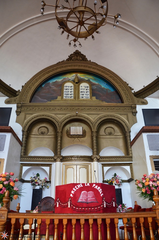
First Haitian Baptist Church Exterior
Boston, 2014
Courtesy Lisa Cordner Images
Lisa Cordner.
First Haitian Baptist Church Interior
Boston, 2014
Courtesy Lisa Cordner Images
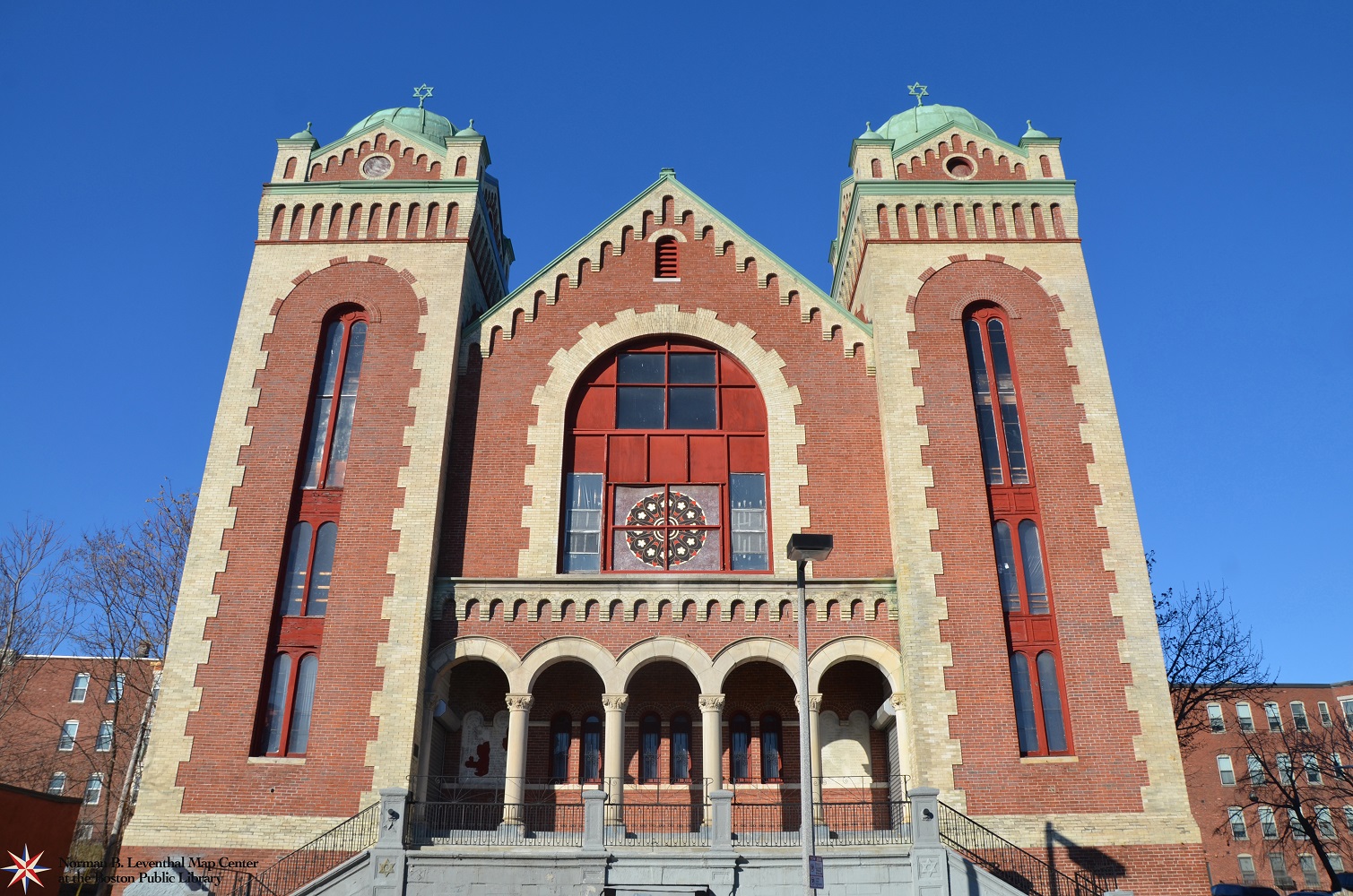
Adath Jeshurun synagogue was founded in 1894 and moved to the Grove Hall-Blue Hill Avenue district in 1900. This structure at 397 Blue Hill Avenue was built in 1906 by a congregation of 140 families at a cost of almost $150,000. By the early 1960s, the Jewish population around Blue Hill Avenue and the synagogue’s congregation had dwindled as Jewish residents moved to outlying suburbs. As the Grove Hall area was increasingly becoming home to African American, Caribbean and Latino communities, the building was purchased in 1967 by Ecclesia Apolostica, and then by the First Haitian Baptist Church in 1978 who restored and still occupy the building today.
La sinagoga Adath Jeshurun fue fundada en 1894 y se trasladó al distrito de Grove Hall-Blue Hill Avenue en 1900. Esta estructura en el 397 Blue Hill Avenue fue construida en 1906 por una congregación de 140 familias a un costo de casi $150.000. A principios de la década de 1960, la población judía alrededor de Blue Hill Avenue y la congregación de la sinagoga se habían reducido ya que los residentes judíos se mudaron a los barrios residenciales de las afueras. A medida que el área de Grove Hill fue haciéndose cada vez más el hogar de las comunidades afroamericanas, caribeñas y latinas, el edificio fue comprado en 1967 por Ecclesia Apolostica y luego por la Primera Iglesia Bautista haitiana en 1978 quién restauró y todavía hoy ocupa el edificio.
Sinagòg Adath Jeshurun te fonde nan ane 1894 epi demenaje ale nan distri Grove Hall-Blue Hill Avenue nan ane 1900. Konstriksyon sa a nan 397 Blue Hill Avenue an te bati nan ane 1906 pa yon kongregasyon 140 fanmi a yon pri nan prèske $150,000. Apati kòmansman ane 1960 yo, popilasyon jwif alantou Blue Hill Avenue ak kongregasyon sinagòg la te diminye lòske jwif te demenaje ale rete nan zòn banlye sou kote yo. Kòm zòn Grove Hall la te de pli zan pli vin kay pou Afriken-Ameriken, kominote Karayibeyen ak kominote Latino yo, konstriksyon an te achte an 1967 pa Ecclesia Apolostica, epi pa First Haitian Baptist Church nan lane 1978 ki te restore l’ epi toujou rete nan konstriksyon an jodi a.
阿达•叶舒伦犹太教堂始建于1894年, 1900年搬到林塘-蓝山大道区. 这座座落在397号蓝山大道的建筑建于1906年, 建筑费用近15万元, 到教堂做礼拜的人有140个家庭. 到了20世纪60年代初, 由於犹太居民搬到偏远的郊区, 围绕蓝山大道的犹太人口和到犹太教堂的会众已经逐渐减少. 随着林塘逐渐成为非裔美国人, 加勒比和拉丁裔社区的家园, 在1967年, 这座教堂被厄瓜里思•阿波斯涛里卡购买, 然后在1978年被海地第一浸信会购买, 海地第一浸信会购买该教堂后, 对教堂进行了修复, 至今, 他们仍然使用这座教堂.
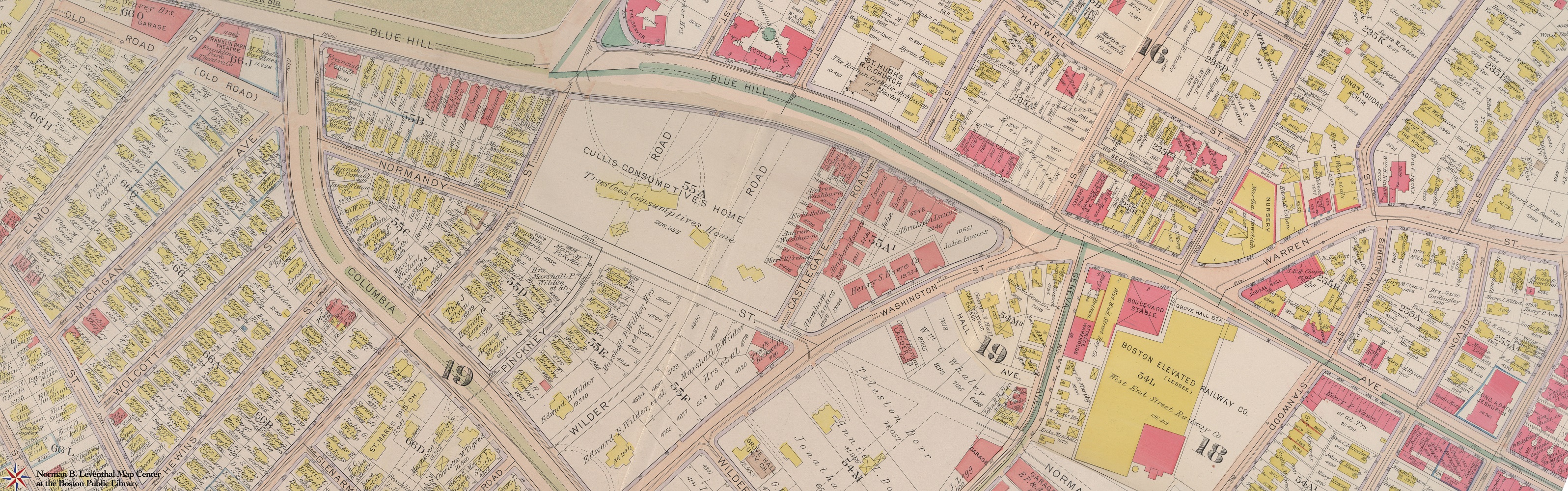
G.W. Bromley & Co.
Plates: Dorchester 1918 (13, 14, 15), Roxbury 1915 (plates 30, 31), West Roxbury, 1924 (plate 12)
Philadelphia, 1915-1924
The civil engineering firm of G.W. Bromley & Co. produced detailed atlases of Boston from 1883 to 1938 for real estate purposes. This modern combination of plates covers the neighborhoods around Blue Hill Avenue in Dorchester and Roxbury. A close inspection of property owners shows the large number of Jewish property and business owners in the area as well as area synagogues. Map Center founder Norman B. Leventhal was born and grew up during the 1920s and 30s at 18 Wolcott Street in Dorchester, shown on this view.
La firma de ingeniería civil G.W. Bromley & Co. produjo atlas detallados de Boston desde 1883 hasta 1938 con fines inmobiliarios. Esta moderna combinación de placas cubre las vecindades alrededor de Blue Hill Avenue en Dorchester y Roxbury. Una inspección minuciosa de los dueños de propiedades muestra el gran número de propiedades y dueños de negocios judíos en el área así como las sinagogas del área. Norman B. Leventhal fundador de Map Center nació y creció en 18 Wolcott Street en Dorchester, mostrado en esta visita durante las décadas de 1920 y 1930.
Kabinè jeni sivil G.W. Bromley & Co pwodui atlas detaye Boston soti nan 1883 rive nan 1938 pou rezon byen imobilye. Konbinezon modèn plak sa a kouvri katye ozalantou Blue Hill Avenue yo nan Dorchester ak Roxbury. Yon enspeksyon atantif de mèt pwopriyete yo montre gwo kantite pwopriyete jwif ak mèt biznis nan zòn nan osibyen ke sinagòg nan zòn nan. Fondatè Map Center Norman B. Leventhal te fèt epi grandi nan 18 Wolcott Street nan Dorchester, yo montre sou vi sa a, pandan ane 1920 ak 30 yo.
从1883年至1938年间, G.W.布罗姆利土木工程公司生产用于房地产的波士顿详细地图册. 这一现代图版组合覆盖了多切斯特和罗克斯伯里围绕蓝山大道的城区. 对业主进行仔细的查看, 显示出这一地区有大量的犹太人财产和商业业主以及犹太教堂. 地图中心创始人诺曼• B•利文撒尔在多切斯特18号沃尔科特街出生并长大, 这个视图显示了这一房子在20世纪20年代和30年代期间.
6. Chinatown
In the early 1800s, the area where Boston’s Chinatown exists today was an ocean tidal flat – a wet, marshy area with no homes or businesses. In the 1830s, fifty-five acres in the location known as South Cove were filled in to accommodate the growing population and railroad, shipping, and manufacturing industries. Successive waves of immigrants from Ireland, Eastern and Southern Europe and Syria lived in the neighborhood starting in the 1840s, with Chinese immigrants arriving in the 1870s. By the 1880s, Chinatown was the social and economic center for Chinese in the region.
A principios de 1800, el área donde hoy existe el barrio chino de Boston fue una parte plana de la marea del océano, una zona húmeda, pantanosa sin casas ni negocios. En la década de 1830, cincuenta y cinco acres en el sitio conocido como South Cove fueron rellenadas para dar cabida al crecimiento del ferrocarril, transporte y las industrias manufactureras. La gente de Europa y Siria se instalaron primero en la región en la década de 1840, los inmigrantes chinos llegaron en la década de 1870. Para la década de 1890, la comunidad china se había establecido firmemente en la zona con empresarios que aperturaban una variedad de negocios y organizaciones. Después de la Segunda Guerra Mundial las familias chinas se establecieron en la comunidad e hicieron de la vecindad su hogar.
Nan kòmansman ane 1800 yo, zòn kote Chinatown Boston egziste jodi a te yon oseyan mare plat – yon zòn mouye, marekaj ki pa t’ gen okenn kay oswa biznis. Nan 1830s yo, senkant-senk kawo tè nan kote ki te konnen kòm South Cove te bouche pou akomode ray tren ki t’ap grandi, transpò, ak endistri fabrikasyon yo. Moun ki soti nan Ewòp ak peyi Siri te premye etabli nan rejyon an nan ane 1840 yo, avèk imigran Chinwa ki te rive nan 1870s yo. Apati lane 1890 yo, kominote Chinwa a te fèmeman etabli pwòp tèt li nan zòn nan ak antreprenè nan louvri yon varyete de biznis ak òganizasyon. Apre Dezyèm Gè Mondyal la, fanmi Chinwa te etabli nan kominote a epi te fè katye a tounen kay yo.
在19世纪初, 当今波士顿的唐人街是一个海洋泥滩 – 一个潮湿, 沼泽地区, 没有家庭或商业. 在19世纪30年代, 为适应不断增长的铁路, 航运和制造业, 在被称为南湾的地方填充了55英亩地. 在19世纪40年代, 来自欧洲和叙利亚的移民首先在该地区落户, 中国移民在19世纪70年代开始抵达. 到了19世纪90年代, 中国人已经在该区确立了自己的社区, 与企业家开设各种商业和组织. 第二次世界大战结束后,中国家庭在该城区落户, 让该城区成为他们的家园.
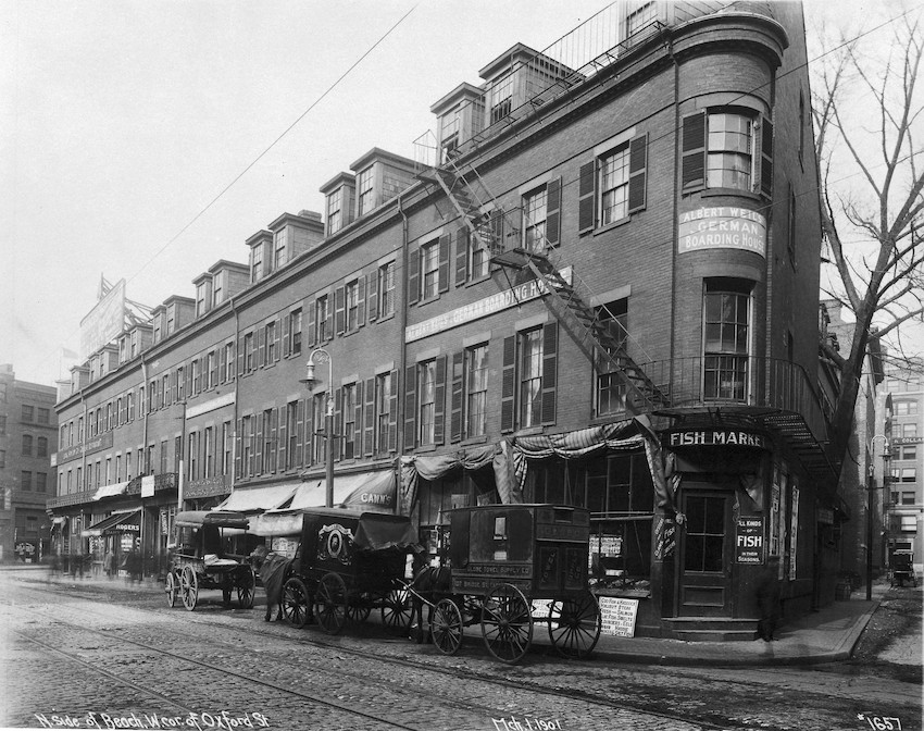
North Side of Beach Street, West Corner of Oxford Street
Boston, 1901
Courtesy Historic New England
Lisa Cordner.
View of Beach and Tyler Streets
Boston, 2014
Courtesy Lisa Cordner Images
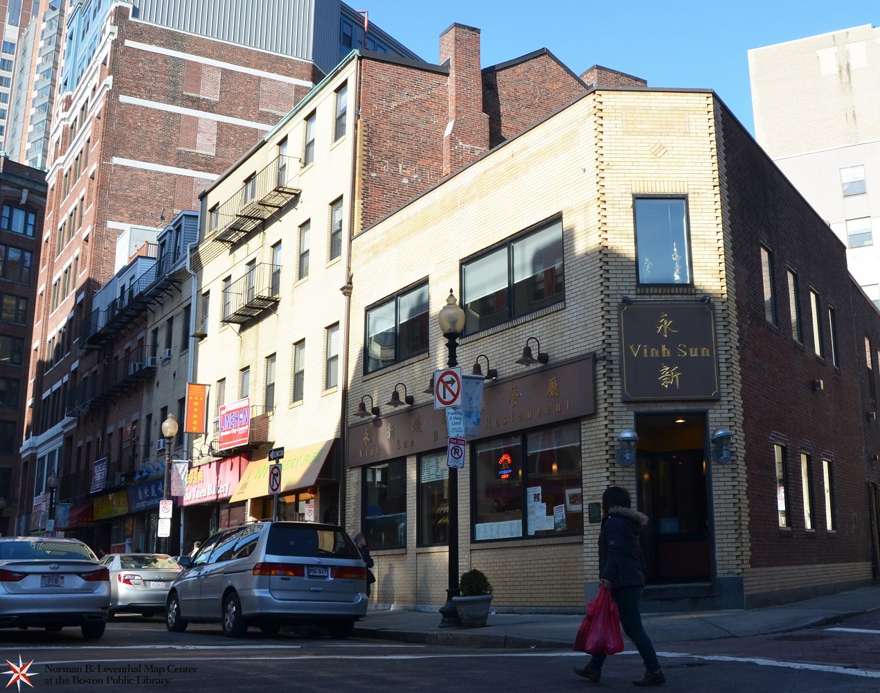
In the early 1900s, the Chinese population in Chinatown was about 300 and in Boston nearly 500. The heart of the community was on Harrison Avenue. As seen in the top photograph, only a few Chinese businesses were located on Beach Street at this time. Carriages are parked near the “German Boarding House” at the corner of Beach and Oxford Streets. Chinese-owned businesses grew in the area throughout the following decades. Boston is now home to over 42,000 people who were born in Asian countries. As seen in the modern photograph of Beach Street just below, Asian businesses line the road today, and the buildings have grown much taller as space becomes more valuable.
En los inicios de la década de 1900, la población china en Boston ascendió a casi 500 personas. Como se ve en la fotografía superior, en ese momento, en el corazón de Chinatown varios negocios estaban situados en Beach Street. Carruajes se estacionaban cerca de un mercado de pescado en la esquina de las calles Beach y Tyler. Los negocios de propietarios chinos crecieron en el área a lo largo de las siguientes décadas. Boston es ahora el hogar de más de 42.000 personas que nacieron en países asiáticos. Como se ve a continuación en la moderna fotografía de Beach Street, los negocios asiáticos llenan hoy las calles y los edificios se han hecho mucho más altos a medida que el espacio se vuelve más valioso.
Nan kòmansman ane 1900 yo, popilasyon Chinwa a nan Boston te totalize prèske 500 moun. Jan nou kapab wè l’ nan foto anlè a, plizyè biznis te chita sou Beach Street nan moman sa a, nan kè Chinatown. plas pou Chari yo tou pre yon mache pwason nan kwen Beach ak Tyler Streets. Biznis ki posede pa Chinwa te grandi nan zòn nan atravè tout deseni ki swiv yo. Boston se kounye a kay pou plis pase 42,000 moun ki te fèt nan peyi Azyatik yo. Jan nou ka wè nan foto modèn Beach Street la jis anba a, biznis Azyatik aliyen sou tout wout la jodi a, epi konstriksyon yo te ogmante plis nan wotè pandan ke espas vini gen plis valè.
在20世纪初, 中国人口在波士顿共计近500人. 从上面的照片看到, 当时有几个商业分布在唐人街的中心, 必珠街. 马车停靠在必珠街和泰勒街拐角处的鱼市场附近. 在之后的几十年, 中国人在这里开办的生意不断成长.波士顿现在有超过42,000人出生在亚洲国家. 在下方必珠街的现代照片可见, 现今的街道沿路都是亚洲人生意,建筑物比以前高很多, 因为地价比以前贵得多了.
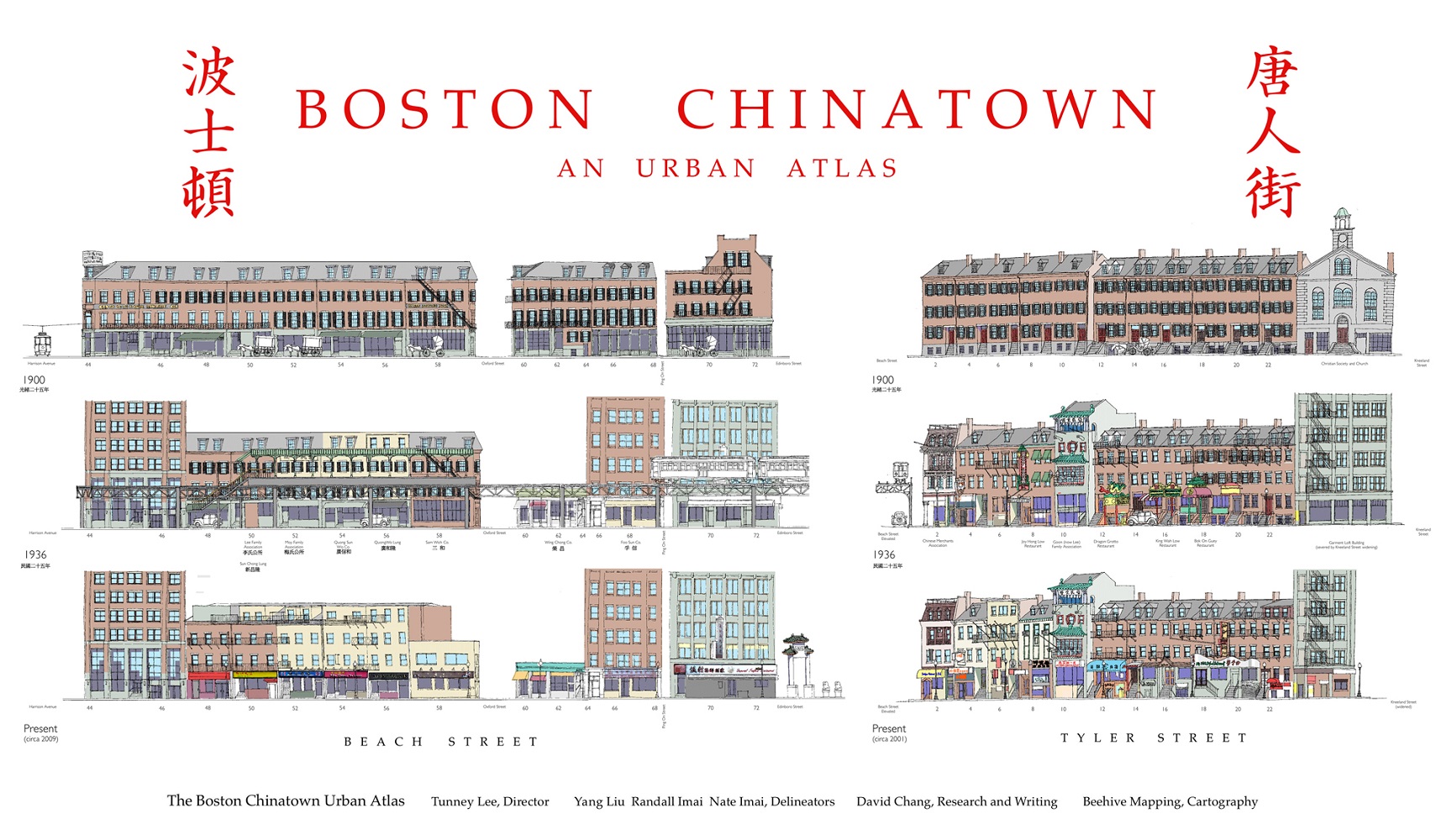
Tunney Lee, Randall Imai, et al.
Elevations of Beach and Tyler Streets, from The Boston Chinatown Urban Atlas
[2013]
Reproduction Courtesy Tunney Lee and Randall Imai
The look of Beach and Tyler Streets has changed dramatically over the last 100 years. These illustrations from the Boston Chinatown Urban Atlas show the change of the area over time, as do the photographs to the left. In 1900, there was a small Chinese population in the neighborhood, and there were a handful of restaurants, as well as many apartments. By 1936 over 800 Chinese lived in the area, and more restaurants and associations appeared. Seventy years later, Asian businesses still predominate in the neighborhood, as Chinatown is now home to Chinese and Vietnamese establishments.
El aspecto de las calles Beach y Tyler ha cambiado de manera drástica en los últimos 100 años. Estas ilustraciones del Atlas Urbano de Chinatown de Boston muestran como ha cambiado la zona con el tiempo, al igual que las fotografías de la izquierda. En 1900 hubo una pequeña población china en la vecindad y había unos pocos restaurantes así como muchos apartamentos. En 1936 más de 1.000 chinos vivían en la zona y aparecieron más restaurantes y asociaciones. Setenta años más tarde, los negocios asiáticos todavía predominan en la vecindad ya que Chinatown es ahora el hogar de establecimientos chinos, vietnamitas y camboyanos.
Vizaj Beach ak Tyler Street te chanje dramatikman nan 100 dènye ane ki pase yo. Ilistrasyon sa yo ki soti nan Boston Chinatown Urban Atlas yo montre chanjman nan zòn nan atravè letan, menm jan foto yo sou bò goch la fè l’. Nan ane 1900, te gen yon ti popilasyon Chinwa nan katye a, epi te gen yon ti ponyen restoran, osi byen ke plizyèl apatman. Apati 1936 plis pase 1,000 Chinwa te rete nan zòn lan, epi plis restoran ak asosyasyon te vin parèt. Swasanndis ane pita, biznis Azyatik toujou ap renye nan katye a, menm jan Chinatown se kounye kay pou Chinwa, Vyetnamyen ak etablisman Kanbodyen.
在过去100年,必珠街和泰勒街的面貌发生了巨大变化. 这些波士顿唐人街地图集插图和左侧的照片显示了这些年来这里发生的变化. 在1900年, 唐人街中国人不多, 有几家餐馆, 有许多公寓. 到1936年, 在这里居住的中国人数超过1000人, 这时涌现出更多的餐馆和协会. 七十年后, 亚洲商业在唐人街仍然占主导地位, 现在的唐人街是中国, 越南和柬埔寨商店的聚集点.
Lisa Cordner.
Scenes of Modern-Day Chinatown
Boston, 2014
Courtesy Lisa Cordner Images
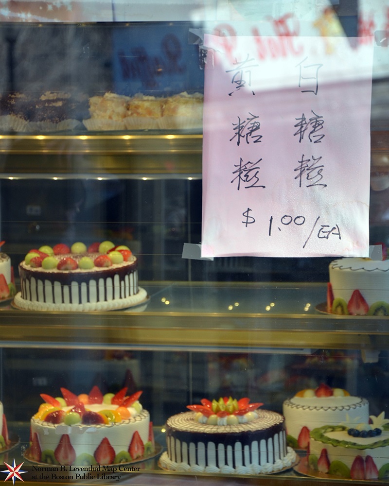
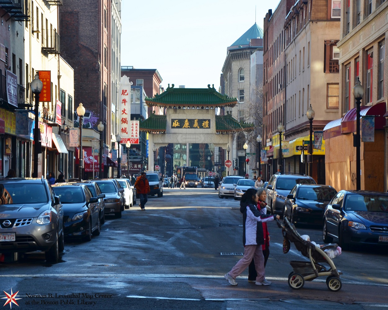
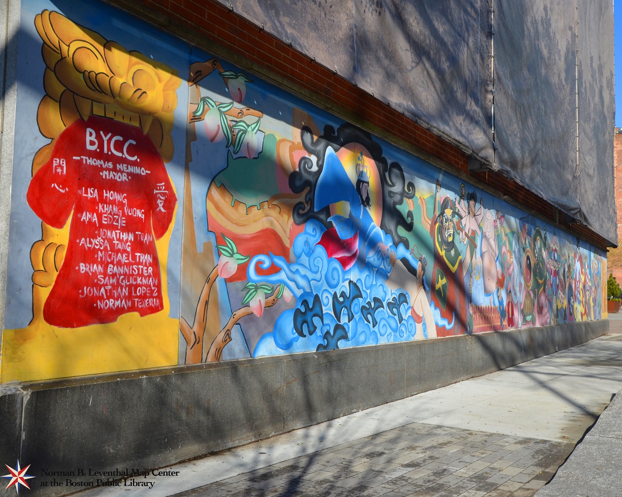
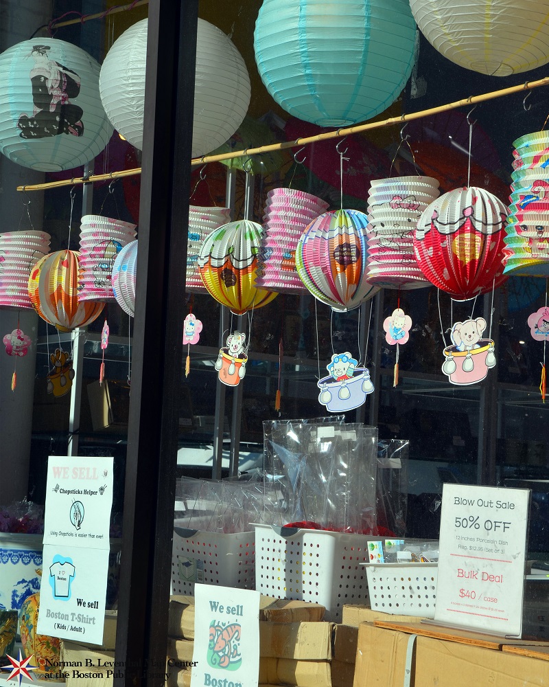
These four modern photographs offer a glimpse into what Chinatown looks like in the present. Today, over 18,000 Bostonians were born in China, and nearly 9% of Boston’s total population is of Asian descent. The grand gateway arch at Beach and Hudson Streets displayed here welcomes people into Chinatown. Businesses such as bakeries and souvenir shops supply goods to customers in the neighborhood and beyond, and a colorful mural painted by the Boston Youth Clean-up Corps, located near the Chinatown gate, celebrates Chinese art and culture.
Estas cuatro fotografías modernas ofrecen una visión de cómo se ve Chinatown en el presente. Hoy en día, más de 18.000 bostonianos han nacido en China y casi el 9% de la población total de Boston es de ascendencia asiática. El gran arco de la puerta de enlace en las calles Beach y Hudson exhibido aquí da la bienvenida a la gente a Chinatown. Negocios como panaderías y de tiendas de recuerdos suministran bienes a los clientes de la vecindad y de más allá y un colorido mural pintado por Youth Clean-up Corps de Boston, situado cerca de la puerta de Chinatown, celebra el arte y la cultura china.
Kat foto modèn sa yo ofri yon apèsi nan sa ke Chinatown sanble nan tan prezan an. Jodi a, plis pase 18,000 Bostonyen te fèt nan peyi Lachin, epi prèske 9% popilasyon total Boston gen desandans Azyatik. Gwo ark pòtay la nan Beach ak Hudson Streets ki demontre la akeyi moun nan Chinatown. Biznis tankou boulanjri ak boutik souvni founi machandiz pou kliyan nan katye a epi pi lwen pase sa a, ak yon miral kolore pentire pa Boston Youth Clean-up Corps, sitiye tou pre bò pòtay Chinatown, selebre atizay ak kilti Chinwa.
通过这四张现代照片, 一瞥当今唐人街风貌. 现在, 有超过18,000名波士顿人是在中国出生的, 和将近9%的波士顿总人口是亚裔. 屹立在必珠街和哈德逊街交汇之处的壮观的拱门, 表示在这里欢迎人们到唐人街. 这里的商业如面包店和纪念品商店为城区内外的顾客供应货物, 一幅由波士顿青年清理军团画的色彩斑斓的壁画, 位于唐人街大门附近, 庆祝中国艺术和文化.
Tunney Lee, Randall Imai, et al.
Maps Showing Physical Changes in Chinatown, from The Boston Chinatown Urban Atlas
[2013]
Reproduction Courtesy Tunney Lee and Randall Imai
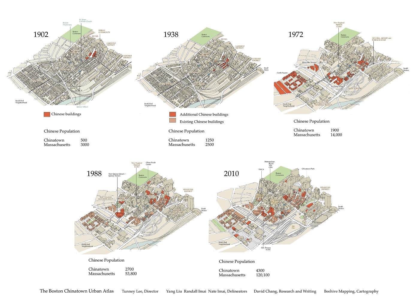
As the Chinese population has increased in the city of Boston over the last century, the geography and architecture of the neighborhood have also changed. As seen in these five maps of the area over time, Chinese buildings were few in number when the population was only 300. Over the years, as the number of Chinese residents increased in the neighborhood, buildings moved from a central location, to being more spread-out. Urban development and construction of two major highways in the area during the 1960s greatly impacted the community, and the neighborhood has since expanded into the South End. With nearly 4,000 Chinese residents living in Boston’s downtown neighborhoods, Chinatown continues to provide a home for new immigrants to the city.
Debido a que en el último siglo la población china ha aumentado en la ciudad de Boston, también ha cambiado la geografía y la arquitectura de la vecindad. Como se ve en estos cinco mapas de la zona a través del tiempo, los edificios chinos eran pocos en número cuando la población era sólo de 500. Con los años, debido a que el número de residentes chinos se incrementó en la vecindad, los edificios se movieron desde una ubicación central para estar más espaciados. El desarrollo urbano y la construcción de dos carreteras principales en la zona durante los años de la década de 1960 afectaron en gran medida a la comunidad y desde entonces la vecindad se ha expandido hacia el South End. Con cerca de 4.000 residentes chinos viviendo en las vecindades del centro de Boston, Chinatown continúa proporcionando un hogar a los nuevos inmigrantes a la ciudad.
Kòm popilasyon Chinwa a te ogmante nan vil Boston atravè dènye syèk la, jewografi ak achitekti nan katye a te chanje tou. Jan nou ka wè l’ sou senk kat jeyografik sa yo nan zòn nan atravè letan, konstriksyon Chinwa yo te an ti kantite lè popilasyon an te sèlman 500 moun. Atravè letan, kòm kantite rezidan Chinwa yo te ogmante nan katye a, konstriksyon yo te deplase soti nan yon kote santral, pou ale vin pi epapiye. Devlopman iben ak konstriksyon de gwo otowout nan zòn nan pandan ane 1960 yo te vin grandman afekte kominote a, epi katye a depi lè sa te etann li rive nan South End lan. Ak prèske 4,000 rezidan Chinwa k’ap viv nan katye downtown Boston, Chinatown kontinye founi kay pou nouvo imigran nan lavil la.
随着上一世纪 波士顿市的中国人口不断增加, 城区的布局和架构也随之而发生了变化. 从 这五张随着时间推移的该区地图看出, 当人口只有500人时, 中国人的楼房建筑为数不多. 多年来, 随着城区中国居民人口增加, 楼房建筑已从集中的中央位置向外散出发展. 在20世纪60年代期间, 在这地区的两大高速公路城市发展和建设,极大地影响了该社区, 从那时起, 该城区已经扩展到南区. 有近4000名中国居民居住在波士顿市中心的城区, 唐人街继续为这座城市的新移民提供一个家园.
Exhibition Photos
Bibliography
Allison, Robert J. A Short History of Boston. Beverly, MA. Commonwealth Editions, 2004.
Boston 200 Corporation. Chinatown. Boston : Boston 200 Corporation, 1976. [BPL call no. SOC SCI REF F73.68.C5C49x]
Boston Landmarks Commission. Chinatown: Exploring Boston’s Neighborhoods. Boston : Boston Landmarks Commission, 1998.
Boston Redevelopment Authority, Research Division. New Bostonians, 2013-2014. Boston : Boston Redevelopment Authority, 2013. Accessed January 31, 2014: http://www.bostonredevelopmentauthority.org/getattachment/6ca038ea-75ae-4e98-ab5f-23e8861a0a9e/
Boston Redevelopment Authority, Research Division. Boston By the Numbers: Foreign-Born. Boston : Boston Redevelopment Authority, 2012. Accessed January 27, 2014: http://www.bostonredevelopmentauthority.org/getattachment/68554f96-fedf-48aa-80c7-547e2736da48/
Boston Redevelopment Authority, Research Division. Boston 2010 Census Population. Boston Boston Redevelopment Authority, March 2011. Accessed January 27, 2014: http://www.bostonredevelopmentauthority.org/getattachment/cee79874-6ea6-4c6b-865c-1a36dbaf82ae/
Campbell, Robert & Peter Vanderwarker. Cityscapes of Boston: An American City Through Time. Boston : Houghton Mifflin Company, 1992.
Chu, Doris C.J. Chinese in Massachusetts: Their Experiences and Contributions. Boston: Chinese Culture Institute : 1987. [BPL call no. LOCAL HISTORY F75.C5 C48 1987x]
Department of Commerce and Labor. Statistical Abstract of the United States: 1911. Washington: Government Printing Office, 1912. http://www2.census.gov/prod2/statcomp/documents/1911-01.pdf [BPL call no. 317.3]
Johnson, Violet Showers. The Other Black Bostonians: West Indians in Boston, 1900-1950. Bloomington: Indiana UP, 2006. Print.
Kennedy, Patrick L. Boston: Then & Now. San Diego, California: Thunder Bay Press, 2008. [BPL call no. F73.37.M38 2009]
Levine, Hillel, and Lawrence Harmon. The Death of an American Jewish Community: A Tragedy of Good Intentions. New York: The Free Press, 1992. [BPL call no. F73.9.J5 L48 1992]
Levitt, Peggy. The Transnational Villagers. Berkeley: University of California Press, 2001. [BPL call no. JV7395 .L48 2001]
O’Connor, Thomas H. The Hub: Boston Past and Present. Boston: Northeastern University Press, 2001. [BPL call no. F73.3 .O26 2001]
Pleck, Elizabeth Hafkin. Black Migration and Poverty: Boston 1865-1900. New York: Academic Press, Inc., 1979.
Puleo, Stephen. The Boston Italians: A Story of Pride, Perseverance, and Paesani, From the Years of the Great Immigration to the Present Day. Boston: Beacon Press, 2007. [BPL call no. F73.9 .I8P855 2007]
Sammarco, Anthony Mitchell. Images of America: East Boston. Charleston, SC: Arcadia Publishing, 1997. [BPL call no. F73.68.E2 S36 1997x]
Sarna, Jonathan D. and Smith, Ellen, eds. The Jews of Boston. Boston: Combined Jewish Philanthropies of Greater Boston, 1995. [BPL call no. F73.9.J5 J47 1995x]
Sichel, Kim, and Edmund B. Gaither. Black Boston: Documentary Photography and the African American Experience. Boston: Boston University Art Gallery, 1994. Print.
To, Wing-Kai and the Chinese Historical Society of New England. Images of America: Chinese in Boston 1870-1965. Charleston, SC: Arcadia Publishing, 2008. [BPL call no. F73.9.C5T62 2008x]
Wilkie, Richard W. & Jack Tager, ed. Historical Atlas of Massachusetts. Amherst, MA: The University of Massachusetts Press, 1991. [BPL call no. REF G1230 .H5 1991]
Credits
Michelle LeBlanc
Evan Thornberry
Norman B. Leventhal Map Center Staff
Lauren Chen, Cataloger
Alison Cody, Development and Program Manager
Stephanie Cyr, Assistant Curator of Maps
Ronald Grim, Curator of Maps
Michelle LeBlanc, Director of Education
Janet Spitz, Executive Director
Evan Thornberry, Reference and
Preservation Librarian
Catherine Wood, Office Manager
Graphic Design and Production
Framing and Matting
Andrew Leonard
Digital and Web Services
Tom Blake
Bahadir Kavlakli
Contributors to the Exhibition
Boston Redevelopment Authority, Research Division
Catholic Charities, Archdiocese of Boston
Lisa Cordner
Blake Gumprecht
Trustees of the Boston Public Library, Print Department
Tunney Lee, Randall Imai et al. (Boston Chinatown Urban Atlas)
Andy Woodruff, Axis Maps/Bostonography
Press
The Many Faces of Boston
Harvard Magazine, July-August 2014
BNN News Interview with Michelle LeBlanc
Boston Neighborhood Network News, March 21, 2014
New Boston Public Library Exhibit Explores Neighborhood Diversity Through Maps
BostInno, March 21, 2014
Boston Globe Pick of the Day
Boston Globe, March 21, 2014
Maps Reveal How Immigration Transformed Boston’s Neighborhoods
Wired.com, March 21, 2014
BPL Exhibit Maps Changing Face of the City’s Neighborhoods
Dorchester Reporter, March 20, 2014