Toggle navigation
LMEC Home
Exhibitions
Georeferencing
Tools for Teachers
Collections
My Favorites
Sign Up / Log In
Search
Search the map portal
Map Collection
Map Collection
Map Sets
Search
Search
Search for
Search In
All Fields
Creator
Title
Subject
Place
Search All Digital Collections
Advanced Search
57 Results
My Search
Start Over
Date
1809
Remove constraint Date: <span class='single'>1809</span>
Filter your Search
Place
North and Central America
33
United States
21
Europe
11
Canada
5
Massachusetts
5
China
4
North Korea
4
South Korea
4
more
Place
»
Topic
China--Maps
4
Korea--Maps
4
Manuscript maps
4
Seven Years' War, 1756-1763--Campaigns--Poland
3
Africa--Maps
2
Anglo-French War, 1778-1783--Naval operations--Maps
2
Apalachicola River Region (Fla.)--Maps, Manuscript
2
Boston (Mass.)--Maps
2
more
Topic
»
Date
1809
[remove]
57
Date range begin
–
Date range end
Current results range from
1760
to
1990
1809
to
1809
57
Creator
Neele, Samuel John, 1758-1824
3
Arrowsmith, Aaron, 1750-1823
2
Bingham, William, 1752-1804
2
Barker, William
1
Blackiston, Thomas H
1
Bryce, Alexander
1
Carey, Mathew, 1760-1839
1
Carleton, Osgood, 1742-1816
1
more
Creator
»
Format
Maps/Atlases
57
Manuscripts
19
Georeferenced
Yes
6
No
51
Collection
Norman B. Leventhal Map & Education Center Collection
31
American Revolutionary War-Era Maps
22
Library of Congress Collection
9
Boston and New England Maps
4
MacLean Collection Map Library
4
American Antiquarian Society Collection
2
Library and Archives Canada Collection
2
Newberry Library Collection
2
more
Collection
»
Available to use
No known restrictions
33
Creative Commons license
11
Search Constraints
Sort by relevance
relevance
title
date (asc)
date (desc)
Number of results to display per page
20 per page
10
per page
20
per page
50
per page
100
per page
View results as:
grid view
map view
Search Results
1.
1. Prise de Newport par d'Estaing, 1778 : 2. Embossage de Ternay à Newport, 1780
2.
20 tracts, Tioga County
3.
Africa, including the Mediterranean
4.
Afrika
5.
Afrique
6.
America settle
7.
Armstrong C[ount]y
8.
Battle of Zorndorf
9.
British possessions in North America
10.
The British possessions in North America from the best authorities
11.
Cannonade at Pass Krug, 3d. October 1758
12.
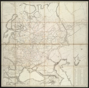
Carte de da partie européenne de l'empire de Russie : avec l'indication des chemins de poste, ainsi que des douanes...
13.
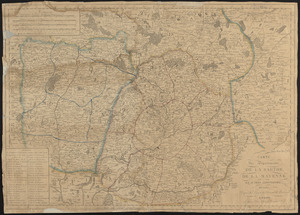
Carte des départements de La Sarthe, de La Mayenne et autres limitrophes, divisée d'apres les décrets de l'Assemblée Nationale
14.
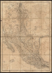
Carte générale du royaume de la Nouvelle Espagne depuis le parallèle de 16° jusqu'au parallèle de 38° (latitude nord)
15.
Carte routière des environs de Paris, divisés par departemens, arrondissemens communaux et cantons
16.
A chart of the gulf stream
17.
Charte von Italien : Nach seiner neuesten Eintheilung und den vorzüglichsten Hülfsmitteln
18.
Charte von Schweden und Norwegen
19.
Deutschland und der gröste theil der umliegenden staaten, oder Mittel-Europa in 35 blättern : nach astronomischen...
20.
Dongguk yojido
‹ Prev
Next ›
1
2
3


![Armstrong C[ount]y](https://bpldcassets.blob.core.windows.net/derivatives/images/commonwealth:q524ng353/image_thumbnail_300.jpg)