Toggle navigation
LMEC Home
Exhibitions
Georeferencing
Tools for Teachers
Collections
My Favorites
Sign Up / Log In
Search
Search the map portal
Map Collection
Map Collection
Map Sets
Search
Search
Search for
Search In
All Fields
Creator
Title
Subject
Place
Search All Digital Collections
Advanced Search
8 Results
My Search
Start Over
poland/
Remove constraint poland/
Date
1800
to
1849
Remove constraint Date: <span class='from'>1800</span> to <span class='to'>1849</span>
Filter your Search
Place
Europe
6
Poland
4
Germany
3
Asia
1
Austria
1
Belarus
1
Bohemia
1
Czech Republic
1
more
Place
»
Topic
Poland--Maps
4
Germany--Maps
3
Seven Years' War, 1756-1763--Campaigns--Poland
3
Austria--Maps
1
Belarus--Maps
1
Bohemia (Czech Republic)--Maps
1
Europe, Eastern--Maps
1
Kołobrzeg (Poland)--History--Siege, 1758
1
more
Topic
»
Date
1800
to
1849
[remove]
8
Date range begin
–
Date range end
Current results range from
1785
to
1818
1800
to
1804
4
1805
to
1809
4
1810
to
1814
4
1815
to
1819
5
1820
to
1824
0
1825
to
1829
0
1830
to
1834
0
1835
to
1839
0
1840
to
1844
0
1845
to
1849
0
Creator
Neele, Samuel John, 1758-1824
3
Barker, W. (William), active 1795-1803
1
Carey, Mathew, 1760-1839
1
Geographisches Institut (Weimar, Thuringia, Germany)
1
Lapie, M. (Pierre), 1779-1850
1
Russia. Depo kart
1
Sotzmann, -F.
1
Sotzmann, D. F.
1
more
Creator
»
Format
Maps/Atlases
8
Georeferenced
No
8
Collection
Norman B. Leventhal Map Center Collection
8
Available to use
No known restrictions
8
Search Constraints
Sort by relevance
relevance
title
date (asc)
date (desc)
Number of results to display per page
20 per page
10
per page
20
per page
50
per page
100
per page
View results as:
grid view
map view
Search Results
1.
Poland, shewing the claims of Russia, Prussia & Austria, until the late depredations, the extent of which cannot as yet be...
2.
Karta T︠sarstva Pol'skago sluzhashchai︠a︡ k prodolzhenīi︠u︡ podrobnoĭ karty Rossīi sochinena pri sobstvennom" Ego...
3.
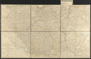
Charte von den Königreichen Preussen und Polen dem Grosherzogthum Posen nebst dem Gebiete der freien Stadt Krakau : nach dem...
4.
The siege of Colberg, from 3d. to 31st. October, 1758
5.
Cannonade at Pass Krug, 3d. October 1758
6.
Battle of Zorndorf
7.
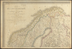
Carte de la Russie d'Europe, avec l'Empire d'Autriche, la Suede, le Danemark et la Norwege, la Prusse, le Grand Duche ́de...
8.
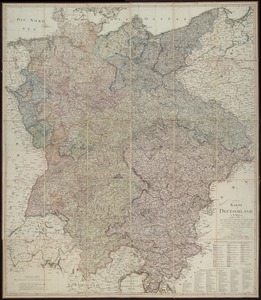
Karte von Deutschland : in IV Blättern entworfen im Jahre 1805, und nach den, durch die Bundesacte der Reinschen...