Toggle navigation
LMEC Home
Exhibitions
Georeferencing
Tools for Teachers
Collections
My Favorites
Sign Up / Log In
Search
Search the map portal
Map Collection
Map Collection
Map Sets
Search
Search
Search for
Search In
All Fields
Creator
Title
Subject
Place
Search All Digital Collections
Advanced Search
1 Results
My Search
Start Over
39999058991009
Remove constraint 39999058991009
Filter your Search
Place
Europe
1
France
1
Paris
1
Île-de-France
1
Topic
Paris (France)--Aerial views--Early works to 1800
1
Paris (France)--Maps--Early works to 1800
1
Date
1739
1
Creator
Aubin
1
Bretez, Louis, -1738
1
Lucas, Claude, active 18th century
1
Turgot, Michel-Etienne, 1690-1751
1
Format
Maps/Atlases
1
Georeferenced
No
1
Collection
Norman B. Leventhal Map & Education Center Collection
1
Urban Maps
1
Available to use
No known restrictions
1
Search Constraints
Search for
39999058991504
or
39999058996909
instead?
Sort by relevance
relevance
title
date (asc)
date (desc)
Number of results to display per page
20 per page
10
per page
20
per page
50
per page
100
per page
View results as:
grid view
map view
Search Results
1.
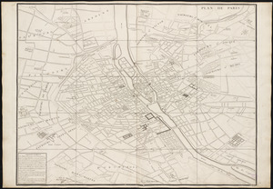
Plan de Paris : commencé l'année 1734