Toggle navigation
LMEC Home
Exhibitions
Georeferencing
Tools for Teachers
Collections
My Favorites
Sign Up / Log In
Search
Search the map portal
Map Collection
Map Collection
Map Sets
Search
Search
Search for
Search In
All Fields
Creator
Title
Subject
Place
Search All Digital Collections
Advanced Search
6 Results
My Search
Start Over
"G1015 .S64 1662"
Remove constraint "G1015 .S64 1662"
Filter your Search
Place
Africa
1
America
1
Asia
1
Bermuda
1
Europe
1
Mesoamerica
1
North America
1
North and Central America
1
more
Place
»
Topic
Africa--Maps--Early works to 1800
1
America--Maps--Early works to 1800
1
Asia--Maps--Early works to 1800
1
Bermuda Islands--Maps--Early works to 1800
1
Europe--Maps--Early works to 1800
1
Landowners--Bermuda Islands--Maps--Early works to 1800
1
North America--Maps--Early works to 1800
1
Real property--Bermuda Islands--Maps--Early works to 1800
1
more
Topic
»
Date
1662
6
Creator
Speed, John, 1552?-1629
6
Format
Maps/Atlases
6
Georeferenced
No
6
Collection
Norman B. Leventhal Map Center Collection
6
Available to use
No known restrictions
6
Search Constraints
Sort by date (asc)
relevance
title
date (asc)
date (desc)
Number of results to display per page
20 per page
10
per page
20
per page
50
per page
100
per page
View results as:
grid view
map view
Search Results
1.
Africæ, described, the manners of their habits and buildings, newly done into English
2.
America : with those known parts in that unknowne worlde both people and manner of buildings discribed and inlarged
3.
Asia : with the islands adioyning described, the atire of the people, & townes of importance, all of them newly augmented
4.
Europ, and the cheife cities contayned therin, described; with the habits of most kingdoms now in use
5.
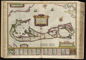
Mappa æstivarum insularum alias Bermudas dictarum, ad ostia Mexicani æstuary iacentium in latitudine graduum 32 minutorum 25 ab...
6.
A new and accurat map of the world : drawne according to ye truest descriptions latest discoveries & best observations yt have...