Toggle navigation
LMEC Home
Exhibitions
Georeferencing
Tools for Teachers
Collections
My Favorites
Sign Up / Log In
Search
Search the map portal
Map Collection
Map Collection
Map Sets
Search
Search
Search for
Search In
All Fields
Creator
Title
Subject
Place
Search All Digital Collections
Advanced Search
13385 Results
Filter your Search
Place
North and Central America
9,353
United States
7,078
Suffolk (county)
1,664
Boston
1,621
Europe
1,035
Canada
949
Massachusetts
794
New York
532
more
Place
»
Topic
Boston (Mass.)--Maps
741
City planning--Massachusetts--Boston--Maps
418
United States--History--Revolution, 1775-1783--Maps
329
United States--Maps
315
Urban renewal--Massachusetts--Boston--Maps
254
Real property--Massachusetts--Boston--Maps
252
Massachusetts--Maps
219
Insurance surveys
197
more
Topic
»
Date
Date range begin
–
Date range end
Current results range from
1482
to
2023
View distribution
Creator
United States. Hydrographic Office
595
Boston Redevelopment Authority
403
Des Barres, Joseph F. W. (Joseph Frederick Wallet), 1722-1824
247
Royal United Services Institute for Defence and Security Studies
160
Jefferys, Thomas, -1771
154
George, III, King of Great Britain, 1738-1820
152
George, IV, King of Great Britain, 1762-1830
151
O.H. Bailey & Co
148
more
Creator
»
Format
Maps/Atlases
13,205
Manuscripts
985
Prints
102
Books
49
Drawings/Illustrations
44
Photographs
15
Objects/Artifacts
13
Documents
7
more
Format
»
Georeferenced
Yes
979
No
12,406
Collection
Norman B. Leventhal Map Center Collection
8,891
American Revolutionary War-Era Maps
3,305
Boston and New England Maps
2,804
Urban Maps
2,397
Maritime Charts and Atlases
1,150
William L. Clements Library Collection
910
Library of Congress Collection
618
Boston Redevelopment Authority Collection
475
more
Collection
»
Available to use
No known restrictions
9,952
Creative Commons license
1,677
Search Constraints
Sort by relevance
relevance
title
date (asc)
date (desc)
Number of results to display per page
20 per page
10
per page
20
per page
50
per page
100
per page
View results as:
grid view
map view
Search Results
12461.
Topographical map of the seat of the war
12462.
Topographical map of the State of Massachusetts
12463.
A topographical map of the state of New Hampshire
12464.
A topographical map of the State of New Hampshire
12465.
Topographical map of the state of Rhode Island and Providence plantations
12466.
A topographical map of the state of Rhode-Island and Providence Plantations
12467.
A topographical map of the state of Vermont, : from actual survey. : Most humbly dedicated to His Excellency Thomas Chittenden...
12468.
A topographical map of the White Mountains, of New Hampshire
12469.
Topographical map of Virginia between Washington and Manassas Junction
12470.
Topographical map of West Roxbury park
12471.
Topographical map of Westmoreland and Albert Counties : from actual surveys by D.J. Lake and H.S. Peck
12472.
A topographical plan of modern Rome with the new additions
12473.
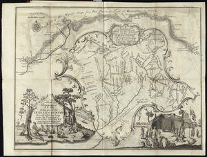
A topographical plan of that part of the Indian-country through which Colonel Bouquet marched in the year, 1764
12474.
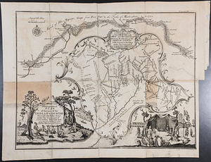
A topographical plan of that part of the Indian-country through which the army under the command of Colonel Bouquet marched in...
12475.
Topographical plan of the north shore of Lake Huron shewing recent surveys
12476.
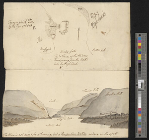
Topographical sketch of Lake George
12477.
Topographical sketch of the grounds of the State Insane Asylum, Danvers, Mass : Showing location of the buildings, roads, &c
12478.
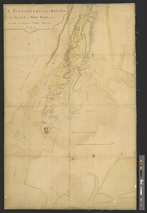
A topographical sketch of the island of New York, with part of the circumjacent country : November 1775
12479.
A topographicall description and admeasurement of the yland of Barbados in the West Indyaes : with the mrs. names of the...
12480.
Topographick plan by the eye, 1754 & 6
‹ Prev
Next ›
1
2
…
620
621
622
623
624
625
626
627
628
…
669
670