Toggle navigation
LMEC Home
Exhibitions
Georeferencing
Tools for Teachers
Collections
My Favorites
Sign Up / Log In
Search
Search the map portal
Map Collection
Map Collection
Map Sets
Search
Search
Search for
Search In
All Fields
Creator
Title
Subject
Place
Search All Digital Collections
Advanced Search
13385 Results
My Search
Start Over
Date facet yearly ssim
1800
to
1849
Remove constraint Date facet yearly ssim: <span class='from'>1800</span> to <span class='to'>1849</span>
Filter your Search
Place
North and Central America
10,111
United States
8,249
Massachusetts
2,691
Suffolk (county)
1,664
Boston
1,621
Europe
1,386
Canada
949
New York
640
more
Place
»
Topic
Boston (Mass.)--Maps
741
City planning--Massachusetts--Boston--Maps
418
United States--History--Revolution, 1775-1783--Maps
329
United States--Maps
315
Urban renewal--Massachusetts--Boston--Maps
254
Real property--Massachusetts--Boston--Maps
252
Massachusetts--Maps
219
Insurance surveys
197
more
Topic
»
Date
Date range begin
–
Date range end
Current results range from
1482
to
2023
View distribution
Creator
United States. Hydrographic Office
595
Boston Redevelopment Authority
403
Des Barres, Joseph F. W. (Joseph Frederick Wallet), 1722-1824
247
Royal United Services Institute for Defence and Security Studies
160
Jefferys, Thomas, -1771
154
George, III, King of Great Britain, 1738-1820
152
George, IV, King of Great Britain, 1762-1830
151
O.H. Bailey & Co
148
more
Creator
»
Format
Maps/Atlases
13,205
Manuscripts
985
Prints
102
Books
49
Drawings/Illustrations
44
Photographs
15
Objects/Artifacts
13
Documents
7
more
Format
»
Georeferenced
Yes
979
No
12,406
Collection
Norman B. Leventhal Map & Education Center Collection
8,891
American Revolutionary War-Era Maps
3,305
Boston and New England Maps
2,804
Urban Maps
2,397
Maritime Charts and Atlases
1,150
William L. Clements Library Collection
910
Library of Congress Collection
618
Boston Redevelopment Authority Collection
475
more
Collection
»
Available to use
No known restrictions
9,952
Creative Commons license
1,677
Search Constraints
Sort by relevance
relevance
title
date (asc)
date (desc)
Number of results to display per page
20 per page
10
per page
20
per page
50
per page
100
per page
View results as:
grid view
map view
Search Results
12001.
The State of New Hampshire
12002.
The state of New Hampshire
12003.
The state of New Hampshire : compiled chiefly from actual surveys
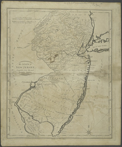
12004.
The State of New Jersey
12005.
The State of New Jersey : compiled from the most accurate surveys
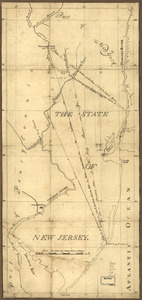
12006.
The State of New Jersey
12007.
The State of New Jersey : from original surveys based on the triangulation of the U.S. Coast and Geodetic Survey
12008.
The state of New Jersey : economic geology
12009.
The state of New Jersey, compiled from the most authentic information
12010.
State of New York
12011.
The state of New York
12012.
The state of New York, compiled from the best authorities
12013.
The state of New York, compiled from the most authentic information, 1796
12014.
The state of New York with part of the adjacent states
12015.
The state of North Carolina from the best authorities
12016.
The state of North Carolina from the best authorities, &c
12017.
State of North Dakota
12018.
State of North Dakota
12019.
State of Oaxaca
12020.
State of Ohio
‹ Prev
Next ›
1
2
…
597
598
599
600
601
602
603
604
605
…
669
670