Toggle navigation
LMEC Home
Exhibitions
Georeferencing
Tools for Teachers
Collections
My Favorites
Sign Up / Log In
Search
Search the map portal
Map Collection
Map Collection
Map Sets
Search
Search
Search for
Search In
All Fields
Creator
Title
Subject
Place
Search All Digital Collections
Advanced Search
13385 Results
Filter your Search
Place
North and Central America
10,111
United States
8,249
Massachusetts
2,691
Suffolk (county)
1,664
Boston
1,621
Europe
1,386
Canada
949
New York
640
more
Place
»
Topic
Boston (Mass.)--Maps
741
City planning--Massachusetts--Boston--Maps
418
United States--History--Revolution, 1775-1783--Maps
329
United States--Maps
315
Urban renewal--Massachusetts--Boston--Maps
254
Real property--Massachusetts--Boston--Maps
252
Massachusetts--Maps
219
Insurance surveys
197
more
Topic
»
Date
Date range begin
–
Date range end
Current results range from
1482
to
2023
View distribution
Creator
United States. Hydrographic Office
595
Boston Redevelopment Authority
403
Des Barres, Joseph F. W. (Joseph Frederick Wallet), 1722-1824
247
Royal United Services Institute for Defence and Security Studies
160
Jefferys, Thomas, -1771
154
George, III, King of Great Britain, 1738-1820
152
George, IV, King of Great Britain, 1762-1830
151
O.H. Bailey & Co
148
more
Creator
»
Format
Maps/Atlases
13,205
Manuscripts
985
Prints
102
Books
49
Drawings/Illustrations
44
Photographs
15
Objects/Artifacts
13
Documents
7
more
Format
»
Georeferenced
Yes
979
No
12,406
Collection
Norman B. Leventhal Map & Education Center Collection
8,891
American Revolutionary War-Era Maps
3,305
Boston and New England Maps
2,804
Urban Maps
2,397
Maritime Charts and Atlases
1,150
William L. Clements Library Collection
910
Library of Congress Collection
618
Boston Redevelopment Authority Collection
475
more
Collection
»
Available to use
No known restrictions
9,952
Creative Commons license
1,677
Search Constraints
Sort by relevance
relevance
title
date (asc)
date (desc)
Number of results to display per page
20 per page
10
per page
20
per page
50
per page
100
per page
View results as:
grid view
map view
Search Results
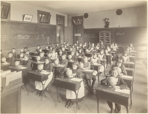
10861.
Putman School, 6th Grade
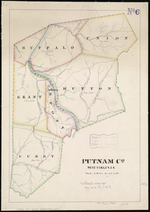
10862.
Putnam Co., West Virginia
10863.
Pvgna navalis in ipsis faucibus freti Öresund Svecos inter et Belgas Foederatos commissa d 29 Octob an: 1658
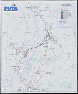
10864.
PVTA bus map & guide
10865.
P.W.A. and industry : how benefits are spread
10866.
P.W.A. in action
10867.
PWA rebuilds the nation
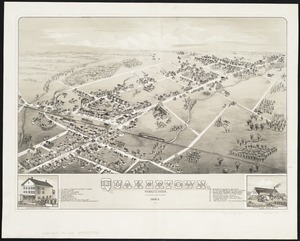
10868.
Quakertown : Pennsylvania
10869.
Quam hic vides orbis imagine[m] lector ca[n]dide ea[m] ut posteriore[m] ita & eme[n]datiorem ijs que hactenus...
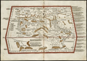
10870.
Quarta Africae tabula
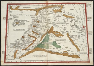
10871.
Quarta Asiae tabula
10872.
Quarta Asiae taubla continet Cyprum & Syrium & Iudea & vtraq. Arabia petream & deserta ac Mesopotamia & Babilonia
10873.
Quarta et Ultima Affrice tabula continet interiorem Libyã Ethyopiam q̄ sub Egypto ẽ & q̃ est interius cũ insulis ei...
10874.
Quarta Europae tabula
10875.
Quarta Europe tabula continet Germaniam
10876.
Quarte partie du monde
10877.
Quatre positions de la flotte française et positions de la flotte anglaise
10878.
Qubbec, ville de l'Amerique septentrionale dans la Nouvelle France avec titre d'Eveché située sur le fleuve de St. Laurens a...
10879.
Quebec
10880.
Queensland
‹ Prev
Next ›
1
2
…
540
541
542
543
544
545
546
547
548
…
669
670