Toggle navigation
LMEC Home
Exhibitions
Georeferencing
Tools for Teachers
Collections
My Favorites
Sign Up / Log In
Search
Search the map portal
Map Collection
Map Collection
Map Sets
Search
Search
Search for
Search In
All Fields
Creator
Title
Subject
Place
Search All Digital Collections
Advanced Search
154 Results
My Search
Start Over
vermont
Remove constraint vermont
Filter your Search
Place
North and Central America
150
United States
131
Vermont
95
New England
34
New York
23
New Hampshire
19
Massachusetts
13
Canada
9
more
Place
»
Topic
Vermont--Maps
30
New England--Maps
23
Railroads--New England--Maps
12
New Hampshire--Maps
11
Vermont--Maps--Early works to 1800
10
Long Trail (Vt.)--Maps
9
New York (State)--Maps
9
Trails--Vermont--Maps
9
more
Topic
»
Date
Date range begin
–
Date range end
Current results range from
1744
to
2015
View distribution
Creator
Burleigh, L. R., 1853-1923
13
Congdon, Herbert Wheaton, 1876-1965
9
Norris, George E.
7
United States. Post Office Dept
7
Faden, William, 1749-1836
5
Walling, Henry Francis, 1825-1888
5
Whitelaw, James, 1748-1829
5
Cram, George Franklin, 1841-1928
4
more
Creator
»
Format
Maps/Atlases
153
Manuscripts
13
Objects/Artifacts
1
Prints
1
Georeferenced
Yes
18
No
136
Collection
Norman B. Leventhal Map & Education Center Collection
112
Boston and New England Maps
78
American Revolutionary War-Era Maps
52
Urban Maps
25
William L. Clements Library Collection
7
American Antiquarian Society Collection
6
British Library Collection
5
Library of Congress Collection
5
more
Collection
»
Available to use
No known restrictions
114
Creative Commons license
18
Search Constraints
Sort by relevance
relevance
title
date (asc)
date (desc)
Number of results to display per page
20 per page
10
per page
20
per page
50
per page
100
per page
View results as:
grid view
map view
Search Results
81.
A map of the New England states : Maine, New Hampshire, Vermont, Massachusetts, Rhode Island & Connecticut, with the adjacent...
82.
A map of the New England states : Maine, New Hampshire, Vermont, Massachusetts, Rhode Island & Connecticut, with the adjacent...
83.
Post route map of the State of New York and parts of Vermont, Massachusetts, Connecticut, New Jersey, and Pennsylvania also the...
84.
Post route map of the State of New York and parts of Vermont, Massachusetts, Connecticut, New Jersey, and Pennsylvania also the...
85.
National map of New England states Vermont, New Hampshire, Massachusetts, Connecticut, Rhode Island and Maine showing counties...
86.
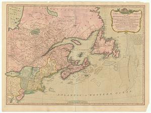
A new and correct map of the British colonies in North America : comprehending eastern Canada with the province of Quebec, New...
87.
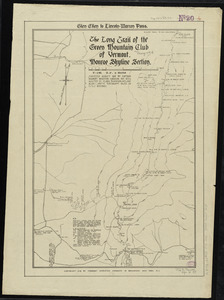
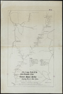
The Long Trail of the Green Mountain Club : Monroe Skyline Section : Bolton to Montclair Glen-Trails to Couching Lion
88.
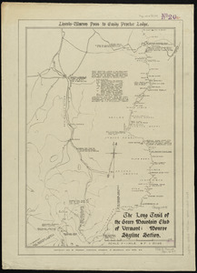
The Long Trail of the Green Mountain Club : Monroe Skyline Section : Lincoln-Warren Pass to Emily Proctor Lodge
89.
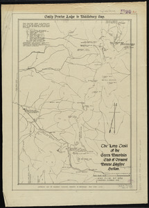
The Long Trail of the Green Mountain Club : Monroe Skyline Section : Emily Proctor Lodge to Middlebury Gap
90.
The Long Trail of the Green Mountain Club : Monroe Skyline Section : Glen Ellen to Lincoln-Warren Pass
91.
The Long Trail of the Green Mountain Club : Monroe Skyline Section : Couching Lion to Glen Ellen
92.
A map of New York showing counties, manors, townships, and estates, ca. 1778
93.
A map of New York showing counties, manors, townships, and estates, ca. 1778
94.
A map of the country in which the army under Lt. General Burgoyne acted in the campaign of 1777 : shewing the marches of the...
95.
The state of New York with part of the adjacent states
96.
Map of the rail road from Boston to Stanstead
97.
Map of the country copied from Hale's map of N. E. with railroad route from Boston to Lake Champlain : through Keene, N. H
98.
An accurate map of His Majesty's Province of New-Hampshire in New England & all the adjacent country northward to the River St....
99.
A map of the country in which the army under Lt. General Burgoyne acted in the campaign of 1777 : shewing the marches of the...
100.
A chorographical map of the northern department of North-America : drawn from the latest and most accurate observations
‹ Prev
Next ›
1
2
3
4
5
6
7
8