Toggle navigation
LMEC Home
Exhibitions
Georeferencing
Tools for Teachers
Collections
My Favorites
Sign Up / Log In
Search
Search the map portal
Map Collection
Map Collection
Map Sets
Search
Search
Search for
Search In
All Fields
Creator
Title
Subject
Place
Search All Digital Collections
Advanced Search
13385 Results
Filter your Search
Place
North and Central America
9,353
United States
7,078
Suffolk (county)
1,664
Boston
1,621
Europe
1,035
Canada
949
Massachusetts
794
New York
532
more
Place
»
Topic
Boston (Mass.)--Maps
741
City planning--Massachusetts--Boston--Maps
418
United States--History--Revolution, 1775-1783--Maps
329
United States--Maps
315
Urban renewal--Massachusetts--Boston--Maps
254
Real property--Massachusetts--Boston--Maps
252
Massachusetts--Maps
219
Insurance surveys
197
more
Topic
»
Date
Date range begin
–
Date range end
Current results range from
1482
to
2023
View distribution
Creator
United States. Hydrographic Office
595
Boston Redevelopment Authority
403
Des Barres, Joseph F. W. (Joseph Frederick Wallet), 1722-1824
247
Royal United Services Institute for Defence and Security Studies
160
Jefferys, Thomas, -1771
154
George, III, King of Great Britain, 1738-1820
152
George, IV, King of Great Britain, 1762-1830
151
O.H. Bailey & Co
148
more
Creator
»
Format
Maps/Atlases
13,205
Manuscripts
985
Prints
102
Books
49
Drawings/Illustrations
44
Photographs
15
Objects/Artifacts
13
Documents
7
more
Format
»
Georeferenced
Yes
979
No
12,406
Collection
Norman B. Leventhal Map Center Collection
8,891
American Revolutionary War-Era Maps
3,305
Boston and New England Maps
2,804
Urban Maps
2,397
Maritime Charts and Atlases
1,150
William L. Clements Library Collection
910
Library of Congress Collection
618
Boston Redevelopment Authority Collection
475
more
Collection
»
Available to use
No known restrictions
9,952
Creative Commons license
1,677
Search Constraints
Sort by relevance
relevance
title
date (asc)
date (desc)
Number of results to display per page
20 per page
10
per page
20
per page
50
per page
100
per page
View results as:
grid view
map view
Search Results
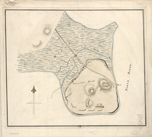
9341.
Plan of Paulus's Hook and fortifications
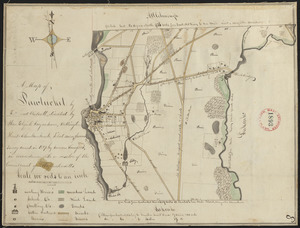
9342.
Plan of Pawtucket made by Edward Wolcott, dated 1827
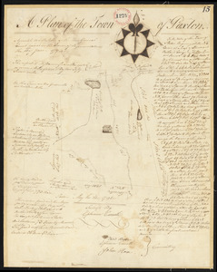
9343.
Plan of Paxton surveyed by Ephraim Carruth, dated May 23, 1795.
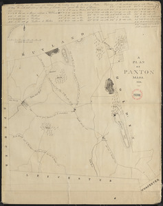
9344.
Plan of Paxton, surveyor's name not given, dated 1830
9345.
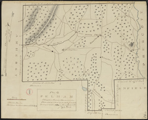
Plan of Pelham made by Cook, Zeba, and John Parmenter, dated October, 1830
9346.
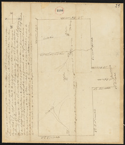
Plan of Pelham, surveyors' name not given, dated 1795.
9347.
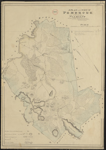
Plan of Pembroke made by John G. Hales, dated 1831
9348.
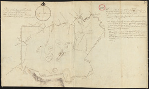
Plan of Pembroke, surveyor's name not given, dated 1794-5.
9349.
Plan of Penobscot surveyed by John Peters, dated 1794.
9350.
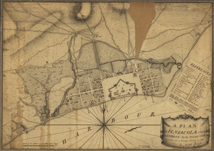
A plan of Pensacola and its environs in its present state : from an actual survey in 1778
9351.
Plan of Pepperell made by Caleb Butler, dated 1830
9352.
Plan of Pepperellborough (Saco) surveyed by Daniel Grainger, dated 1794.
9353.
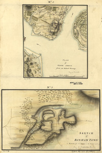
Plan of Perth Amboy from an actual survey. Sketch of Bonham Town
9354.
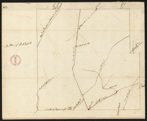
Plan of Peru (Partridgefield), surveyor's name not given, dated 1794-5.
9355.
Plan of Peru, surveyor's name not given, dated January 4, 1831
9356.
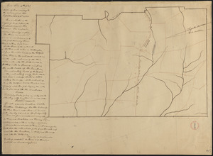
Plan of Petersham made by David Lee and Samuel Lee, dated November 30, 1830
9357.
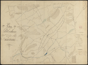
Plan of Petersham made by Jeremiah Robinson, dated May 1795.
9358.
Plan of Phillipston made by Jason Lamb, dated November 1830
9359.
A Plan of Pitts Fort at Pittsburgh. Oct.r 1759
9360.
Plan of Pittsfield, surveyor's name not given, dated 1831
‹ Prev
Next ›
1
2
…
464
465
466
467
468
469
470
471
472
…
669
670