Toggle navigation
LMEC Home
Exhibitions
Georeferencing
Tools for Teachers
Collections
My Favorites
Sign Up / Log In
Search
Search the map portal
Map Collection
Map Collection
Map Sets
Search
Search
Search for
Search In
All Fields
Creator
Title
Subject
Place
Search All Digital Collections
Advanced Search
14021 Results
Filter your Search
Place
North and Central America
10,683
United States
8,692
Massachusetts
2,808
Suffolk (county)
1,682
Boston
1,638
Europe
1,420
Canada
1,009
New York
674
more
Place
»
Topic
Boston (Mass.)--Maps
748
City planning--Massachusetts--Boston--Maps
418
United States--History--Revolution, 1775-1783--Maps
331
United States--Maps
328
Real property--Massachusetts--Boston--Maps
254
Urban renewal--Massachusetts--Boston--Maps
254
North America--Maps--Early works to 1800
240
Massachusetts--Maps
234
more
Topic
»
Date
Date range begin
–
Date range end
Current results range from
1482
to
2023
View distribution
Creator
United States. Hydrographic Office
597
Boston Redevelopment Authority
404
Des Barres, Joseph F. W. (Joseph Frederick Wallet), 1722-1824
247
Jefferys, Thomas, -1771
172
Royal United Services Institute for Defence and Security Studies
160
George, III, King of Great Britain, 1738-1820
152
George, IV, King of Great Britain, 1762-1830
151
O.H. Bailey & Co
148
more
Creator
»
Format
Maps/Atlases
13,839
Manuscripts
985
Prints
102
Books
49
Drawings/Illustrations
44
Photographs
15
Objects/Artifacts
13
Documents
7
more
Format
»
Georeferenced
Yes
979
No
13,042
Collection
Norman B. Leventhal Map & Education Center Collection
9,110
American Revolutionary War-Era Maps
3,627
Boston and New England Maps
2,921
Urban Maps
2,480
Maritime Charts and Atlases
1,169
William L. Clements Library Collection
910
Library of Congress Collection
618
Boston Redevelopment Authority Collection
475
more
Collection
»
Available to use
No known restrictions
10,268
Creative Commons license
1,678
Search Constraints
Sort by relevance
relevance
title
date (asc)
date (desc)
Number of results to display per page
20 per page
10
per page
20
per page
50
per page
100
per page
View results as:
grid view
map view
Search Results
9061.
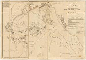
A plan of Boston, and its environs : shewing the true situation of His Majesty's army, and also those of the rebels
9062.
A plan of Boston, and its environs : shewing the true situation of His Majesty's army, and also those of the rebels
9063.
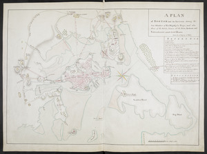
A PLAN of BOSTON and its Environs shewing the true Situation of His Majesty's Troops, and also those of the Rebels; likewise...
9064.
Plan of Boston and its vicinity
9065.
Plan of Boston and its vicinity
9066.
Plan of Boston and its vicinity
9067.
Plan of Boston and its vicinity showing the connection of the Grand Junction Rail Road with the Harbor and other Rail-roads
9068.
Plan of Boston and its vicinity, showing the drainage area of Stony Brook which empties into the full basin of the Back Bay
9069.
Plan of Boston and its vicinity, showing the drainage area of Stony Brook which empties into the full basin of the Back Bay
9070.
Plan of Boston and Roxbury
9071.
Plan of Boston comprising a part of Charlestown and Cambridge
9072.
Plan of Boston comprising a part of Charlestown and Cambridge
9073.
Plan of Boston comprising a part of Charlestown and Cambridge
9074.
Plan of Boston comprising a part of Charlestown and Cambridge
9075.
Plan of Boston comprising a part of Charlestown and Cambridge
9076.
Plan of Boston comprising a part of Charlestown and Cambridge
9077.
Plan of Boston comprising a part of Charlestown and Cambridge
9078.
Plan of Boston comprising a part of Charlestown and Cambridge
9079.
Plan of Boston Corner made by Augustus Tremain, dated June 7, 1840
9080.
A plan of Boston, from actual survey
‹ Prev
Next ›
1
2
…
450
451
452
453
454
455
456
457
458
…
701
702