Toggle navigation
LMEC Home
Exhibitions
Georeferencing
Tools for Teachers
Collections
My Favorites
Sign Up / Log In
Search
Search the map portal
Map Collection
Map Collection
Map Sets
Search
Search
Search for
Search In
All Fields
Creator
Title
Subject
Place
Search All Digital Collections
Advanced Search
13518 Results
My Search
Start Over
Date facet yearly ssim
1829
Remove constraint Date facet yearly ssim: <span class='single'>1829</span>
Filter your Search
Place
North and Central America
10,232
United States
8,367
Massachusetts
2,778
Suffolk (county)
1,675
Boston
1,631
Europe
1,386
Canada
949
New York
640
more
Place
»
Topic
Boston (Mass.)--Maps
746
City planning--Massachusetts--Boston--Maps
418
United States--History--Revolution, 1775-1783--Maps
329
United States--Maps
321
Real property--Massachusetts--Boston--Maps
254
Urban renewal--Massachusetts--Boston--Maps
254
Massachusetts--Maps
230
Insurance surveys
197
more
Topic
»
Date
Date range begin
–
Date range end
Current results range from
1482
to
2023
View distribution
Creator
United States. Hydrographic Office
596
Boston Redevelopment Authority
404
Des Barres, Joseph F. W. (Joseph Frederick Wallet), 1722-1824
247
Royal United Services Institute for Defence and Security Studies
160
Jefferys, Thomas, -1771
154
George, III, King of Great Britain, 1738-1820
152
George, IV, King of Great Britain, 1762-1830
151
O.H. Bailey & Co
148
more
Creator
»
Format
Maps/Atlases
13,337
Manuscripts
985
Prints
102
Books
49
Drawings/Illustrations
44
Photographs
15
Objects/Artifacts
13
Documents
7
more
Format
»
Georeferenced
Yes
979
No
12,539
Collection
Norman B. Leventhal Map & Education Center Collection
9,022
American Revolutionary War-Era Maps
3,305
Boston and New England Maps
2,900
Urban Maps
2,425
Maritime Charts and Atlases
1,167
William L. Clements Library Collection
910
Library of Congress Collection
618
Boston Redevelopment Authority Collection
475
more
Collection
»
Available to use
No known restrictions
10,085
Creative Commons license
1,677
Search Constraints
Sort by relevance
relevance
title
date (asc)
date (desc)
Number of results to display per page
20 per page
10
per page
20
per page
50
per page
100
per page
View results as:
grid view
map view
Search Results
8581.
Plan of Attleborough, surveyor's name not given, dated May, 1795.
8582.
Plan of Back Bay and vicinity : prepared from surveys made under the direction of Simon Greenleaf, Joel Giles, Ezra Lincoln,...
8583.
Plan of Back Bay showing improvements on streets and estates
8584.
Plan of Bahía Honda ; Plan of Puerto de Cavañas
8585.
Plan of Bahia Xagua on the south side of Cuba ; Plan of the Colorado Rocks, near the west end of Cuba
8586.
Plan of Ballstown (Jefferson and Whitefield) surveyed by William Davis, dated May 20, 1795.
8587.
Plan of Bangor made by Elihu Warner, dated October 20, 1795.
8588.
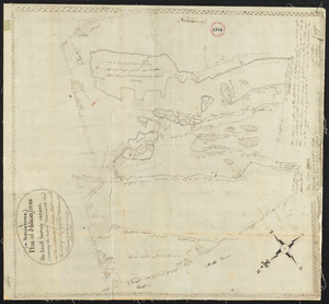
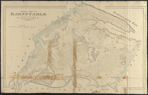
Plan of Barnstable made by John G. Hales, dated 1831
8589.
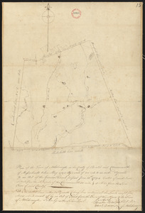
Plan of Barnstable surveyed by Samuel Basset, dated May, 1795.
8590.
Plan of Barre made by David Lee and Samuel Lee, dated June 1830
8591.
Plan of Barre surveyor's name not given, dated December, 1794.
8592.
Plan of Bath, Me, made by Dummer Sewall, dated March 7, 1795.
8593.
Plan of Becket made by Luke Barber, dated October 26, 1831
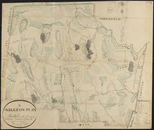
8594.
A plan of Becket protracted by a scale of 120 rods to an inch
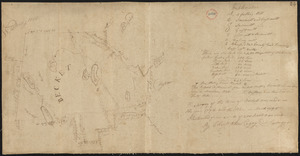
8595.
Plan of Becket surveyed by Christopher Crary, dated March, 1795.
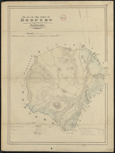
8596.
Plan of Bedford made by John G. Hales, dated 1830
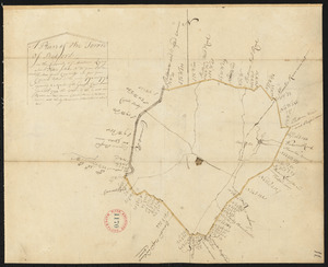
8597.
Plan of Bedford, surveyor's name not given, dated 1794-5.
8598.
Plan of Belchertown made by Elias Bassett, dated November, 1830
8599.
Plan of Belchertown, surveyor's name not given, dated December, 1794.
8600.
Plan of Belfast surveyed by Alexander Clark, dated 1794.
‹ Prev
Next ›
1
2
…
426
427
428
429
430
431
432
433
434
…
675
676