Toggle navigation
LMEC Home
Exhibitions
Georeferencing
Tools for Teachers
Collections
My Favorites
Sign Up / Log In
Search
Search the map portal
Map Collection
Map Collection
Map Sets
Search
Search
Search for
Search In
All Fields
Creator
Title
Subject
Place
Search All Digital Collections
Advanced Search
13518 Results
My Search
Start Over
Date facet yearly ssim
1550
to
1599
Remove constraint Date facet yearly ssim: <span class='from'>1550</span> to <span class='to'>1599</span>
Filter your Search
Place
North and Central America
10,232
United States
8,367
Massachusetts
2,778
Suffolk (county)
1,675
Boston
1,631
Europe
1,386
Canada
949
New York
640
more
Place
»
Topic
Boston (Mass.)--Maps
746
City planning--Massachusetts--Boston--Maps
418
United States--History--Revolution, 1775-1783--Maps
329
United States--Maps
321
Real property--Massachusetts--Boston--Maps
254
Urban renewal--Massachusetts--Boston--Maps
254
Massachusetts--Maps
230
Insurance surveys
197
more
Topic
»
Date
Date range begin
–
Date range end
Current results range from
1482
to
2023
View distribution
Creator
United States. Hydrographic Office
596
Boston Redevelopment Authority
404
Des Barres, Joseph F. W. (Joseph Frederick Wallet), 1722-1824
247
Royal United Services Institute for Defence and Security Studies
160
Jefferys, Thomas, -1771
154
George, III, King of Great Britain, 1738-1820
152
George, IV, King of Great Britain, 1762-1830
151
O.H. Bailey & Co
148
more
Creator
»
Format
Maps/Atlases
13,337
Manuscripts
985
Prints
102
Books
49
Drawings/Illustrations
44
Photographs
15
Objects/Artifacts
13
Documents
7
more
Format
»
Georeferenced
Yes
979
No
12,539
Collection
Norman B. Leventhal Map & Education Center Collection
9,022
American Revolutionary War-Era Maps
3,305
Boston and New England Maps
2,900
Urban Maps
2,425
Maritime Charts and Atlases
1,167
William L. Clements Library Collection
910
Library of Congress Collection
618
Boston Redevelopment Authority Collection
475
more
Collection
»
Available to use
No known restrictions
10,085
Creative Commons license
1,677
Search Constraints
Sort by relevance
relevance
title
date (asc)
date (desc)
Number of results to display per page
20 per page
10
per page
20
per page
50
per page
100
per page
View results as:
grid view
map view
Search Results
8281.
Plan and section, Mooseland gold district, Halifax co., N.S
8282.
Plan and section, Mount Uniacke gold district, Hants Co., Nova Scotia
8283.
A plan and section of the two routs in Woburn, say 1795 : Middlesex Canal
8284.
Plan and section, Salmon River gold district, Halifax Co., N.S
8285.
Plan and section, South Uniacke gold district, Hants and Halifax Counties, Nova Scotia
8286.
Plan and section, Tangier gold district, Halifax Co., Nova Scotia
8287.
Plan and sections, Brookfield gold district, Queens Co., Nova Scotia
8288.
Plan and sections, Caribou gold district, Halifax Co., N.S
8289.
Plan and sections Harrigan Cove gold district, Halifax Co., Nova Scotia
8290.
Plan and sections Isaacs Harbour gold district, Guysborough Co., Nova Scotia
8291.
Plan and sections Malaga gold district, Queens Co., Nova-Scotia
8292.
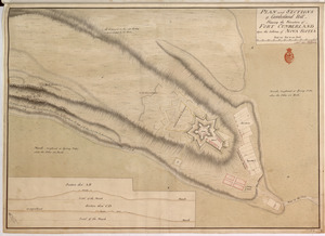
PLAN and SECTIONS of Cumberland Hill Showing the Situation of FORT CUMBERLAND Upon the Isthmus of NOVA SCOTIA
8293.
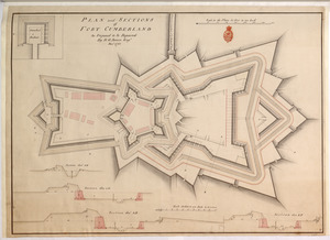
PLAN and SECTIONS of FORT CUMBERLAND As Proposed to be Repaired
8294.
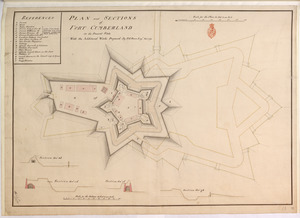
PLAN and SECTIONS of FORT CUMBERLAND in its Present State With the Additional Works Proposed
8295.
Plan and sections of Fort Fisher, carried by assault by the U.S. forces, Maj. Gen. A.H. Terry commanding, Jan. 15th, 1865
8296.
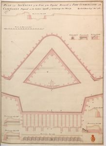
PLAN and SECTIONS of the Front of the Projected Hornwork at FORT CUMBERLAND with CASEMATES Proposed in the Curtain Capable of...
8297.
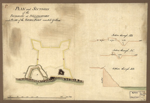
Plan and sections of the redoubt at Billingsfort and plan of the rebel fort marked yellow
8298.
Plan and sections, Oldham gold district, Halifax Co., N.S
8299.
Plan and sections Renerew gold district, Hants Co. Nova Scotia
8300.
Plan and sections Upper Seal Harbour, Guysborough Co., N.S
‹ Prev
Next ›
1
2
…
411
412
413
414
415
416
417
418
419
…
675
676