Toggle navigation
LMEC Home
Exhibitions
Georeferencing
Tools for Teachers
Collections
My Favorites
Sign Up / Log In
Search
Search the map portal
Map Collection
Map Collection
Map Sets
Search
Search
Search for
Search In
All Fields
Creator
Title
Subject
Place
Search All Digital Collections
Advanced Search
89 Results
My Search
Start Over
Date
1904
Remove constraint Date: <span class='single'>1904</span>
Filter your Search
Place
North and Central America
63
United States
50
Massachusetts
18
Asia
11
Boston
11
Suffolk (county)
11
Canada
9
China
6
more
Place
»
Topic
Boston (Mass.)--Maps
7
United States--Maps
6
Gold mines and mining--Nova Scotia--Maps
5
Korea--Maps
5
Manchuria (China)--Maps
4
Canada--Maps
3
New England--Maps--Early works to 1800--Facsimiles
3
Real property--Massachusetts--Boston--Maps
3
more
Topic
»
Date
1904
[remove]
89
Date range begin
–
Date range end
Current results range from
1770
to
1999
1904
to
1904
89
Creator
Geo. H. Walker & Co.
8
Geological Survey of Canada
5
Fisk, E. F.
3
Geological Survey (U.S.)
3
Barnes & Farnham
2
Blanchard, Rufus, 1821-1904
2
Boston Elevated Railway Company
2
Bromley, George Washington
2
more
Creator
»
Format
Maps/Atlases
87
Books
1
Photographs
1
Prints
1
Georeferenced
Yes
12
No
77
Collection
Norman B. Leventhal Map & Education Center Collection
80
Boston and New England Maps
7
Urban Maps
5
Massachusetts Real Estate Atlases
4
Robert E. Diefenbach Map Collection at Phillips Academy
3
American Revolutionary War-Era Maps
1
American Textile History Museum Image Collection
1
Maritime Charts and Atlases
1
more
Collection
»
Available to use
No known restrictions
83
Search Constraints
Sort by relevance
relevance
title
date (asc)
date (desc)
Number of results to display per page
20 per page
10
per page
20
per page
50
per page
100
per page
View results as:
grid view
map view
Search Results
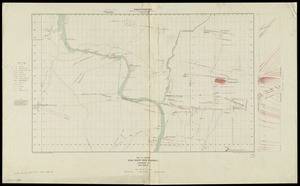
61.
Plan and section, Gold River gold district, Lunenburg Co., Nova Scotia
62.
Plan and section, Salmon River gold district, Halifax Co., N.S
63.
Plan and sections, Caribou gold district, Halifax Co., N.S
64.
Plan and sections Isaacs Harbour gold district, Guysborough Co., Nova Scotia
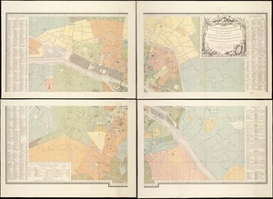
65.
Plan des paroisses de Paris : avec la distinction des parties eparses qui de dépendent
66.
Plan of corner of Centry & Beacon St's -- 1741
67.
Plan of the burnt district : showing proposed improvements in streets. Nov. 12th 1872
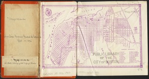
68.
Plan of the town of Boston
69.
Plano de Asuncion
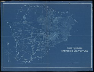
70.
Plano topografico del canton de Los Tuxtlas
71.
The public libraries of Massachusetts
72.
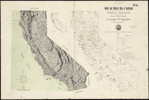
Relief and mineral map of California showing the topography and the approximate locations of all the principal mineral deposits...
73.
Relief map of the Dominion of Canada
74.
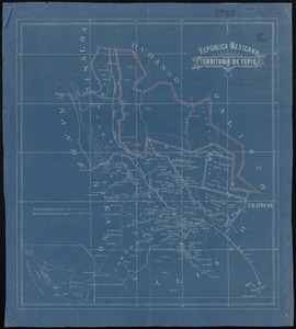
República Mexicana, Territorio de Tepic
75.
Samuel Thaxter & Son, manufacturers and importers of nautical and optical instruments, charts and nautical books; publishers of...
76.
Scarborough's new county and post office map of Louisiana and Mississippi : with complete index giving population and location...
77.
A small map of the sea coast of New England together with the outlines of several of the provinces lying thereon, 1738
78.
South Manchuria
79.
The south part of New-England, as it is planted this yeare, 1635
80.
Standard Russo-Japanese war map July 1904
‹ Prev
Next ›
1
2
3
4
5