Toggle navigation
LMEC Home
Exhibitions
Georeferencing
Tools for Teachers
Collections
My Favorites
Sign Up / Log In
Search
Search the map portal
Map Collection
Map Collection
Map Sets
Search
Search
Search for
Search In
All Fields
Creator
Title
Subject
Place
Search All Digital Collections
Advanced Search
82 Results
My Search
Start Over
Date
1835
Remove constraint Date: <span class='single'>1835</span>
Filter your Search
Place
North and Central America
52
United States
42
Massachusetts
18
Boston
12
Europe
12
Suffolk (county)
12
Ohio
5
Michigan
4
more
Place
»
Topic
Boston (Mass.)--Maps
9
Ohio--Boundaries--Michigan--Maps
6
Michigan--Boundaries--Ohio--Maps
5
Korea--Maps
4
China--Maps
3
Japan--Maps
3
Maryland--Maps
3
Rome (Italy)--Maps
3
more
Topic
»
Date
1835
[remove]
82
Date range begin
–
Date range end
Current results range from
1770
to
1990
1835
to
1835
82
Creator
Bradford, T. G. (Thomas Gamaliel), 1802-1887
4
Fuller, Stephen P.
3
Bonner, John, ca. 1643-1726
2
Hood, Washington
2
Hood, Washington.
2
Pendleton's Lithography
2
Talcott, Andrew, 1797-1883
2
United States. Army. Corps of Engineers
2
more
Creator
»
Format
Maps/Atlases
80
Manuscripts
12
Drawings/Illustrations
1
Objects/Artifacts
1
Prints
1
Georeferenced
Yes
9
No
73
Collection
Norman B. Leventhal Map & Education Center Collection
64
Urban Maps
17
Boston and New England Maps
15
American Revolutionary War-Era Maps
12
Library of Congress Collection
5
MacLean Collection Map Library
4
Sidney R. Knafel Map Collection at Phillips Academy
3
Newberry Library Collection
2
more
Collection
»
Available to use
No known restrictions
66
Creative Commons license
6
Search Constraints
Sort by relevance
relevance
title
date (asc)
date (desc)
Number of results to display per page
20 per page
10
per page
20
per page
50
per page
100
per page
View results as:
grid view
map view
Search Results
41.
Massachusetts
42.
National map of the United States
43.
Northern Africa
44.
Ohio boundary no. 1 South Bend of Lake Michigan : map, exhibiting the position occupied in the determination of the latitude of...
45.
Ohio boundary no. 1 South Bend of Lake Michigan : map, exhibiting the position occupied in the determination of the latitude of...
46.
Ohio boundary no. 2 : map exhibiting the positions occupied on the Maumee Bay and river: viz: Turtle Island, the North Cape,...
47.
Palestine or Canaan
48.
Physical map of Germany
49.
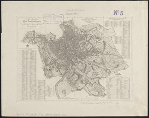
Pianta di Roma
50.
Pianta di Roma
51.
[Plan de defense de New-Port] : [dans l'Isle Rhode (Amerique Septentrionalle) par l'escadre du Roy aux ordres de Monsieur le...
52.
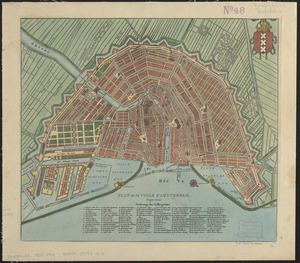
Plan de la ville d'Amsterdam
53.
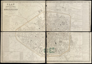
Plan géométrique de la ville de Bruxelles
54.
A plan of Boston, from actual survey by Osgood Carleton
55.
Plan of Boston with parts of the adjacent towns
56.
Plan of Boston with parts of the adjacent towns
57.
Plan of building lots on Phillips Place, Tremont & Somerset Streets
58.
Plan of building lots on Phillips Place, Tremont & Somerset Streets
59.
Plan of Dean Danl Greens farm in Reading
60.
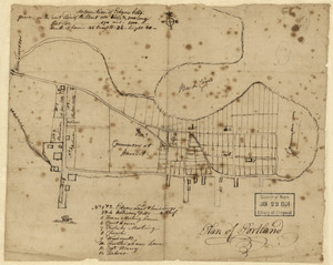
Plan of Portland
‹ Prev
Next ›
1
2
3
4
5


![[Plan de defense de New-Port]](https://bpldcassets.blob.core.windows.net/derivatives/images/commonwealth:z603vn044/image_thumbnail_300.jpg)