Toggle navigation
LMEC Home
Exhibitions
Georeferencing
Tools for Teachers
Collections
My Favorites
Sign Up / Log In
Search
Search the map portal
Map Collection
Map Collection
Map Sets
Search
Search
Search for
Search In
All Fields
Creator
Title
Subject
Place
Search All Digital Collections
Advanced Search
116 Results
My Search
Start Over
Date
1848
Remove constraint Date: <span class='single'>1848</span>
Filter your Search
Place
North and Central America
52
United States
42
Oceania
32
Massachusetts
18
Europe
12
French Polynesia
9
Boston
8
Fiji
8
more
Place
»
Topic
United States Exploring Expedition (1838-1842)
16
Tuamotu Archipelago (French Polynesia)--Maps
6
China--Maps
5
Boston (Mass.)--Maps
4
Korea--Maps
4
Massachusetts--Maps
3
Nautical charts--Fiji--Vanua Levu
3
New England--Maps
3
more
Topic
»
Date
1848
[remove]
116
Date range begin
–
Date range end
Current results range from
1770
to
1990
1848
to
1848
116
Creator
United States Exploring Expedition (1838-1842)
34
Wilkes, Charles, 1798-1877
31
Sherman & Smith
19
Boynton, George W., -1884
3
Knight, J. (Engraver)
3
Bouvé, Ephraim W., 1817-1897
2
Collinson, Richard, Sir, 1811-1883
2
Copley, Charles
2
more
Creator
»
Format
Maps/Atlases
115
Manuscripts
13
Books
1
Georeferenced
Yes
12
No
104
Collection
Norman B. Leventhal Map & Education Center Collection
98
Maritime Charts and Atlases
39
Boston and New England Maps
17
Urban Maps
14
American Revolutionary War-Era Maps
12
Library of Congress Collection
5
MacLean Collection Map Library
4
Newberry Library Collection
2
more
Collection
»
Available to use
No known restrictions
101
Creative Commons license
6
Search Constraints
Sort by relevance
relevance
title
date (asc)
date (desc)
Number of results to display per page
20 per page
10
per page
20
per page
50
per page
100
per page
View results as:
grid view
map view
Search Results
21.
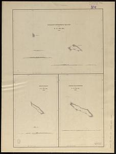
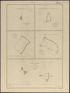
Disappointment Group ; Serle Island ; Clermont-Tonnere
22.
Dongguk yojido
23.
Eastern passages to China
24.
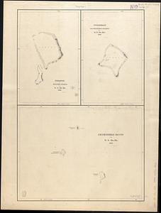
Fakaafo or Bowditch Island ; Nuku-Nono or Duke of Clarence Island ; Oatáfu or Duke of York Island
25.
Fangaloa Bay, north side of Upolu
26.
Funafuti or Ellices Island ; Nukufetau or De Peysters Island ; De Peysters Group
27.
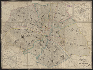
Galignani's plan of Paris and environs
28.
Geographisches lottospiel, ganz neue vermehrte u. verbesserte auflage : durch welches sich die kinder spielend neit den...
29.
Geological map of part of Jamaica
30.
Haejwa do
31.
Harbour of Mataatu, north side, island of Savaii ; Harbour of Apia, north side, island of Upolu ; roadstead between Laulii and...
32.
Harbour of Pago Pago, island of Tutuila
33.
Harbour of Sanaapu, island of Upolu ; Harbour of Falifa, island of Upolu
34.
Harbour of Uafato, island of Upolu ; Harbour of Saluafata, island of Upolu
35.
Harbours of Papieti, Toanoa, Papaoa and Matavai Bay, with the ship channel through reef, island of Tahiti
36.
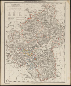
Hohenzollern-Hechingen und Sigmaringen
37.
Hudsons Island ; Maraki or Matthews Island, Kingsmill Group ; Maiana or Halls Island, Kingsmill Group ; Apamama or Hoppers...
38.
Island and harbours of Mbenga, south side of Viti Levu, Feejee Group ; Rewa-Roads, south side of Viti Levu
39.
Island of Moala, Feejee Group ; Island of Totoia, Feejee Group ; Island of Matuku, Feejee Group
40.
Island of Ovolau, Feejee Group
‹ Prev
Next ›
1
2
3
4
5
6