Toggle navigation
LMEC Home
Exhibitions
Georeferencing
Tools for Teachers
Collections
My Favorites
Sign Up / Log In
Search
Search the map portal
Map Collection
Map Collection
Map Sets
Search
Search
Search for
Search In
All Fields
Creator
Title
Subject
Place
Search All Digital Collections
Advanced Search
36 Results
My Search
Start Over
Date
1736
Remove constraint Date: <span class='single'>1736</span>
Filter your Search
Place
North and Central America
15
United States
7
Europe
6
Africa
5
New York
4
Asia
3
France
3
Kyoto
3
more
Place
»
Topic
World maps--Early works to 1800
3
Africa, North--Maps--Early works to 1800
2
Kyoto (Japan)--Maps
2
North America--Maps--Early works to 1800
2
1732
1
Africa, Southern--Maps--Early works to 1800
1
Africa--Maps--Early works to 1800
1
Annapolis Basin (N.S.)--Maps--Early works to 1800
1
more
Topic
»
Date
1736
[remove]
36
Date range begin
–
Date range end
Current results range from
1699
to
1800
1736
to
1736
36
Creator
Moll, Herman, d. 1732
10
Nolin, Jean Baptiste, 1686-1762
3
Bowles, John, 1701-1779
2
Bowles, Thomas, 1694-1773
2
Burghers, M.
2
Hayashi, Yoshinaga
2
Amherst, Jeffery Amherst, Baron, 1717-1797
1
Blackmore, Nathaniel.
1
more
Creator
»
Format
Maps/Atlases
36
Manuscripts
2
Georeferenced
Yes
2
No
34
Collection
Norman B. Leventhal Map & Education Center Collection
23
American Revolutionary War-Era Maps
9
William L. Clements Library Collection
7
MacLean Collection Map Library
3
British Library Collection
1
Library of Congress Collection
1
Maritime Charts and Atlases
1
Ralph Finos Map Collection at Phillips Academy
1
Available to use
No known restrictions
24
Creative Commons license
2
Search Constraints
Sort by relevance
relevance
title
date (asc)
date (desc)
Number of results to display per page
20 per page
10
per page
20
per page
50
per page
100
per page
View results as:
grid view
map view
Search Results
21.
Part of modern Orange County
22.
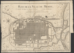
Plan de la ville de Meaco
23.
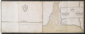
Plan du fort de Chouéghen de la Riviere Et de terrain aux Environs au Sud du Lac Ontario
24.
A pocket companion of Ireland : containing all the cities, market towns, boroughs, all ye great roads, and principal cross...
25.
River valley with several foothills and swamp
26.
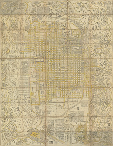
Shinsen zouho Kyo oezu
27.
Shinsen zouho Kyo oezu
28.
The south part of Africa, and the island of Madagascar : here the Portugueze have many settlements and all the trade
29.
St. Helena : this island belongs to ye English east India Company whose ships usually touch here for a recruit of fresh water...
30.
Totius Americae descriptio nova
31.
A tract of land granted to George Murray and Jacobas Bruyn lying & being in the county of Ulster on the west side of the Wall...
32.
Triangles on Mercator projection between St. Augustine and Cape Breton and St. Augustine and Cape Ortegal
33.
A view of the castle of Belem and the city of Lisbon as it appears from thence ; A map of the mouth of the famous river Tagus...
34.
Virginia Marylandia et Carolina in America septentrionali Brittannorum industria excultæ
35.
The west part of Barbary containing Fez, Marocco, Algiers and Tunis / : The east part of Barbary containing Tripoli, Barca and...
36.
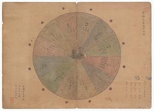
Xingye dingxiang fang yangzhitu
‹ Prev
Next ›
1
2