Toggle navigation
LMEC Home
Exhibitions
Georeferencing
Tools for Teachers
Collections
My Favorites
Sign Up / Log In
Search
Search the map portal
Map Collection
Map Collection
Map Sets
Search
Search
Search for
Search In
All Fields
Creator
Title
Subject
Place
Search All Digital Collections
Advanced Search
13680 Results
My Search
Start Over
Date facet yearly ssim
1550
to
1599
Remove constraint Date facet yearly ssim: <span class='from'>1550</span> to <span class='to'>1599</span>
Filter your Search
Place
North and Central America
10,344
United States
8,475
Massachusetts
2,789
Suffolk (county)
1,677
Boston
1,633
Europe
1,415
Canada
950
New York
649
more
Place
»
Topic
Boston (Mass.)--Maps
747
City planning--Massachusetts--Boston--Maps
418
United States--History--Revolution, 1775-1783--Maps
329
United States--Maps
322
Real property--Massachusetts--Boston--Maps
254
Urban renewal--Massachusetts--Boston--Maps
254
Massachusetts--Maps
231
Insurance surveys
197
more
Topic
»
Date
Date range begin
–
Date range end
Current results range from
1482
to
2023
View distribution
Creator
United States. Hydrographic Office
597
Boston Redevelopment Authority
404
Des Barres, Joseph F. W. (Joseph Frederick Wallet), 1722-1824
247
Royal United Services Institute for Defence and Security Studies
160
Jefferys, Thomas, -1771
154
George, III, King of Great Britain, 1738-1820
152
George, IV, King of Great Britain, 1762-1830
151
O.H. Bailey & Co
148
more
Creator
»
Format
Maps/Atlases
13,499
Manuscripts
985
Prints
102
Books
49
Drawings/Illustrations
44
Photographs
15
Objects/Artifacts
13
Documents
7
more
Format
»
Georeferenced
Yes
979
No
12,701
Collection
Norman B. Leventhal Map & Education Center Collection
9,096
American Revolutionary War-Era Maps
3,305
Boston and New England Maps
2,915
Urban Maps
2,471
Maritime Charts and Atlases
1,169
William L. Clements Library Collection
910
Library of Congress Collection
618
Boston Redevelopment Authority Collection
475
more
Collection
»
Available to use
No known restrictions
10,246
Creative Commons license
1,678
Search Constraints
Sort by relevance
relevance
title
date (asc)
date (desc)
Number of results to display per page
20 per page
10
per page
20
per page
50
per page
100
per page
View results as:
grid view
map view
Search Results
3241.
Eisen-bahn-karte von Deutschland und den angrenzenden ländern : zugleich als übersicht aller wichtigsten land- und...
3242.
Eisenbahnkarte von Österreich-Ungarn
3243.
Eizan chōjō hitome happō chōkanzu
3244.
Eldridge's chart no. 10 : Buzzard's Bay
3245.
Eldridge's chart of Long Island Sound from Newport to New York
3246.
Eldridge's map of Martha's Vineyard
3247.
Eldridge's new chart no. 4 Boston Harbor : compiled from the latest surveys
3248.
Eldridge's new chart of Boston Harbor : compiled from the latest surveys
3249.
Election map of the United States with 49 novel diagrams
3250.
Electoral vote for President, 1789
3251.
Electoral vote for President, 1792
3252.
Electoral vote for President, 1796
3253.
Electoral votes for President in 1916 and for Congress in 1918 : make your guess for 1920
3254.
Electoratus et Palatinatus Rheni Episcopatuum Spirensis et Wormacensis ducatuum Bipontii et Simmerae et Comitatuum...
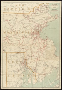
3255.
Electric railway map of eastern New England
3256.
Electric transmission systems of the United States, showing all transmission lines and interconnections above 11,000 volts also...
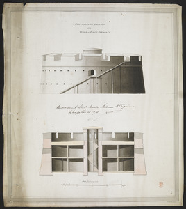
3257.
ELEVATION and SECTION of the TOWER at POINT PLEASANT
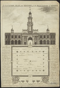
3258.
An elevation, plan, and history, of the Royal Exchange of London
3259.
Elihu Geer Sons new map of East Hartford, Connecticut
3260.
Elihu Geer sons' new map of the city of Hartford, Connecticut
‹ Prev
Next ›
1
2
…
159
160
161
162
163
164
165
166
167
…
683
684