Toggle navigation
LMEC Home
Exhibitions
Georeferencing
Tools for Teachers
Collections
My Favorites
Sign Up / Log In
Search
Search the map portal
Map Collection
Map Collection
Map Sets
Search
Search
Search for
Search In
All Fields
Creator
Title
Subject
Place
Search All Digital Collections
Advanced Search
297 Results
My Search
Start Over
1780
Remove constraint 1780
Filter your Search
Place
North and Central America
259
United States
180
Canada
40
New York
34
Charleston (county)
31
Charleston
27
South Carolina
25
New Jersey
19
more
Place
»
Topic
United States--History--Revolution, 1775-1783--Maps
54
Manuscript maps--Early works to 1800
22
Charleston (S.C.)--Maps
11
Charleston (S.C.)--Siege, 1780--Maps
9
Fortification--Newfoundland and Labrador--St. John's--Maps, Manuscript--Early works to 1800
9
Harbors--Newfoundland and Labrador--St. John's--Maps, Manuscript--Early works to 1800
9
Military art and science--Newfoundland and Labrador--St. John's--Maps, Manuscript--Early works to 1800
9
St. John's (N.L.)--Maps, Manuscript--Early works to 1800
9
more
Topic
»
Date
Date range begin
–
Date range end
Current results range from
1711
to
1909
View distribution
Creator
Skinner, Monier
28
Skinner, William, 1700-1780
28
Des Barres, Joseph F. W. (Joseph Frederick Wallet), 1722-1824
25
Faden, William, 1749-1836
16
André, John, 1751-1780
11
Bonne, Rigobert, 1727-1794
8
Carver, Jonathan, 1710-1780
6
Ferguson, Patrick, 1744-1780
6
more
Creator
»
Format
Maps/Atlases
291
Manuscripts
71
Prints
5
Drawings/Illustrations
1
Georeferenced
Yes
7
No
290
Collection
American Revolutionary War-Era Maps
266
Norman B. Leventhal Map & Education Center Collection
66
William L. Clements Library Collection
65
Library of Congress Collection
63
British Library Collection
33
Maritime Charts and Atlases
27
Richard H. Brown Revolutionary War Map Collection at Mount Vernon
26
Boston and New England Maps
13
more
Collection
»
Available to use
Creative Commons license
142
No known restrictions
66
Search Constraints
Sort by relevance
relevance
title
date (asc)
date (desc)
Number of results to display per page
20 per page
10
per page
20
per page
50
per page
100
per page
View results as:
grid view
map view
Search Results
261.
Confluence of the James River, York River, and Chesapeake Bay
262.
Costa de Cuba desde Cabo de San Antonio a la bahía de Cardenas
263.
Delaware Bay and Chesapeake Bay
264.
Map for the interior travels through America, delineating the march of the army
265.
Map of the coast of Georgia, bordering on Camden and Glynn counties : showing also the course and soundings of the Alatamaha,...
266.
Map showing coast in the regions of Aguadilla, Añasco, and Mayagüez
267.
Map showing coast in the regions of Aguadilla, Añasco, and Mayagüez
268.
Part of modern Brunswick County
269.
Part of modern Brunswick County
270.
Part of modern Charleston County
271.
Part of the modern counties of Currituck, Camden, and Pasquotank, North Carolina
272.
Plan de West-Point du nord, levé a vue
273.
Plan du Môle St. Nicolas
274.
Plan of ground about Wilmington
275.
Plan of New York and Staten Islands with part of Long Island
276.
Plan of the inland navigation between South Edisto and Charlestown
277.
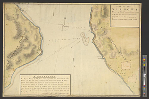
Plan of the narrows : shewing, the channel, shoal, depth of water, and the several battery's proposed on each side to prevent...
278.
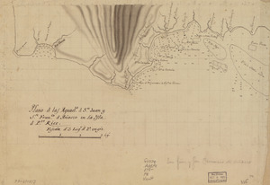
Plano d. las aguads. d. Sn. Juan y Sn. Franco. d. Añasco en la ysla d. Pto. Rico
279.
Plano de la Bahia de la Ware y entrada de Filadelfie
280.
Plano de la Ysla Trinidad de Barlovento situado entre las latitudes septentrionales de 10⁰51ʹ y la de 9⁰44ʹ y entre las...
‹ Prev
Next ›
1
2
…
10
11
12
13
14
15