Toggle navigation
LMEC Home
Exhibitions
Georeferencing
Tools for Teachers
Collections
My Favorites
Sign Up / Log In
Search
Search the map portal
Map Collection
Map Collection
Map Sets
Search
Search
Search for
Search In
All Fields
Creator
Title
Subject
Place
Search All Digital Collections
Advanced Search
202 Results
My Search
Start Over
1877
Remove constraint 1877
Filter your Search
Place
North and Central America
98
United States
74
Oceania
37
Massachusetts
29
Europe
27
South America
23
Asia
16
Chile
14
more
Place
»
Topic
United States Exploring Expedition (1838-1842)
16
Canada--Boundaries--United States--Maps
13
United States--Boundaries--Canada--Maps
13
United States--History--War of 1812--Territorial questions--Maps
13
Balkan Peninsula--Maps
7
Tuamotu Archipelago (French Polynesia)--Maps
7
Turkey--Maps
7
Coasts--Chile--Maps
4
more
Topic
»
Date
Date range begin
–
Date range end
Current results range from
1755
to
1952
View distribution
Creator
United States. Hydrographic Office
42
Wilkes, Charles, 1798-1877
38
United States Exploring Expedition (1838-1842)
35
Sherman & Smith
21
Barclay, Anthony, 1792-1877
13
Porter, Peter B. (Peter Buell), 1773-1844
13
United States. Light-House Board
13
Thompson, David, 1770-1857
11
more
Creator
»
Format
Maps/Atlases
201
Manuscripts
1
Photographs
1
Georeferenced
Yes
10
No
192
Collection
Norman B. Leventhal Map & Education Center Collection
191
Maritime Charts and Atlases
81
Urban Maps
46
Boston and New England Maps
42
American Revolutionary War-Era Maps
4
Maps from AAS
4
Town plans, 1830
4
American Textile History Museum Image Collection
2
more
Collection
»
Available to use
No known restrictions
192
Creative Commons license
2
Search Constraints
Sort by relevance
relevance
title
date (asc)
date (desc)
Number of results to display per page
20 per page
10
per page
20
per page
50
per page
100
per page
View results as:
grid view
map view
Search Results
201.
Gray's new map of Clay Center, Clay County, Kansas
202.
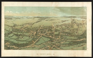
Quincy, Mass
‹ Prev
Next ›
1
2
…
7
8
9
10
11