Toggle navigation
LMEC Home
Exhibitions
Georeferencing
Tools for Teachers
Collections
My Favorites
Sign Up / Log In
Search
Search the map portal
Map Collection
Map Collection
Map Sets
Search
Search
Search for
Search In
All Fields
Creator
Title
Subject
Place
Search All Digital Collections
Advanced Search
104 Results
My Search
Start Over
Date
1919
Remove constraint Date: <span class='single'>1919</span>
Filter your Search
Place
North and Central America
70
United States
65
Europe
25
New England
15
Massachusetts
13
Czechoslovakia
8
New York
7
Austria
6
more
Place
»
Topic
New England--Maps--Early works to 1800--Facsimiles
12
Czechoslovakia--Maps
8
Czechoslovakia--Population--Maps
8
Industries--Czechoslovakia--Maps
8
Austria--Maps
6
Hungary--Maps
4
World maps
4
Ethnology--Europe--Maps
3
more
Topic
»
Date
1919
[remove]
104
Date range begin
–
Date range end
Current results range from
1770
to
1999
1919
to
1919
104
Creator
Smith, John, 1580-1631
9
Czechoslovakia. Service cartographique de l'armée
8
Geological Survey (U.S.)
7
Lesher, C. E. (Carl Eugene), 1885-
7
American Geographical Society of New York
4
Bromley, George Washington
3
Bromley, Walter Scott
3
Illinois State Geological Survey
3
more
Creator
»
Format
Maps/Atlases
103
Books
1
Photographs
1
Georeferenced
Yes
12
No
92
Collection
Norman B. Leventhal Map & Education Center Collection
99
Urban Maps
5
Boston and New England Maps
4
Massachusetts Real Estate Atlases
3
American Revolutionary War-Era Maps
1
Robert E. Diefenbach Map Collection at Phillips Academy
1
Sidney R. Knafel Map Collection at Phillips Academy
1
Available to use
No known restrictions
99
Creative Commons license
1
Search Constraints
Sort by relevance
relevance
title
date (asc)
date (desc)
Number of results to display per page
20 per page
10
per page
20
per page
50
per page
100
per page
View results as:
grid view
map view
Search Results
1.
Airways of the world on Mercator's projection
2.
Atlas of the city of Boston : South Boston : from actual surveys and official plans
3.
Atlas of the North Shore : Beverly to Magnolia, Essex Co. Mass. : from official plans and records and actual surveys
4.
Atlas of the North Shore, Beverly to Magnolia, Essex Co., Massachusetts
5.
Atlas of the town of Brookline, Norfolk County, Massachusetts
6.
Atlas of the town of Brookline, Norfolk County, Massachusetts : from actual surveys and official plans
7.
Austria Hungary
8.
Austria-Hungary
9.
Blue Hills Reservation
10.
Carte ethnographique de l'Epire du Nord en 1913 = Chartis ethnografikos tis Voreiou Ipeirou to 1913
11.
A chart of the gulf stream
12.
The city of Binghamton, Broome Co., N.Y : as extended May 19th, 1908
13.
Daily Mail map of the battlefields of France
14.
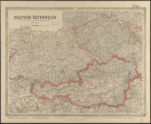
Deutsch Österreich nach den forderungen des friedensentwurfes der entente
15.
A draught of St. John's harbour : with the soundings
16.
Eisenbahnkarte von Österreich-Ungarn
17.
Electoral votes for President in 1916 and for Congress in 1918 : make your guess for 1920
18.
Elihu Geer sons' new map of the city of Hartford, Connecticut
19.
Europe, Africa and the Far East
20.
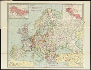
Europe showing the proposed new states
‹ Prev
Next ›
1
2
3
4
5
6