Toggle navigation
LMEC Home
Exhibitions
Georeferencing
Tools for Teachers
Collections
My Favorites
Sign Up / Log In
Search
Search the map portal
Map Collection
Map Collection
Map Sets
Search
Search
Search for
Search In
All Fields
Creator
Title
Subject
Place
Search All Digital Collections
Advanced Search
1014 Results
My Search
Start Over
More Like
commonwealth-oai:gh93mw54n
Remove constraint More Like: commonwealth-oai:gh93mw54n
Filter your Search
Place
North and Central America
986
United States
724
New York
252
Canada
208
Quebec
112
New Jersey
81
Pennsylvania
71
Massachusetts
52
more
Place
»
Topic
United States--History--Revolution, 1775-1783--Maps
330
United States--History--French and Indian War, 1754-1763--Maps
150
New York (State)--Maps
85
Saint Lawrence River--Maps
43
New Jersey--Maps
40
Pennsylvania--Maps
29
Newport (R.I.)--Maps
27
Hudson River (N.Y. and N.J.)--Maps
23
more
Topic
»
Date
Date range begin
–
Date range end
Current results range from
1700
to
1976
View distribution
Creator
Rocque, Mary Ann
29
Holland, Samuel, 1728-1801
26
Bellin, Jacques Nicolas, 1703-1772
25
Jefferys, Thomas, -1771
25
Montrésor, John, 1736-1799
25
Clinton, Henry, Sir, 1738?-1795
19
Robert Sayer and John Bennett (Firm)
16
Hills, John, active 1777-1819
13
more
Creator
»
Format
Maps/Atlases
998
Drawings/Illustrations
11
Manuscripts
6
Documents
5
Prints
1
Georeferenced
Yes
21
No
993
Collection
American Revolutionary War-Era Maps
949
William L. Clements Library Collection
909
Norman B. Leventhal Map & Education Center Collection
69
Boston and New England Maps
18
Maps from AAS
17
MacLean Collection Map Library
7
New-York Historical Society Collection
3
Newberry Library Collection
3
more
Collection
»
Available to use
No known restrictions
72
Creative Commons license
6
Search Constraints
Sort by relevance
relevance
title
date (asc)
date (desc)
Number of results to display per page
20 per page
10
per page
20
per page
50
per page
100
per page
View results as:
grid view
map view
Search Results
481.
Carte geo-hydrographique du Golfe du Mexique et de ces isles : construit d'après les mémoires les plus recens, et assujeties...
482.
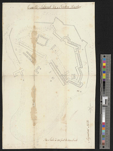
Castle Island in Boston Harbor
483.
The Cedres
484.
Channels around the Island of Orleans
485.
Charlestown, Breed's Hill, and Bunker Hill
486.
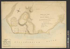
Charlotte Town the capital of the island of St. John
487.
Chart of the coast of Honduras and Nicaragua
488.
Chart of the east coast of the Yucatan
489.
A chart of the harbour of Rhode Island and Narraganset Bay surveyed in pursuance of directions from the Lords of Trade to his...
490.
A chart of the harbour of Rhode Island and Narraganset Bay surveyed in pursuance of directions from the Lords of Trade to his...
491.
A chart of the peninsula of Nova Scotia
492.
A chart of Tibee Inlet in Georgia
493.
A chart shewing the tract of Capt. Cook's last voyage, 1799
494.
City of St. Augustine and environs
495.
The coast from St. Johns, New Brunswick, to Goldsborough Bay, Maine
496.
The coast of Maine from modern Portland to Desert Island
497.
Coast of Senegal
498.
Ye commencement for draft of New York Island
499.
The communication between the Iberville and the river Mississippe
500.
Continuation of the Grande Riviere with the village of Fariole lying near Cape Torment on the north shore
‹ Prev
Next ›
1
2
…
21
22
23
24
25
26
27
28
29
…
50
51