Toggle navigation
LMEC Home
Exhibitions
Georeferencing
Tools for Teachers
Collections
My Favorites
Sign Up / Log In
Search
Search the map portal
Map Collection
Map Collection
Map Sets
Search
Search
Search for
Search In
All Fields
Creator
Title
Subject
Place
Search All Digital Collections
Advanced Search
1022 Results
My Search
Start Over
More Like
commonwealth-oai:3r078t53z
Remove constraint More Like: commonwealth-oai:3r078t53z
Filter your Search
Place
North and Central America
996
United States
732
Canada
205
New York
192
Quebec
111
Pennsylvania
60
New Jersey
54
Louisiana
53
more
Place
»
Topic
United States--History--Revolution, 1775-1783--Maps
305
United States--History--French and Indian War, 1754-1763--Maps
149
Saint Lawrence River--Maps
43
Louisiana--Maps
36
Newport (R.I.)--Maps
27
New York (State)--Maps
24
Kentucky--Maps
23
Hudson River (N.Y. and N.J.)--Maps
21
more
Topic
»
Date
Date range begin
–
Date range end
Current results range from
1700
to
1986
View distribution
Creator
Rocque, Mary Ann
29
Bellin, Jacques Nicolas, 1703-1772
25
Holland, Samuel, 1728-1801
25
Montrésor, John, 1736-1799
25
Jefferys, Thomas, -1771
24
United States. Post Office Dept
22
Clinton, Henry, Sir, 1738?-1795
19
Geological Survey (U.S.)
18
more
Creator
»
Format
Maps/Atlases
1,006
Drawings/Illustrations
11
Documents
5
Prints
1
Georeferenced
Yes
21
No
1,001
Collection
American Revolutionary War-Era Maps
918
William L. Clements Library Collection
909
Norman B. Leventhal Map & Education Center Collection
105
MacLean Collection Map Library
4
American Antiquarian Society Collection
3
Maritime Charts and Atlases
1
Massachusetts Historical Society Map Collection
1
Available to use
No known restrictions
104
Creative Commons license
2
Search Constraints
Sort by relevance
relevance
title
date (asc)
date (desc)
Number of results to display per page
20 per page
10
per page
20
per page
50
per page
100
per page
View results as:
grid view
map view
Search Results
981.
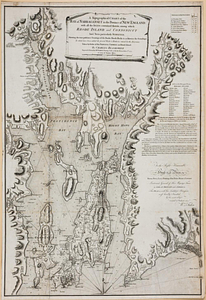
A topographical chart of the bay of Narraganset in the province of New England, with all the isles contained therein, among...
982.
Topographical map of the province of New Hampshire, including Montresor's survey of the St. Lawrence and the Kennebec route to...
983.
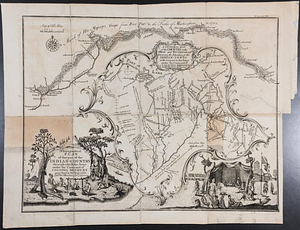
A topographical plan of that part of the Indian-country through which the army under the command of Colonel Bouquet marched in...
984.
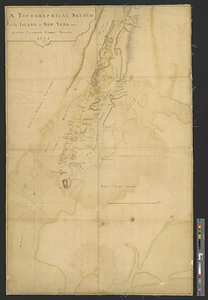
A topographical sketch of the island of New York, with part of the circumjacent country : November 1775
985.
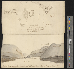
Topographick plan by the eye, 1754 & 6
986.
The town & harbour of Boston &c.
987.
Town of Three Rivers
988.
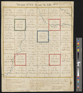
Township no. VII range no. XIV
989.
A tract of land granted to George Murray and Jacobas Bruyn lying & being in the county of Ulster on the west side of the Wall...
990.
Triangles on Mercator projection between St. Augustine and Cape Breton and St. Augustine and Cape Ortegal
991.
The United States according to the definitive treaty of peace signed at Paris, Septr. 3d. 1783 ...
992.
United States of America
993.
The United States of America
994.
The United States of America laid down from the best authorities, agreeable to the peace of 1783
995.
The United States of America with the British possessions of Canada, Nova Scotia, New Brunwsick, and Newfoundland, divided with...
996.
The United States of North America with the British & Spanish territories according to the treaty
997.
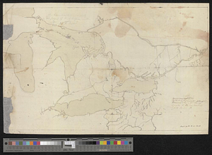
Upper Canada and the Great Lakes region
998.
Upper New York, Vermont, and Massachusetts
999.
Upper Salem and part of the tounds [sic] joining it for two or three miles distance
1000.
Valley of the Hudson River from Fishkill to Teller's Point
‹ Prev
Next ›
1
2
…
46
47
48
49
50
51
52


![Upper Salem and part of the tounds [sic] joining it for two or three miles distance](https://bpldcassets.blob.core.windows.net/derivatives/metadata/commonwealth-oai:8k71sf77k/image_thumbnail_300.jpg)
