Toggle navigation
LMEC Home
Exhibitions
Georeferencing
Tools for Teachers
Collections
My Favorites
Sign Up / Log In
Search
Search the map portal
Map Collection
Map Collection
Map Sets
Search
Search
Search for
Search In
All Fields
Creator
Title
Subject
Place
Search All Digital Collections
Advanced Search
141 Results
My Search
Start Over
More Like
commonwealth:z603vr08v
Remove constraint More Like: commonwealth:z603vr08v
Filter your Search
Place
North and Central America
97
United States
81
North America
36
Virginia
36
South Carolina
29
North Carolina
27
Maryland
15
Georgia
13
more
Place
»
Topic
Virginia--Maps--Early works to 1800
38
North America--Maps--Early works to 1800
29
South Carolina--Maps--Early works to 1800
28
North Carolina--Maps--Early works to 1800
25
Maryland--Maps--Early works to 1800
17
United States--Maps--Early works to 1800
14
Georgia--Maps--Early works to 1800
12
Pennsylvania--Maps--Early works to 1800
10
more
Topic
»
Date
Date range begin
–
Date range end
Current results range from
1590
to
1899
View distribution
Creator
Jefferys, Thomas, -1771
10
Sayer, Robert, 1725-1794
8
Lodge, John, -1796
6
Gibson, J. (John), active 1750-1792
5
Hinton, John, -1781
5
Kitchin, Thomas, 1719-1784
5
Russell, John, active 1733-1795
5
Anville, Jean Baptiste Bourguignon d', 1697-1782
4
more
Creator
»
Format
Maps/Atlases
141
Georeferenced
Yes
9
No
132
Collection
American Revolutionary War-Era Maps
113
New York Public Library Collection
77
Norman B. Leventhal Map & Education Center Collection
38
MacLean Collection Map Library
14
Maritime Charts and Atlases
11
Richard H. Brown Revolutionary War Map Collection at Mount Vernon
5
Harvard Map Collection
2
New-York Historical Society Collection
2
more
Collection
»
Available to use
Creative Commons license
87
No known restrictions
39
Search Constraints
Sort by relevance
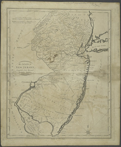
relevance
title
date (asc)
date (desc)
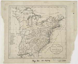
Number of results to display per page
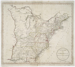
20 per page
10
per page
20
per page
50
per page
100
per page
View results as:
grid view
map view
Search Results
121.
North America
122.
North America
123.
North America
124.
North America, agreeable to the most approved maps and charts
125.
North America, as divided amongst the European powers
126.
North America drawn from the latest and best authorities
127.
Nova tabula geographica complectens borealiorem Americae partem : in qua exacte delineatae sunt Canada sive Nova Francia, Nova...
128.
Part of North America : comprehending the course of Ohio, New England, New York, New Jersey, Pennsylvania, Maryland, Virginia,...
129.
La Pensilvania, la Nuova York, il Jersey Settentrio[na]le : con la parte occidentale del Connecticut, Massachusset-s-bay e...
130.
Plan der stad Washington : bestemd tot de hoofdstad van America, en ter bestendige verblijfplaats van het Congres, naa het jaar...
131.
Plan of the city of Philadelphia
132.
Plan of the city of Washington in the territory of Columbia : ceded by the states of Virginia and Maryland to the United States...
133.
A plan of the northern part of New Jersey : shewing the positions of the American and British armies after crossing the North...
134.
A plan of the operations of the British & Rebel army in the Campaign, 1777
135.
The Province of New Jersey : divided into East and West, commonly called the Jerseys
136.
Seat of war in the environs of Philadeliphia
137.
Seat of war in the environs of Philadeliphia
138.
The State of New Jersey : compiled from the most accurate surveys
139.
States of America, drawn from the best authorities
140.
The United States of America, according to the Treaty of Peace of 1784
‹ Prev
Next ›
1
2
3
4
5
6
7
8


![La Pensilvania, la Nuova York, il Jersey Settentrio[na]le](https://bpldcassets.blob.core.windows.net/derivatives/images/commonwealth:z603vq53g/image_thumbnail_300.jpg)