Toggle navigation
LMEC Home
Exhibitions
Georeferencing
Tools for Teachers
Collections
My Favorites
Sign Up / Log In
Search
Search the map portal
Map Collection
Map Collection
Map Sets
Search
Search
Search for
Search In
All Fields
Creator
Title
Subject
Place
Search All Digital Collections
Advanced Search
464 Results
My Search
Start Over
More Like
commonwealth:z603vh049
Remove constraint More Like: commonwealth:z603vh049
Filter your Search
Place
North and Central America
423
United States
343
Canada
63
North America
31
West Indies
23
New York
16
New England
15
Boston
11
more
Place
»
Topic
United States--Maps
314
Canada--Maps
54
Elections--United States--Maps
36
Railroads--United States--Maps
34
North America--Maps
30
West Indies--Maps
24
New England--Maps
15
Population density--United States--Maps
14
more
Topic
»
Date
Date range begin
–
Date range end
Current results range from
1750
to
2020
View distribution
Creator
Paullin, Charles Oscar, 1868 or 1869-1944
70
Wright, John Kirtland, 1891-1969
70
Geological Survey (U.S.)
15
Reid, John, 1764?-1828
11
Bellin, Jacques Nicolas, 1703-1772
10
Carleton, Osgood, 1742-1816
9
Farwell, John Whittemore, 1843-1929
9
Kitchin, Thomas, 1718-1784
8
more
Creator
»
Format
Maps/Atlases
462
Manuscripts
13
Prints
2
Books
1
Objects/Artifacts
1
Posters
1
Georeferenced
Yes
77
No
387
Collection
Norman B. Leventhal Map & Education Center Collection
301
American Revolutionary War-Era Maps
162
American Antiquarian Society Collection
138
William L. Clements Library Collection
21
Boston and New England Maps
3
MacLean Collection Map Library
3
David Judkins Weaver Papers
2
Mapping Boston Collection
2
more
Collection
»
Available to use
No known restrictions
227
Creative Commons license
5
Search Constraints
Sort by relevance
relevance
title
date (asc)
date (desc)
Number of results to display per page
20 per page
10
per page
20
per page
50
per page
100
per page
View results as:
grid view
map view
Search Results
261.
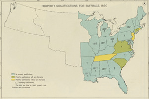
Property qualifications for suffrage, 1830
262.
Property qualifications for suffrage, 1860
263.
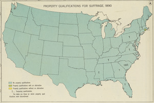
Property qualifications for suffrage, 1890
264.
Property qualifications for suffrage, 1920
265.
Public lands of the United States, 1850
266.
Public lands of the United States, 1870
267.
Public lands of the United States, 1890
268.
Public lands of the United States, 1910
269.
P.W.A. and industry : how benefits are spread
270.
P.W.A. in action
271.
PWA rebuilds the nation
272.
Radio map of the United States
273.
Rail road map of the southern states shewing the southern & southwestern railway connections with Philadelphia
274.
Railroad distance map of the United States, Mexico & Canada
275.
Rainfall-chart of the United States : showing the distribution by isohyetal curves of the mean precipitation in rain ...
276.
Rambles through our country : an instructive geographical game for the young
277.
Rand McNally & Co's new commercial map of Europe
278.
Rand McNally & Co's new railroad and county map of the United States and Dominion of Canada
279.
Reconstruction Act, March 2, 1867, Vote on passage over President's veto
280.
Los recursos de los Estados Unidos
‹ Prev
Next ›
1
2
…
10
11
12
13
14
15
16
17
18
…
23
24