Toggle navigation
LMEC Home
Exhibitions
Georeferencing
Tools for Teachers
Collections
My Favorites
Sign Up / Log In
Search
Search the map portal
Map Collection
Map Collection
Map Sets
Search
Search
Search for
Search In
All Fields
Creator
Title
Subject
Place
Search All Digital Collections
Advanced Search
313 Results
My Search
Start Over
More Like
commonwealth:z603vg69x
Remove constraint More Like: commonwealth:z603vg69x
Filter your Search
Place
North and Central America
277
United States
216
New York
145
New Jersey
40
Canada
30
Hudson River
29
New England
23
Manhattan
18
more
Place
»
Topic
New York (State)--Maps
81
New York (N.Y.)--Maps
47
United States--History--Revolution, 1775-1783--Maps
46
New Jersey--Maps
37
Hudson River (N.Y. and N.J.)--Maps
29
New England--Maps
25
United States--Maps
21
Railroads--New York (State)--Maps
20
more
Topic
»
Date
Date range begin
–
Date range end
Current results range from
1700
to
1976
View distribution
Creator
Kitchin, Thomas, 1718-1784
11
Reid, John, 1764?-1828
11
Bellin, Jacques Nicolas, 1703-1772
9
Farwell, John Whittemore, 1843-1929
9
Carleton, Osgood, 1742-1816
6
Tanner, Benjamin, 1775-1848
6
United States. Post Office Dept
6
Anderson, Alexander, 1775-1870
5
more
Creator
»
Format
Maps/Atlases
313
Manuscripts
14
Drawings/Illustrations
1
Georeferenced
Yes
36
No
277
Collection
American Revolutionary War-Era Maps
214
American Antiquarian Society Collection
138
Norman B. Leventhal Map & Education Center Collection
100
William L. Clements Library Collection
68
Urban Maps
20
Boston and New England Maps
15
New-York Historical Society Collection
3
New York Public Library Collection
2
more
Collection
»
Available to use
No known restrictions
103
Creative Commons license
4
Search Constraints
Sort by date (desc)
relevance
title
date (asc)
date (desc)
Number of results to display per page
20 per page
10
per page
20
per page
50
per page
100
per page
View results as:
grid view
map view
Search Results
21.
Relief map of New Jersey
22.
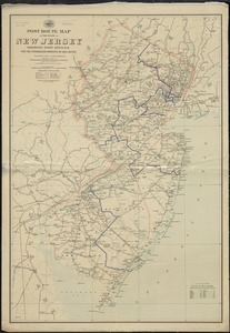
Post route map of the State of New Jersey showing post offices with the intermediate distances on mail routes in operation on...
23.
Rand, McNally & Co.'s indexed atlas of the world map of Quebec
24.
New map of New York City : from the latest authentic surveys, showing all ferries, and all steamship docks both foreign and...
25.
Post route map of the State of New York and parts of Vermont, Massachusetts, Connecticut, New Jersey, and Pennsylvania also the...
26.
Post route map of the states of Pennsylvania, New Jersey, Delaware, and Maryland and of the District of Columbia with adjacent...
27.
The strangers mercantile guide map of the cities of New York, Brooklyn, Jersey City, Hoboken, etc
28.
Post route map of the State of New York and parts of Vermont, Massachusetts, Connecticut, New Jersey, and Pennsylvania also the...
29.
Rand, McNally & Co.'s New Jersey
30.
Map showing the comparative merits, and benefits to Massachusetts, of the proposed extension of the New York and Massachusetts...
31.
Rand McNally & Co.'s map of New York City, Brooklyn, Jersey City and vicinity
32.
The State of New Jersey : from original surveys based on the triangulation of the U.S. Coast and Geodetic Survey
33.
Map of the rail roads of New Jersey 1887
34.
Map of the city & county of New York
35.
Map of the New York Central & Hudson River and Boston & Albany Railroads : sea shore and summer resorts of New York and New...
36.
Map of the eastern division and branches, Erie Railway
37.
Map of the Eastern Railroad and principal connections
38.
The state of New Jersey : economic geology
39.
Citizens & travelers guide map in, to and from the city of New York and adjacent places
40.
Hale's map of the central & western parts of Massachusetts, with a part of New-York
‹ Prev
Next ›
1
2
3
4
5
6
…
15
16